Download
1 / 22
220 likes | 287 Views
WP 8: Impact on Satellite Retrievals. Partners (according to Contract):. University of l’Aquila (DFUA [12]): Vincenzo Rizi. Ecole Polytechnique (EPFL [13]): Bertrand Calpini. Observatory of Neuchatel (ON [14]): Valentin Mitev. Met. Institute Munich (MIM [17]): Matthias Wiegner.

E N D
WP 8: Impact on Satellite Retrievals Partners (according to Contract): University of l’Aquila (DFUA [12]): Vincenzo Rizi Ecole Polytechnique (EPFL [13]): Bertrand Calpini Observatory of Neuchatel (ON [14]): Valentin Mitev Met. Institute Munich (MIM [17]): Matthias Wiegner
Contract: Objectives and input to workpackage 1. Quantify the sensitivity of radiances at the top of the atmosphere (toa) to variations of the aerosol distribution as typically observed at lidar sites. This will be used to provide an estimate of the impact of aerosols on retrievals of a variety of quantities using optical methods from spaceborne platforms. 2. Provide aerosol distributions for calibration purposes upon request from relevant groups operating satellite sensors.
Contract: Description of work • This is done by running adequate radiative transfer models • using the aerosol data from the lidar measurements as input. • As a result, inversion algorithms for surface properties can be • critically reviewed and improved. • 2. Additional lidar measurements of aerosol vertical distribution • will be performed at special occasions when satellite overpasses • close to an EARLINET station occurs and the sky is not overcast. • For this part to stay within the limits of the available resources • it will be done only on request and in close co-operation with • the satellite community.
Why is this WP relevant (1. reason)? multispectral and multiangular radiances from satellites used to retrieve aerosol optical depth critical over land surfaces (unknown ground albedo, orography) complex retrieval algorithms require validation „Validation of atmospheric parameters“
Why is this WP relevant (2. reason)? multispectral and multiangular radiances from satellites used to retrieve surface properties (e.g. precision farming) determine atmospheric influence (unknown aerosol effect) corrections of atmospheric masking require input and validation „Validation of surface parameters“
Why is this WP relevant (3. reason)? Radiative transfer calculations required to understand satellite data and to develop parameterizations aerosol distribution is one controlling parameter realistic modelling requires typical input datasets „Improvment of aerosol understanding“
Strategy of WP 8 Demonstrate the benefit of lidar data on the basis of examples (i.e. motivate users) Offer our datasets to the satellite community (i.e. activate users) Identify cases where lidar data are useful (i.e. attract users) Note: WP‘s ordered by „time allocated“: WP8 is 15. out of 20.
First contribution Goal: Support satellite retrieval validation by supplying lidar data (possible candidates: Envisat community) Actions proposed: Supply survey of available aerosol extinction profiles (site, time, wavelength) Data dissemination: On request (Webpage)
Second contribution Goal: Full characterization of surface and atmosphere of exactly the same scene (for calibration of satellite sensor and algorithms) Requirements: co-incidence and co-location and very small satellite pixelrequired. Time and Place: May, June, July and August 2002 in Gilching Acquisition mode: CHRIS: 18 km swath, 25 m resolution, 19 spectral bands, along track (5 angles) In co-operation with:
Third contribution Goal: Support model development by supplying lidar data Actions: Performing model calculations with realistic aerosol extinction profiles to investigate the influence of aerosols on toa-radiances
Next steps of WP 8 Start: May 2000 End: December 2002 Deliverables April 2002: Report on aerosol impact on satellite retrievals Other Deadlines May 2002: Contribution to Annual Report
Goals of the Work-Package The goal of Workpackage No. 8 includes the modeling of the aerosol influence on radiances measured by satellites and the provision of additional lidar measurements on request. What does this mean? Measurements: Lidar data are available since May 2000. Dedicated measurements simultaneous to satellite overpasses make sense if pixel are small and cloud free conditions can be guaranteed. On the other hand, the existing data base can be used for validation of satellite measurements and their products. Model calculation: Models for atmospheric corrections (e.g., to retrieve surface properties) and models to derive aerosol properties can be supported by supplying lidar data. Remark: The development of such models itself is beyond the scope of EARLINET. Both “classes” are linked and cannot be considered separately.
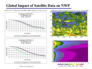
Small but relevant Workpackage Satellite provide global coverage but vertical resolution is poor. Aerosols are hard to be detected by passive radiometers, thus Validation and additional data are useful. Aerosols influence retrievals of geophysical and atmospheric parameters Global climate models will benefit of high resolved aerosol data as Well as (conventional) dedicated aerosol missions
EARLINET and Satellites General remarks: Meteorological satellites suitable for aerosol remote sensing require “good” spatial and spectral resolution. For that reason, SeaWIFs is presently the most promising candidate. Geostationary satellites have poor radiometric accuracy and spectral resolution, GOME et al. have very poor spatial resolution, Landsat et al. have very poor temporal sampling, and sensors with very high spatial resolution are not yet in orbit (MERIS [250 m], Chris et al. [25 m]). Thus, we follow two options: Option 1: plan dedicated experiments on the “compare same atmospheric volume”-concept [risk: overcast conditions] and Option 2: select data sets already available on the “validate aerosol parameters”-concept
Option 2: Aerosol Validation Output: Several calibration points for the map of aerosol optical depth derived from (e.g.) v. Hoyningen-Huene’s SeaWIFs retrieval. Information of special aerosol stratifications that might help to explain possible deviations. E.g., check, whether algorithm works in the presence of Saharan dust layers. Provision of information of the aerosol type (if possible, e.g., from trajectories, lidar data themselves, auxiliary data) to support satellite retrieval algorithm (input for them). Possible co-operation with University of Bremen (v. Hoyningen-Huene)
Option 2: Aerosol Validation (contd.) Background Information: A SeaWIFs algorithm to derive aerosol optical depth exists and has been (successfully) applied. SeaWIFS has a spatial resolution of about 1 km and a coverage of 1800 km (swath width); similar to AVHRR Algorithm works best in the spectral range between 412 - 510 nm (surface is dark); lidar data of 532 nm can be extrapolated. Times to be compared should be in spring and early summer (green vegetation; no problems with water stress) MERIS will have a better resolution but will be available not before spring 2002. Sciamachy has a very poor spatial resolution.
Option 2: Aerosol Validation (contd.) To be Discussed: Data from stations not directly involved in this work package would be required. Is that possible? Who will calculate the optical depth from the extinction profiles (owner or M.W.)? Is an extra qualitity check required/desired by the owner of the data? Selection of episodes from the diurnal cycle subset (best time of the day is 11-13 hours)? How many episodes should be selected (one, two, more?) Should we include algorithms to derive aerosol optical depth over land from other institutes (answer from Berlin is pending)?
Goals of the Work-Package The goal of Workpackage No. 8 includes the modeling of the aerosol influence on radiances measured by satellites and the provision of additional lidar measurements on request. What does this mean? Measurements: Lidar data are available since May 2000. Dedicated measurements simultaneous to satellite overpasses make sense if pixel are small and cloud free conditions can be guaranteed. On the other hand, the existing data base can be used for validation of satellite measurements and their products. Model calculation: Models for atmospheric corrections (e.g., to retrieve surface properties) and models to derive aerosol properties can be supported by supplying lidar data. Remark: The development of such models itself is beyond the scope of EARLINET. Both “classes” are linked and cannot be considered separately.