Download
1 / 22
220 likes | 231 Views
MODIS BRDF/Albedo Products from Terra and Aqua. Crystal Schaaf Alan Strahler, Xiaowen Li, Jonathan Salomon, Jicheng Liu, Feng Gao et al. Department of Geography Boston University (schaaf@bu.edu). MODIS BRDF/Albedo Algorithm.

E N D
MODIS BRDF/Albedo Products from Terra and Aqua Crystal Schaaf Alan Strahler, Xiaowen Li, Jonathan Salomon, Jicheng Liu, Feng Gao et al. Department of Geography Boston University (schaaf@bu.edu)
MODIS BRDF/Albedo Algorithm • BRDF model—linear combination of a constant (fiso)and two weighted (fvol, fgeo) trigonometric functions (kvol, kgeo) derived from physical models of volumetric and geometric-optical surface scattering. • Full model inversions are used when sufficient high quality atmospherically-corrected cloud-free observations are available over a 16-day period to adequately sample the BRDF. • Otherwise, lower quality magnitude inversions are performed which couple a priori knowledge of the surface anisotropy with any high quality MODIS observations that are available for a location.
MODIS BRDF/Albedo Standard Products • Collection 4 (V004) reprocessed MODIS Land Products (March 2000 to present). • BRDF Model Parameters • MODIS bands 1-7 plus three broadbands • Albedos • white-sky and black-sky (at local solar noon) • Nadir BRDF-Adjusted Reflectances (NBAR) • MODIS bands 1-7 • Extensive Quality Assurance Flags • Quality of the product, processing method used, and whether a snow or snow-free albedo was retrieved. • Blue-sky albedos • Can be computed as an interpolation between black-sky and white-sky albedos as a function of diffuse skylight. • Validated Stage-1 • Product accuracy has been estimated using a small number of independent measurements obtained from selected locations and time periods and ground-truth/field program effort.
MODIS BRDF/Albedo Standard Products • V005 Level2G/Level3 Standard Land Products (MCD43B) • HDF-EOS • Sinusoidal equal-area projection • Tiles - 1200x1200 pixels for the 1-km products • Tiles – 2400x2400 pixels for the 500-m products • Revised format and QA (snow and mandatory separate bytes) • V005 Climate Modeling Grid Products (CMG) (MCD43C) • HDF-EOS • Geographic (lat/lon) projection • Coarse resolution - 0.05degree (3 arc min or ~5km) • Include snow free version • Revised format and QA
NBAR January 1-16, 2001 (2001001) April 7-22, 2001 (2001097) July 12-27, 2001 (2001193) October 16-31, 2001 (2001289)
Albedo of Sahara 1 km albedo – RGB composite
CMG Broadband White-Sky Albedo (0.3-5.0mm)January 2001 No Data
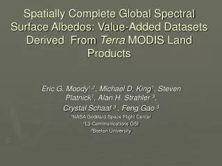
Spatially Complete Snow-Free MODIS Albedo Product • MODIS Atmosphere Group- Eric Moody • Fill values, poorest quality results, and seasonally snow covered results are replaced with temporal estimations and spatial interpolation. • 1 arc minute geographic lat/lon • http://modis-atmos.gsfc.nasa.gov/ALBEDO/index.html 0.0 0.8 Moody, E. G., M. D. King, S. Platnik, C. B. Schaaf, F. Gao, Spatially Complete Surface Albedo Datasets: Value-Added Products Derived from Terra MODIS Land Products, IEEE, Trans Geosci. Remote Sens., 2005.
Spatially Complete White-Sky AlbedoJanuary 1-16, 2002 Snow-free 0.8 0.6 Surface Albedo (0.86 µm) Snow-covered 0.4 0.2 0.0
Combined Aqua + Terra Processing • BRDF specification requires multiple observations to capture anisotropy across viewing/illumination geometry • Combining observations from Aqua and Terra • Increase high-quality inversions • Best fit BRDF model retrieved directly from observations • Fewer lower-quality retrievals using the back-up algorithm • Back-up method relies on a priori designation of BRDF • Combined Aqua+Terra V004 reprocessing completed Jan 05 • V005 – MCD43 product only (Terra alone prior to May 2002)
CMG Broadband Black-sky Albedo (0.3-5.0mm) Terra (April 2004) Terra + Aqua
CMG Broadband Black-sky Albedo (0.3-5.0mm) Terra (April 2004) Terra + Aqua Green: high quality Red: poorer quality
2001193 V005 500m White-Sky Albedo 500m 1km
ValidationSites • Baseline Surface Radiation Network (BSRN) • http://bsrn.ethz.ch/ • SURFRAD Network (US BSRN sites) • http://www.srrb.noaa.gov/surfrad/index.html • EOS core validation sites (200x200 pixels subsets) • http://modis-land.gsfc.nasa.gov/val/coresite_gen.asp • MODIS 7x7 pixel subsets in ascii at ORNL • 276 sites (BSRN stations archiving albedo, EOS core sites, and Flux network sites • http://www.modis.ornl.gov/modis/index.cfm • Greenland Climate Network (GC-Net) Automatic Weather Stations (AWS) - • Stroeve, J., J. E. Box, F. Gao, S. Liang, A. Nolin, C. Schaaf, Accuracy Assessment of the MODIS 16-day Albedo Product for Snow: Comparisons with Greenland in situ Measurements , doi:10.1016/j.rse.2004.09.001, Remote Sens. Environ., 2004. • Validated Stage-1 • Product accuracy has been estimated using a small number of independent measurements obtained from selected locations and time periods and ground-truth/field program effort.
Fort Peck, Montana V004, 2003
ARM SGP Central Site V004, 2003
Boulder, CO V004, 2003
Desert Rock, NV V004, 2003
Validation with Greenland insitu Measurements • Description of the Greenland GC-Net AWS Albedo Measurements • Upward and downward shortwave radiation fluxes are measured at several AWS distributed widely in latitude and elevation using pairs LI-COR 200SZ photoelectric diode pyranometers (0.4 m – 1.1 m). • A correction to the LI-COR albedo are made to convert them from a narrowband albedo (e.g. 0.4 m – 1.1 m) to a broadband (0.285 m – 2.8 m) albedo. • Comparisons with precision pyranometers suggest a residual uncertainty with an RMSE of 0.035 (absolute albedo).
MODIS Albedo Vs Greenland In Situ Albedo Comparison between MOD43 16-day albedo and 16-day in situ albedo for both black sky (triangles) and white sky (squares) albedo for 15 Greenland AWS stations. MODIS albedo from both the “main” (closed symbols) and “backup” (open symbols) algorithm results are shown. Stroeve, J., J. Box, F. Gao, S. Liang, A. Nolin, C. Schaaf, Accuracy Assessment of the MODIS 16-day Albedo Product for Snow: Comparisons with Greenland in situ Measurements., Remote Sens. Environ., 94, 46-60, 2005.
Albedo/BRDF References Gao, F., C. Schaaf, A. Strahler, A. Roesch, W. Lucht, and R. Dickinson, The MODIS BRDF/Albedo Climate Modeling Grid Products and the Variability of Albedo for Major Global Vegetation Types, J. Geophys. Res., 110, D01104, doi:10.1029/2004JD005190. 2005. Moody, E. G., M. D. King, S., Platnick, C. B. Schaaf, and F. Gao, Spatially complete global spectral surface albedos: Value-added datasets derived from Terra MODIS land products. IEEE Trans. Geosci. Remote Sens., 43, 144-158, 2005. Stroeve, J., J. Box, F. Gao, S. Liang, A. Nolin, C. Schaaf, Accuracy Assessment of the MODIS 16-day Albedo Product for Snow: Comparisons with Greenland in situ Measurements., Remote Sens. Environ., 94, 46-60, doi:10.1016/j.rse.2004.09.001, 2005. Roesch, A., C. Schaaf and F. Gao, Use of Moderate-Resolution Imaging Spectroradiometer bidirectional reflectance distribution function products to enhance simulated surface albedos, J. Geophys. Res., 109, D12, doi: 10.1029/2004JD004552, 2004. Tian, Y., R. E. Dickinson, L. Zhou, R. B. Myneni, M. Friedl, C. B. Schaaf, M. Carroll, and F. Gao, Land boundary conditions from MODIS data and consequences for the albedo of a climate model, Geophys. Res. Let., 31, doi:10.1029/2003GL019104, 2004. Wang, Z., X. Zeng, M. Barlage, R. E. Dickinson, F. Gao, and C. Schaaf, Using MODIS BRDF and Albedo Data to Evaluate Global Model Land Surface Albedo, J. Hydrometeor., 5, 3-14, 2004. Zhou, L.et al., Comparison of seasonal and spatial variations of albedos from Moderate-Resolution Imaging Spectroradiometer (MODIS) and Common Land Model. J. Geophys. Res., 108, D15, 4488, doi:10.1029/2002JD003326, 2003. Gao et al., Detecting vegetation structure using a kernel-based BRDF model. Remote Sens. Environ., 86(2), 198-205, 2003. Oleson et al., Assessment of global climate model land surface albedo using MODIS data, Geophys. Res. Letters, 30(8), 1443, doi:10.1029/2002GL016749, 2003. Jin et al., Consistency of MODIS surface BRDF/Albedo retrievals: 1. Algorithm performance, J. Geophys. Res., 108(D5), 4158, doi:10.1029/2002JD002803, 2003. Jin et al., Consistency of MODIS surface BRDF/Albedo retrievals: 2.Validation, J.Geophys. Res., 108, 4159, doi:10.1029/2002JD002804, 2003. Schaaf et al., First Operational BRDF, Albedo and Nadir Reflectance Products from MODIS, Remote Sens. Environ., 83, 135-148, 2002. Liang et al., Validating MODIS Land Surface Reflectance and Albedo Products: Methods and Preliminary Results, Remote Sens. Environ., 83, 149-162, 2002. Jin et al., Improving MODIS Surface BRDF/Albedo Retrieval with MISR Multi-angle Observations, IEEE Trans. Geosci. Remote Sens., 40, 1593-1604, 2002. Jin et al., How does snow impact the albedo of vegetated land surfaces as analyzed with MODIS data?, Geophys. Res. Let., 29, 10.1029/2001GL014132, 2002. Tsvetsinskaya et al., Relating MODIS derived surface albedo to soils andlandforms over Northern Africa and the Arabian Peninsula, Geophys. Res. Let., 29, 10.1029/2001GL014096, 2002. Gao et al., Bidirectional NDVI and Atmospherically Resistant BRDF Inversion for Vegetation Canopy, IEEE Trans. Geosci. Remote Sens., 40, 1269-1278, 2002. MODIS BRDF/Albedo User Guide (http://geography.bu.edu/brdf/userguide/index.html)