Download
1 / 18
190 likes | 305 Views
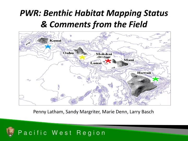
PWR: Benthic Habitat Mapping Status & Comments from the Field. Penny Latham, Sandy Margriter , Marie Denn , Larry Basch. Acknowledgements.

E N D
PWR: Benthic Habitat Mapping Status & Comments from the Field Penny Latham, Sandy Margriter, Marie Denn, Larry Basch
Acknowledgements Thanks to Sandy Margriter (PWR GIS), Marie Denn (Aquatic Ecologist), and Larry Basch (Pacific Island Network Marine Ecologist) for research and summary of the information presented here.
Discussion • Marine benthic habitat maps • Pacific West island parks (PACN) • Pacific West coastal parks (NCCN, KLMN, SFAN, MEDN) • Freshwater benthic habitat maps • Selected comments from parks
Marine: Pacific West Island Parks • Pacific Islands: NOAA’s National Ocean Service initiated coral reef mapping in 1999 in response to requirements outlined in the Mapping Implementation Plan developed by the Mapping and Information Synthesis Working Group of the Coral Reef Task Force (CRTF). Focused on <30m coral reef ecosystems. • Information for PW is available on the web at PI Benthic Habitat Mapping Center (http://www.soest.hawaii.edu/pibhmc/index.htm)
Example: 2005 Publication Shallow-Water Benthic Habitats of American Samoa, Guam, and the CNMI 32 distinct benthic habitat types within 11 zones were mapped for American Samoa, Guam, and the CNMI. Available on CD.
Marine: Pacific West Island Parks • All 11 parks have digital benthic habitat maps completed by NOAA. • Other GIS layers available for PI parks: • Bathymetry (7 of 11) • Wetlands • Tsunami Inundation • Flood Hazard • Watershed • Ahupua’a, park boundaries, and shoreline • Surficial geology (7 of 11) • Nautical Charts (raster or vector for all parks except WAPA and AMME)
Benthic MappingKaloko-Honoköhau NHP • NOAA, 2007 • IKONOS • Biological Cover Classes (7) • Coral • CorallineAlgae • Emergent Vegetation • Macroalgae • Turf • Uncolonized • Unclassified
Benthic MappingKaloko-Honoköhau NHP • USGS, 2007 • IKONOS • More detail on substrate
USGS NOAA
Marine: Pacific West Coastal Parks • No similar effort conducted by NOAA for coastal parks. • California Geological Society is producing new geological maps for California (include offshore geology but not the shore line) • Cooperative project led by USGS (Cochrane et al., open file report 03-05) initiated for the Channel Islands National Marine Sanctuary and Southern California State Fisheries Reserves • Mapping initiated as part of study to examine degree to which composition and abundance of eggs and larvae in water column reflect benthic habitats and fish communities • Includes divers surveys, ROV and submersible video transects, bathymetry data, sedimentary samples, and side scanning sonar: (http://geopubs.wr.usgs.gov/open-file/of03-85/) • Other GIS layers available for coastal parks: • Wetlands • Tsunami Inundation • Flood Hazard • Watershed • Ahupua’a, park boundaries, and shoreline • Surficial geology (7 of 11) • Nautical Charts (raster or vector for all parks except WAPA and AMME)
Park Comments and Summary • The work currently underway will likely meet all California coastal park needs – good model for other west coast and Alaskan parks • Our needs are general in nature: location and amount of rocky intertidal, sandy bottom, location of species of concern • Nearshore <20m habitat mapping for sensitive resources (eelgrass); CABR indicated high need for intertidal and subtidal mapping. • Not sure why we have multiple maps of the same area by different agencies
Freshwater Benthic Habitat Maps Point Reyes National Seashore
Coastal Parks South of Redwood N&SP • Predominantly intermittent coastal streams, few or no coastal lakes • Most useful maps: wetland inventory maps or species-specific habitat maps based on field surveys
Redwood National and State Park • Need for coastal intertidal habitat mapping to extend seamlessly into the estuarine transition zones at mouths of Klamath River and Redwood Creek • Very interested in intertidal and sub-tidal habitat mapping • Freshwater mapping less relevant to management concerns
Olympic National Park • Interested in benthic habitat type information at: Lake Crescent, Ozette Lake, the Hoh River and the Elwa River • High priority: habitat mapping to support rare fish management at Lake Crescent • Need bathymetric, benthic substrate, shoreline vegetation communities