Download
1 / 62
650 likes | 858 Views
Oceanic Wind & Water Circulation. Winds A. Have a major effect on direction of surface water currents B. Energy transferred from atmosphere to water by friction at interface between the 2 C. Named for directions from where they come (A “westerly wind” comes out of the west).

E N D
Winds • A. Have a major effect on direction of surface water currents • B. Energy transferred from atmosphere to water by friction at interface between the 2 • C. Named for directions from where they come (A “westerly wind” comes out of the west)
Wind (continued) • D. Directions are also affected by earth’s rotation • 1. The so-called “rising” & “setting” of the sun are illusions resulting from the spinning earth either entering or leaving the illuminated hemisphere
D. Wind directions affected by earth’s rotation (continued) 2. The speed of rotation is 100 million times faster at the equator than at the poles a. If you stand at the pole with your feet 3 feet apart, the rotational (= spinning) speed of your body/feet would be about 2.4 x 10⁻⁵ miles per hr. b. Meanwhile at the equator, the spinning speed of the Earth’s surface is 40,003 kms or 24,857 miles/day (= 1,667 kms or 1,036 miles per hr).
D. Wind directions affected by earth’s rotation (continued) 3. Winds are deflected as they move either toward or away from equator a. NORTHEAST TRADE WINDS i. Winds that blow toward equator in Northern Hemisphere ii. Veer toward west b. WESTERLIES i. Winds that blow toward North Pole in Northern Hemisphere ii. Veer toward east
II. Ocean Surface Circulation A. Direction 1. Currents named for the direction to which they are going (e.g. a westerly current flows west) 2. Surface oceanic currents (upper 200m) are driven by wind (= generally move in same direction as)
II. Ocean Surface Circulation (continued) B. Ocean gyres 1. GYRE: Overall circulation pattern of a large body of water 2. Equatorial currents move westward until they encounter a continent 3. In northern hemisphere a. Currents flow away from (= north) equator on eastern side of continents b. Currents flow toward (= south) equator on western side of continents 4. Opposite pattern occurs in southern hemisphere
North Pacific Gyre North Atlantic Gyre
II. Ocean Surface Circulation (continued) C. CONVERGENCE ZONES 1. Natural gathering points where rotating currents and winds cause man-made debris, as well as plankton, seaweed, and other sea life to accumulate
"So on the way back to our home port in Long Beach, California, we decided to take a shortcut through the [North Pacific] gyre, which few seafarers ever cross. Fishermen shun it because its waters lack the nutrients to support an abundant catch. Sailors dodge it because it lacks the wind to propel their sailboats. "Yet as I gazed from the deck at the surface of what ought to have been a pristine ocean, I was confronted, as far as the eye could see, with the sight of plastic. "It seemed unbelievable, but I never found a clear spot. In the week it took to cross the subtropical high, no matter what time of day I looked, plastic debris was floating everywhere: bottles, bottle caps, wrappers, fragments. Capt. Charles Moore, discoverer of the Great Pacific Garbage Patch http://education.nationalgeographic.com/education/encyclopedia/great-pacific-garbage-patch/?ar_a=1
C. Convergence Zones (continued) 2. The Great Pacific Garbage Patch or more accurately THE EASTERN PACIFIC GARBAGE PATCH a. Large areas within the North Pacific Gyre where plastic trash has accumulated b. Similar debris accumulations are located in the North Atlantic Gyre
2. The Eastern Pacific Garbage Patch (continued) c. These convergences are NOT large islands of solid garbage floating at the surface
Downloaded from the web as a photo of the Great Pacific Garbage Patch http://www.google.com/imgres?imgurl=http://www.localphilosophy.com/images/article-images/img_Great-Pacific-Garbage-Patch_2.jpg&imgrefurl=http://www.localphilosophy.com/articles/great-pacific-grabage-patch.htm&h=432&w=750&sz=177&tbnid=h71VzEkdULvK1M:&tbnh=90&tbnw=156&zoom=1&usg=__Snt6ulGRQDYddLySc-HgfOSjlVM=&docid=1D4ZSt1IGs8L8M&sa=X&ei=JkbsUbHxEYSG9gSrkIDoCQ&sqi=2&ved=0CEsQ9QEwBA&dur=3568
Apparently this photo shows a man rowing through an urban waterway in Manila, Philippines Annalee Newitz: http://io9.com/5911969/lies-youve-been-told-about-the-pacific-garbage-patch
2. The Eastern Pacific Garbage Patch (continued) d. “…much of the debris found in these areas are small bits of plastic (microplastics) that are suspended throughout the water column…like flecks of pepper floating throughout a bowl of soup… Carey Morishige, NOAA Marine Debris Program
http://io9.com/5911969/lies-youve-been-told-about-the-pacific-garbage-patchhttp://io9.com/5911969/lies-youve-been-told-about-the-pacific-garbage-patch
2. The Eastern Pacific Garbage Patch (continued) • The “plastisphere” is an ecosystem out of balance. • (1) For some organisms the presence of indigestable man-made objects may be life threatening
The remains of dead baby albatrosses on Midway Atoll, 2000 miles from any mainland. Credit: Chris Jordan, from his series "Midway: Message from the Gyre." http://response.restoration.noaa.gov/about/media/how-big-great-pacific-garbage-patch-science-vs-myth.html
a. The “plastisphere” is an ecosystem out of balance. (continued) (2) For organisms that utilize solid floating objects (= flotsam) as substrate, the pieces of floating plastic have enabled them to significantly increase in number
Goose-necked barnacles on plastic bottles http://www.google.com/imgres?imgurl=http://www.sciencenewsforkids.org/wp-content/uploads/2011/06/6_Barnacle-Hitchhikers.jpg&imgrefurl=http://www.sciencenewsforkids.org/2011/06/swirling-seas-of-plastic-trash/6_barnacle-hitchhikers/&h=395&w=445&sz=82&tbnid=iU7ATHLMIY0bQM:&tbnh=94&tbnw=106&zoom=1&usg=__8WNixDUBtMDh502tu2FKY9eEbA8=&docid=KlZJZw23eiwVqM&sa=X&ei=hmLsUfjHPIHa9QTQ04HwAw&ved=0CDIQ9QEwAQ&dur=890#imgdii=_
II. Ocean Surface Circulation (continued) D. Some major currents 1. North Pacific Gyre a. NORTH EQUATORIAL CURRENT i Flows westward toward SE Asia ii Warm b. CALIFORNIA CURRENT i Flows southward from Alaska down west coast of North America ii Cold water leads to cooler weather
D. Major currents (continued) 2. GULF STREAM a. Western part of North Atlantic Gyre Flows north from Caribbean Sea along eastern coast of North America b. Warm water heats East Coast of North America
Gulf Stream as drawn in 1769 by the British Colonial Postmaster General, Ben Franklin. (S. Earle, Atlas of the Ocean, p. 28)
D. Major currents (continued) 3. LOOP CURRENT a. Location (1) Current of very warm water in eastern portion of Gulf of Mexico (=GOM) (2) Enters GOM between the Yucatan Peninsula and Cuba and “loops” back exiting GOM between Florida and Cuba
Hurricane Katrina's Growth In Gulf Of Mexico Hurricane Katrina's maximum sustained windspeed after it crossed Florida and encountered the warm Loop Current. Sea surface height is a proxy for water temperature, as warmer water is less dense and therefore has a higher surface. http://ccar.colorado.edu/~leben/katrina_path.pdf.
3. LOOP CURRENT (continued) b. Effects (1) Hurricanes (a) Energy transferred from water to atmosphere (b) Wind speed of hurricanes passing over Loop Current will increase
Path & Windspeed of Hurricane Rita (Sept, 2005) http://en.wikipedia.org/wiki/Image:Rita_wind.jpg
b. Effects of Loop Current (continued) (2) Eddies (a) ANTICYLCONE: Northern end of loop will break off and form a warm body of water that rotates clockwise i. Rotating warm water is pushed down ii. Nutrient poor oceanic “deserts”
(2) Eddies (continued) (b) CYCLONE i. Smaller eddies that spin off anticyclones ii. Rotate counter-clockwise iii. Upwelling occurs as nutrient-rich deep water is pulled to surface iv. Oceanic “oasis” with abundant plankton
1. Warm water from the Caribbean Sea enters the Gulf. 2. Loop Current forms in the eastern GOM. Eventually, the loop breaks off and forms an eddy (3). 3. The eddy has a core of warm water, and rotates clockwise as it drifts west across the Gulf. Clockwise-rotating eddies in the northern hemisphere are called anticyclones and are nutrient poor. 4. Smaller eddies spin off the warm anticyclones. These rotate in the counter-clockwise direction. They are called cyclones and bring nutrient-rich water to the surface.
Whale sightings with respect to the locations of cyclones and anticyclones in the Gulf of Mexico. Cyclones are the most common place to find sperm whales, as indicated by the stars placed on this diagram of the Gulf's eddies, data from a 1997 cruise http://www-ocean.tamu.edu/Quarterdeck/QD6.1/biggs-map.html
II. Ocean Surface Circulation (continued) E. CORIOLIS EFFECT a. Rotation speed of Earth is faster at equator than at poles b Movement of water is deflected relative to earth’s surface (1) Water moving toward equator… (a) …passes over portions of the earth’s crust that are rotating faster than the water above it (b) …gets “left behind” as water’s lateral movement is slower than that of underlying crust
b. Coriolis Effect causes deflection of ocean currents (continued) • (2) Water moving toward poles… • (a) …possesses lateral movement that is faster than that of slowly rotating crust at earth’s poles • (b) …water currents “get ahead” = move faster laterally than earth’s surface at bottom of the ocean
The Coriolis effect deflects moving objects. Dashed arrows show paths water would take if undeflected. Solid arrows show deflected paths.
The discharge from Mobile Bay moves westward due to the Coriolis Effect
E. Coriolis Effect (continued) c. Since no energy is spent pushing the water the phenomenon is an effect, NOT a force
II. Ocean Surface Circulation (continued) F. EKMAN SPIRAL or EKMAN TRANSPORT 1. Effect limited to upper 100 m 2. Wind energy is transferred to water’s surface and down through water column 3. As depth increases… a. …energy is lost due to friction, thus, the amount of transferred energy lessens as depth increases b. …due to the Coriolis Effect, the movements of deeper layers are deflected relative to the layers above 4. Net movement is 90° from direction of wind
II. Ocean Surface Circulation (continued) G. COASTAL UPWELLING 1. Places along continents where deep water rises to ocean’s surface 2. Surface water moves offshore 3. Caused by interactions among wind, the Coriolis effect, and Ekman Transport
Nutrient-rich water Upwelling of coastal water caused by effects of winds, the Coriolis effect, and Ekman transport http://www.nwfsc.noaa.gov/research/divisions/fe/estuarine/oeip/db-coastal-upwelling-index.cfm
The deep water that surfaces in upwelling is cold; by looking at Sea Surface Temperature maps we can identify cool upwelled water versus hotter surface water.
Upwelling is visible in this 2000 satellite photo off Point Conception, CA Arrows indicate direction of California Current; blue indicates presence of cold upwelling water http://oceanexplorer.noaa.gov/explorations/02quest/background/upwelling/media/Fig4_map.html
G. COASTAL UPWELLING (continued) 4. Significance a. Deeper water contains nutrients b. At surface, nutrient-rich water receives sunlight c. Upwelling areas are sites of some of the highest primary productivity in ocean (excepting estuaries and coral/algal reefs) d. Important fishing grounds
Phytoplankton photosynthesize using specialized color pigments called chlorophyll. Thus, “Ocean Color” maps are another way to identify areas of upwelling.
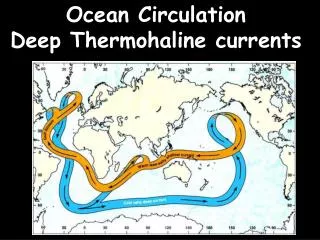
III. Density Currents A. Denser water will sink below water of lesser density B. Water at bottom of all world’s oceans originates at poles 1. Antarctic water has slightly higher salinity than Arctic Ocean water 2. Pole water possesses a lower salinity than tropical water, but it is denser because of its colder temperature
Cross-section of Atlantic Ocean Nybakken, 2001, p. 16
IV. Thermocline A. Defined: Sharp gradient (= change) in temperature as depth increases B. How it is formed in open ocean 1. Surface of ocean is heated by sun, thus it is significantly lighter than deeper oceanic water 2. Winds mix upper 200 m (= “mixed layer”) of surface water