Download
1 / 17
170 likes | 323 Views
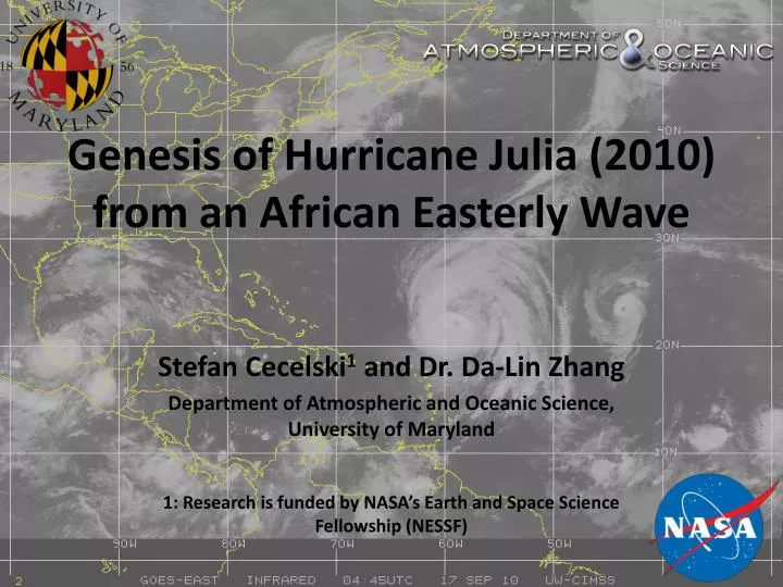
Genesis of Hurricane Julia (2010) from an African Easterly Wave. Stefan Cecelski 1 and Dr. Da -Lin Zhang Department of Atmospheric and Oceanic Science, University of Maryland 1: Research is funded by NASA’s Earth and Space Science Fellowship (NESSF). What is tropical cyclogenesis (TCG)?.

E N D
Genesis of Hurricane Julia (2010) from an African Easterly Wave Stefan Cecelski1 and Dr. Da-Lin Zhang Department of Atmospheric and Oceanic Science, University of Maryland 1: Research is funded by NASA’s Earth and Space Science Fellowship (NESSF)
What istropical cyclogenesis (TCG)? • The point at which a tropical disturbance over the ocean starts intensifying; • Genesis is also defined from the National Hurricane Center (NHC) when it declares a system a tropical depression (TD); • Once genesis takes place, the disturbance can sustain itself (and even intensify) through wind-induced surface heat exchange (WISHE)
Large-Scale Environmental Conditions • Weak vertical wind shear over the depth of the troposphere (between 850 and 200 hPa); • Sea-surface temperatures (SSTs) greater than 26°C; • Sufficient moisture in the lower and middle troposphere
The Role of the African Easterly Wave (AEW) in TCG • An AEW is a wave that propagates westward across Africa; • Latitudinal formation is typically confined between 5 and 20 N; • Cyclonic circulation is maximized between 850 and 500 hPa; a mid-troposphere phenomena • AEWs are the most common path way for TCG in the main development region of the North Atlantic basin • The AEW allows for a favorable environment for TCG; • Protects the developing disturbance from dry air, large vertical wind shears; • Provides a “sweet spot” for growth of a pre-genesis disturbance, the so-called marsupial paradigm(Dunkerton et al. 2009 and Montgomery 2010)
Bottom-Up Formation Vorticity Development during TCG: Two Major Theories Top-Down Formation Low-level vorticity is spun up from the top downto the surface A mesoscale cyclonic vortex is extended toward the surface via precipitation/evaporative cooling Found to be ineffective in creating the near-surface circulation Low-level cyclonic vorticity exists in large scales (meso-α) and is spun up and contracted Convective elements (meso-β scale) enhance the cyclonic vorticity; the idea of a Vortical Hot Tower (VHT) Meso-β features are thought to aggregate to create the low-level cyclonic vortex
Figure from Houze, et. al (2009) (a): An individual VHT that can help make an MCS. Vorticity of the low-levels is stretched via convergence in the updraft (b): VHTs become apart of a longer-lived MCS, which forms a stratiform region from the weakening VHTs. (c): Weakening stage of MCS, VHT formation ceases. (d): Shows life-cycle of MCS from VHT to MCS. MCV: Mesoscale Convective Vortex MCS: Mesoscale Convective System VHT: Vortical Hot Tower
Where my research fits in • The large-scale characteristics associated with TCG are well known…but what about the role of smaller features? • Features with horizontal lengths from 10 km to 500 km (meso-γ and meso-β structures); “Vortical hot towers” • Convection on the meso-γ and meso-β spatial scale is important for genesis via vorticity generation • Multi-scale interactions exist between smaller scale convective features and the larger scale environment
Methodology • Use the Weather and Research Forecasting (WRF) numerical weather prediction model to simulate Julia’s development • Due to limited observing networks, need some way to assess the dynamics at a high spatial resolution • WRF simulation is compared against the limited observations we have to validate its accuracy
Objectives • Examine the genesis of Julia from the merging of several meso-β-scale vortices within the AEW; • Study how deep convection, invigorated through a high θe and storm-relative helicity (SRH) environment, contributes to the development of the meso-β-scale vortices; • Show that the vorticity maxima (and related convection) lies on the critical level (latitude) Dunkerton, et al. 2009, the latitude where the wind speed equals the phase speed of the AEW)
WRF Model Set-up NOAA Optimal Interpolation SSTs (shaded, degrees C), 700-hPa Streamlines (resting frame) from ERA-Interim for the initialization time of the WRF simulation.
WRF Validation TD Average PMIN error from observed was 1.67 hPa. Track errors had substantial more latitudinal error than longitudinal.
WRF Outgoing Longwave Radiation (OLR, shaded, white/gray low OLR) and 700-hPa wind barbs METEOSAT-9 IR Imagery with satellite-derived winds 400-599 hPa (blue) 600-799 hPa (yellow) 800-950 hPa (green) Julia
Transition from AEW to Julia 925-hPa co-moving streamlines, relative vorticity (shaded) and MSLP (red contours, every 1 hPa). Black line represents hourly-based back-trajectory of vorticity center that becomes co-located with the AEW circulation center. The AEW trough axis at 3 times is superimposed, with the black-dashed line being the current time trough axis. The critical latitude is shown with a dotted line. 925-hPa Radar reflectivity (shaded) relative vorticity (contours), co-moving streamlines and the critical latitude (dashed line) 6 hours prior to 0600 UTC 12 Sept How did it strengthen over the 6-hour period?
925-hPa Radar reflectivity (shaded), relative vorticity (contours), co-moving streamlines and critical latitude (dashed line) 925-hPa Theta-e (shaded), 0-3km Storm-relative helicity (contours), co-moving streamlines and critical latitude (dashed line)
925-hPa Radar reflectivity (shaded), relative vorticity (contours), co-moving streamlines and critical latitude (dashed line) 925-hPa Theta-e (shaded), 0-3km Storm-relative helicity (contours), co-moving streamlines and critical latitude (dashed line)
Concluding Remarks • While the AEW provides favorable forcing for convective development, merging of meso-β-scale vortices generated in rainbands accounts for the genesis of Julia; • High θeair to the north and west of the storm invigorates convection while ingestion of high sfc-3km SRH aids in cyclonic relative vorticity development at 925 hPa; • As hypothesized by Dunkerton, et al. 2009, the critical latitude provides a preferred region for amplification of meso-β development (their H1); • This low-level cyclonic vorticity development leads to genesis, both through convective enhancement and the critical latitude acting as an ‘attractor’ for meso-β cyclonic vortices