Download
1 / 10
100 likes | 105 Views
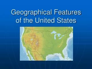
Geographic features that shaped the identity of the United States. US History . Size: 3,700,000 sq miles. 4,000 mile border with Canada. 1,900 mile border with Mexico. Mountain Ranges: Appalachian. 1,500 miles long Runs from New England to Georgia and Alabama.

E N D
Geographic features that shaped the identity of the United States US History
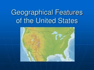
Size: 3,700,000 sq miles 4,000 mile border with Canada 1,900 mile border with Mexico
Mountain Ranges: Appalachian 1,500 miles long Runs from New England to Georgia and Alabama
Mountain Ranges: Rocky Mts. Northern New Mexico to Northern Canada. Continental Divide runs through the Rockies.
Rivers: Mississippi It runs north –south and the delta is very fertile for farming.
Delaware, Hudson, Connecticut and Potomac are shorter rivers located in the East Columbia and Colorado Rivers – west of the Rockies. Flow through desert and semi-arid lands on their way to the Pacific. Dams have been constructed River Systems
St. Lawrence Seaway and canals connect the Great Lakes to the Atlantic. Great Lakes & Seaway Canal • Great Lakes
Great Plains: between the Rockies and Mississippi River. Great PLAINS OHIO R. Valley OHIO RIVER VALLEY- Area that is extremely fertile along the river.
Natural Resources • Gold, silver – set off rushes to California and Alaska • Petroleum, Gas – found in Texas, Louisiana, California and Alaska • coal, copper, lead, zinc and uranium are all mined in the United States.
Geography cause differences • NORTHERN COLONIES- Have a very DIVERSEeconomy based not only on farming but trade and manufacturing. • SOUTHERN COLONIES- Based on the SINGLE CASH CROPS: tobacco, rice, & cotton for export. Used indentured servant then later slaves.