Download
1 / 11
110 likes | 215 Views
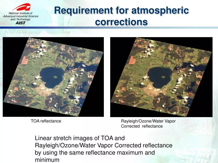
Requirement for atmospheric corrections. TOA reflectance. Rayleigh/Ozone/Water Vapor Corrected reflectance. Linear stretch images of TOA and Rayleigh/Ozone/Water Vapor Corrected reflectance by using the same reflectance maximum and minimum. Surface reflectance and Top of the atmosphere.

E N D
Requirement for atmospheric corrections TOA reflectance Rayleigh/Ozone/Water Vapor Corrected reflectance Linear stretch images of TOA and Rayleigh/Ozone/Water Vapor Corrected reflectance by using the same reflectance maximum and minimum
Surface reflectance and Top of the atmosphere Image from: http://www.profc.udec.cl/~gabriel/tutoriales/rsnote/cp9/cp9-2.htm
Mar. Apr. May Jun. Jul. Aug. Sep. Oct. Nov. Dec. Jan. Feb. TKY TGF MSE RHN PEN Equipments ADFC SP HSSR http://www.pheno-eye.org
Previous System Framework PMS PSS Web Page Input Query DB • Time consuming and need high level user experience. • Lack of Robustness and scalable • Not convenience for sharing among communities PEN Observation System PEN DB & Backup SP ADFC Manipulating (filter, average etc.) HSSR Data Gathering Query value at pixel Validation and Plotting Site B Site D Site C MODIS MOD08 Daily image Correction On developing
OGC System Framework WMS,WMS-T SOS PSS 52NorthSOS Mapserver PEN Observation System SP ADFC Overpass time scene MODIS MOD08 Daily image HSSR GetObservation [During MODIS overpass time from start to end] JSON GetFeatureInfo [MODIS value from start to end] JSON GetObservation ADFC WPS R rpy2 simplejson Etc.. • PyWPS • Validation process • Least Square Fitting process Execute [station,start,end,product] JSON Client
Conclusion • Comprehensive web-based GIS system framework enabled • Based on various open standards of OGC specifications • Using FOSS • Mapserver, 52North SOS, PyWPS • OpenLayers, jQuery, • Assimilation of sensor observation data and satellite image • Wider area, More accuracy, Reasonable cost • Validation of aerosol properties from Satellite estimation with ground based sites • Improve the following product which relied on satellite image “surface reflectance”
Future Development • Increase atmospheric observation network • Skynet • Improving performance • Distributing ground site data source • More than two million records for two station and four years • WMS-T full supported with Mapserver • MOD03 overpass time to MOD08 Global dataset • Possible to error 5 minutes observation • Satellite image product validation • GLEON (Global Lake Ecological Observatory Network) • Lake monitoring : SST, Chl. A : MODIS Ocean product • CO Flux monitoring : Asiaflux / Japanflux • Water Column Correction • CREON (Coral Reef Environmental Observatory Network) • Validation with higher satellite image resolution • ASTER, FOMARSAT