Download
1 / 19
190 likes | 201 Views
Chapter 4. Angles and Directions. 4.2: Reference Direction for Vertical Angles:. Vertical angles: angle which used in slope distance corrections or in height determination Vertical angle are referenced to the: (1) the horizon by plus (up) or minus (down) angles. (2) zenith. (3) nadir.

E N D
Chapter 4 Angles and Directions
4.2: Reference Direction for Vertical Angles: • Vertical angles: angle which used in slope distance corrections or in height determination • Vertical angle are referenced to the: • (1) the horizon by plus (up) or minus (down) angles. • (2) zenith. • (3) nadir. • - Zenith and nadir are terms describing points on a celestial sphere .
4.3: Meridians: • Meridians: a line on the mean surface of the earth joining the north and south poles. • geographic meridian: is the line formed by the intersection with the earth’s surface of a plane that includes the earth’s axis of rotation. • Magnetic meridians: are parallel to the directions taken by freely moving magnetized needles, as in a compass. • Grid meridians: are lines that are parallel to a grid reference meridian (central meridian).
4.4: Horizontal Angles: • Horizontal angles are usually measured with a theodolite or total station. • For all closed polygons of n sides, the sum of the interior angles equal to (n-2)180ْ . • For all closed polygons of n sides, the sum of the exterior angles equal to (n+2)180ْ . • Example: What is the sum of the interior angles for a five-sides polygon? • (5-2)180 ْ = • (3)(180) = 540ْ
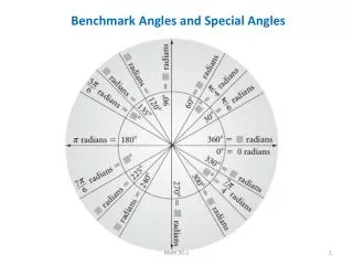
4.5: Azimuths: • Azimuth: is the direction of a line as given by an angle measured clockwise (usually) from the north end of a meridian. • Azimuths range in magnitude from 0ْ to 360ْ .
4.6: Bearings: • Bearing: is the direction of a line as given by the acute angle between the line and a meridian. • Measured clockwise or counterclockwise from the north or south end of the meridian. • Bearing is always accompanied by letters that locate the quadrant in which the line falls (NE, NW, SE, or SW).
4.7: Relationships Between Bearings and Azimuths: • To convert from azimuths to bearings by using this table:
To convert from bearings to azimuths by using this relationships: • NE quadrant azimuth = bearing • SE quadrant azimuth = 180ْ – bearing • SW quadrant azimuth = 180ْ – bearing • NW quadrant azimuth = 360ْ – bearing • Example: convert : • 200ْ 58’ = S20ْ 58’W • N2ْ 21’W = 357ْ 39’
4.8: Reverse Directions: • It can be said that every line has two direction. • Forward direction is direction that oriented in the direction of fieldwork or computation staging. • Back direction is direction that oriented in the reverse of the direction fieldwork or computation staging.
To reverse a bearing … Reverse the direction letters. • Example:
To reverse an azimuth …. Add 180ْ to the original direction. • Example:
4.9: Azimuth Computations: START Az AB = 330ْ 00’ (Given) - 180ْ Az BA = 150ْ 00’ +<B 120ْ 28’ Az BC = 270ْ 28’
Az BC = 270ْ 28’ - 180ْ Az CB = 90ْ 28’ +<C = 118ْ 37’ Az CD = 209ْ 05’ Az CD = 209ْ 05’ - 180ْ Az DC = 29ْ 05’ +<D 105ْ 22’ Az DE = 134ْ 27’
Az DE = 134ْ 27’ + 180ْ Az ED = 314ْ 27’ +<E 108ْ 28’ Az EA = 422ْ 55’ - 360ْ Az EA = 62ْ 55’ Finish Check Az EA = 62ْ 55’ + 180ْ Az AE = 242ْ 55’ +<A 87ْ 05’ Az AB = 330ْ 00’
4.10: Bearing Computation: Line BC: (?)= 180 – (120ْ 28’- 30ْ ) (?)= 89ْ 32’ in N.W quad. i.e., N 89ْ 32’ W Line CD: (?)= 118ْ 37’- 89ْ 32’ (?)= 29ْ 05’ in S.W quad. i.e., S 29ْ 05’ W
Line DE: (?)= 180ْ – (105ْ 22’+29ْ 05’) (?)= 45ْ 33’ in S.E. quad. i.e., S 45ْ 33’ E Line EA: (?)= 108ْ 28’- 45ْ 33’ (?)= 62ْ 55’ in N.E. quad. i.e., N 62ْ 55’ E
Line AB: (?)= 180ْ – (62ْ 55’+ 87ْ 05’) (?)= 30ْ 00’ in N.W. quad. i.e., N 30ْ 00’ W CHECK (Line AB was S 30ْ 00’ E )
4.12: Magnetic Direction: • Magnetic Direction is the horizontal angle between magnetic north and geographic north. • Isogonic chart is line joining points of the earth surface having equal magnetic declination. Geographic Bearing of survey Line = 15ْ 30’+ 10ْ 30’ = 26ْ 00`