Download
1 / 36
440 likes | 676 Views
Introduction to Coastal Navigation. University of Texas Sailing Club. Disclaimer. I am not a certified by ASA, US Sailing, USCG or anyone else to teach this class nor will this class count towards an ASA, US Sailing or USCG certificate. The purpose of this class to inform and familiarize.

E N D
Introduction to Coastal Navigation University of Texas Sailing Club
Disclaimer • I am not a certified by ASA, US Sailing, USCG or anyone else to teach this class nor will this class count towards an ASA, US Sailing or USCG certificate. • The purpose of this class to inform and familiarize
Outline • Before sailing • Reading charts • Understanding symbols • Planning a route • While sailing • Lights & Buoys • GPS • Visual (line of sight) positioning • Dead reckoning • Basic idea of celestial navigation • Right of way
Google Maps Houston Yacht Club Houston Kemah
Google Earth You try to be smart & use a satellite image…
Planning a course Ship Channel Shallow water Shallow water Ship Channel Narrow Channel
Houston Yacht Club What additional information is given? Google Earth NOAA Chart
Kemah There’s a channel? Google Map NOAA Chart
NOAA 11327 – Galveston Bay http://www.charts.noaa.gov/InteractiveCatalog/nrnc.shtml
Understanding Chart Symbols Compass Rose True (geographic north) Magnetic north Correction factor
True vs Magnetic North Source: coastalnavigation.com/
Understanding Chart Symbols LIGHTS • Fl 4s 30ft Priv= Flashing every 4 seconds 30 ft above mean tide. Private light • Q G 23ft “1” = Quick flashing green 23 ft above mean tide. Painted “1”. Private light • F R 12ft Priv= Fixed red 12 ft above mean tide. Private light • Fl R 6s 17ft 4M “2” Ra Ref = Flashing red every 6 seconds 17 ft above mean tide visible for 4 miles. Painted “2”. Radar reflective • G “1” Ra Ref = Green buoy painted “1”. Radar reflective
Understanding Chart Symbols OBSTRUCTIONS Submerged Visible from surface All sorts of fun stuff Partly Submerged Wreck
Understanding Chart Symbols DEPTH Reef Marsh & Shallows Depth in feet (US maps only) Dumping area from dregging
Plotting a Position Fix (PF) Using several reference points to determine your location on a chart.
Plotting a visual fix At 10:40PM, You see a red light flashing every 6 seconds at 217 degrees and a green light flashing every 6 seconds at 137 degrees according to your magnetic compass. Where are you? 20 minutes later, the same red light is at 232 degrees and the green light is at 147 degrees. How fast are you traveling? You continue sailing the same heading. 20 minutes later, the red light is now at 250 degrees and the green light is at 160 degrees. What happened? 2240 2300 2320 2320
Why is this relevant? Heading 320 • You plan to sail the following course from Kemah to the Houston Yacht Club. How do you know when to turn (without being glued to your GPS)? • For example: • Sail along ship channel until past R “2” and G “1” • Turn to heading 030 on your compass; pointed at the G Radar Reflective Mark (bad example) • When the 6s Green is on the beam, turn to heading 320 • Once the 2.5s Green is on the beam, turn to heading 270 Heading 030
A running fix When you only recognize one object
NOAA 13233 – Martha’s Vineyard Below Cap Cod in Massachusetts. (beautiful sailing, check it out at some point)
Plotting a Running Fix (R Fix) Using a single reference point and your assumed course to determine your position
Running Fix • It’s hazy out, so you can only see Gay Head Light. You are sailing a course of 270 degrees magnetic at 6 knots. • At noon, you sight gay head at 220 degrees. • At 12:10, it is at 180 degrees. • At 12:20, it is at 140 degrees. • Plot your course • Now you change course to 180 degrees. At 12:30, Gay Head is now at 110 degrees. • ??? R Fix 1210 R Fix 1220 R Fix 1230
So, what? • When plotting a course, you need at least one reference point if you keep track of your course • Why? This allows you to notice currents, tides and wind. • What would have happened if the course was pushed east instead of west? R Fix 1210 R Fix 1220 R Fix 1230 R Fix 1230
Distance to the Horizon On the ocean: Where d is in statute miles and h is in feet So if you fall in the water, you can see about a mile In a small boat, where your head is 3 feet off the water, two miles To an elevated coast So a 10 foot dune is visible 6 miles out to sea from 3 feet above the water
Celestial Navigation How stars can guide you
Basic Idea The moon, sun and each star is directly overhead on some point of the planet. Call this point A. (technically the ephemeral point) By measuring the angular distance from directly over you to the object, you know how far away from point A you are. It is really hard to accurately measure direction to the object, so you measure 2+ objects. There is a point on the sphere where these distances ‘intersect’. This is your Celestial Fix. Source: tjradcliffe.com
In 3D Source: wavetothewind.com/ You get a Circle of Position, but if you zoom in, it can be approximates as a Line of Position. Two or more of these intersect to give you your position on the globe. Source: onboardintelligence.com/
How do you measure angles? With a sextant Originally developed by Sir Isaac Newton in the late 1600s (as an octant) Refined to it’s current form in the 1757 Required accurate time keeping – lead to the development of the chronograph (1816)
Plotting the fix The more stars you measure, the more accurate your fix becomes (hopefully). A lot of spherical trigonometry (or tables in the form of the Nautical Almanac) is needed. See me offline if you want more information.
How GPS works Simply the intersection of spheres of position to give you (x,y,z) Source: education.nationalgeographic.com/
Right of Way Who yields? Horns
Do you need to change course? If you see green, ALL CLEAR Just keep an eye on the ship – he may not see you If you see red, BE READY TO YIELD Determine if a collision may occur (compass bearings) If relative compass bearing is approaching your heading, YIELD If go away from your heading, ALL CLEAR If you see white, If it is the stern light, ALL CLEAR If a mast head light, FIND THE RED OR GREEN Make any course changes APPARENT Is a collision imminent?
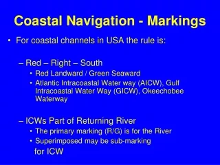
Channel Markers Keep right in virtually all marked shipping channels in the US unless otherwise noted. ALWAYS check the chart before heading into a channel NEVER attempt to sail along an active shipping channel CHECK tide information before entering a narrow channel ENSURE your boat can go FAST enough Source: watercraft.ohiodnr.gov/
Take aways Always familiarize yourself with a new body of water. What looks sailable on Google Earth may not be so. http://www.charts.noaa.gov/InteractiveCatalog/nrnc.shtml Things disappear behind the horizon! A swimmer can see about a mile A small sailboat can see about two miles (or a sand dune on a beach 5 miles away) A boat with its portside to you has the right of way. You have the right of way if you see its starboard side. If you remember nothing else…