Download
1 / 21
210 likes | 367 Views
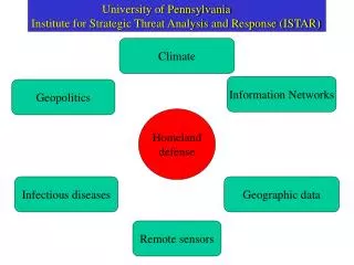
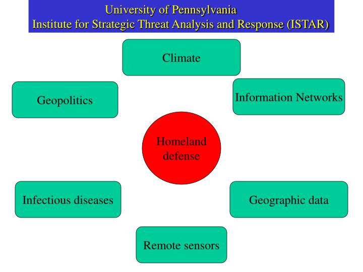
University of Pennsylvania Institute for Strategic Threat Analysis and Response (ISTAR). Climate. Information Networks. Geopolitics. Homeland defense. Infectious diseases. Geographic data. Remote sensors. Contents Foreword — Don de Savigny, Luc Loslier, and Jim Chauvin

E N D
University of Pennsylvania Institute for Strategic Threat Analysis and Response (ISTAR) Climate Information Networks Geopolitics Homeland defense Infectious diseases Geographic data Remote sensors
Contents • Foreword — Don de Savigny, Luc Loslier, and Jim Chauvin • Preface — Don de Savigny, Lori Jones-Arsenault, and Pandu Wijeyaratne • Context • The present state of GIS and future trends — Steven Reader • GIS from a health perspective — Luc Loslier • Spatial and temporal analysis of epidemiological data — Flavio Fonseca Nobre and Marilia Sa Carvalho • Case studies from the South • Towards a rural information system — David le Sueur, Sipho Ngxongo, Maria Stuttaford, Brian Sharp, Rajendra Maharaj, Carrin Martin, and Dawn Brown • A GIS approach to the determination of catchment populations around Local Health Facilities in Developing Countries — H.M. Oranga • GIS management tools for the control of tropical diseases: applications in Botswana, Senegal, and Morocco — Isabelle Nuttall, D.W. Rumisha, T.R.K. Pilatwe, H.I. Ali, S.S. Mokgweetsinyana, A.H. Sylla, and I. Talla • The use of low-cost remote sensing and GIS for identifying and monitoring the environmental factors associated with vector-borne disease transmission — S.J. Connor, M.C. Thompson, S. Flasse, and J.B. Williams • GIS for the study and control of malaria — Gustavo Bretas • Spatial analysis of malaria risk in an endemic region of Sri Lanka — D.M. Gunawardena, Lal Muthuwattac, S. Weerasingha, J. Rajakaruna, Wasantha Udaya Kumara, Tilak Senanayaka, P. Kumar Kotta, A.R. Wickremasinghe, Richard Carter, and Kamini N. Mendis • Diagnostic features of malaria transmission in Nadiad using remote sensing and GIS — M.S. Malhotra and Aruna Srivastava • Monitoring zoonotic cutaneous leishmaniasis with GIS — L. Mbarki, A. Ben Salah, S. Chlif, M.K. Chahed, A. Balma, N. Chemam, A. Garraoui, and R. Ben-Ismail • Use of RAISON for rural drinking water sources management — C.W. Wang http://www.idrc.ca/acb/showdetl.cfm?&DID=6&Product_ID=495&CATID=15
Climate and Satellite Indicators to Forecast Rift Valley Fever Epidemics in Kenya Kenneth J. Linthicum, 1* Assaf Anyamba, 2* Compton J. Tucker, 2 Patrick W. Kelley, 1 Monica F. Myers, 2 Clarence J. Peters 3 The bestfit to the RVF outbreak data was achieved when equatorial Pacificand Indian Ocean SST and NDVI anomaly data were used together. These data could have been used to successfully predict each ofthe three RVF outbreaks that occurred between 1982 and 1998 withoutpredicting any false RVF events for an overall prediction of riskof 100%. Predictive models that use either SOI and Indian Oceanor NDVI and Indian Ocean anomaly data would have predicted allthree RVF events but falsely predicted either one or two diseaseevents, respectively. • Science. 1999 Jul 16;285(5426):397-400.
New initiatives Global and local syndromic surveillance—human and animal Genomic characterization of species and strains of organisms Global and local micro-organism surveillance Distributed sensors Massively networked information systems Education
Research/Education Agenda Dynamic Integration and Analysis of Data Sets Data Geographic Syndromic Microorganisms Climate Political alignments—state and non-state Technology--theory Sensors—hybrid systems Network communication—artificial intelligence Security—authentication, privacy Conflict—asymmetric, multi-agent game theory Education (K-12) undergraduates graduate and professional students practitioners Policy