Download
1 / 31
440 likes | 765 Views
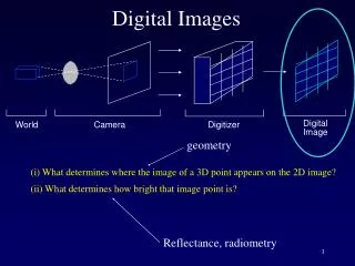
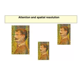
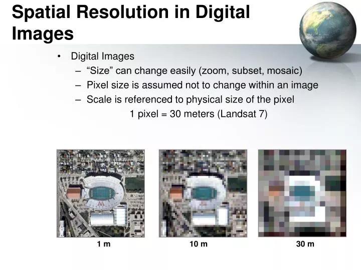
Digital Images “Size” can change easily (zoom, subset, mosaic) Pixel size is assumed not to change within an image Scale is referenced to physical size of the pixel 1 pixel = 30 meters (Landsat 7). Spatial Resolution in Digital Images. 1 m. 10 m. 30 m. 4 Resolutions of Rasters. Spatial:

E N D
Digital Images “Size” can change easily (zoom, subset, mosaic) Pixel size is assumed not to change within an image Scale is referenced to physical size of the pixel 1 pixel = 30 meters (Landsat 7) Spatial Resolution in Digital Images 1 m 10 m 30 m
4 Resolutions of Rasters • Spatial: • X and Y resolution (10 cm to 1 km) • Spectral: • 3 for photos, 7 Landsat, 256 MODIS • Temporal: • Daily for MODIS, 15 days for Landsat, every few years for SRTM • Radiometric: • 8 bits=0 to 255 (256 shades)
4 Resolutions of Rasters Radiometric Resolution + Temporal
Geo-Referenced Raster • Known Projection and Datum (X1,Y1) (X4,Y4) (X2,Y2) (X3,Y3)
Geo-Referenced Raster • Known Projection and Datum • Width and height of a pixel in map units (X1,Y1) Height in pixels Width in Pixels
Geo-Referenced Raster • Known Projection and Datum (X1,Y1) (X3,Y3)
What’s Wrong with this Picture? • Elevation data for the intertidal zone of the Gulf of Mexico
“No-Data” or NULL Values • Rasters are always rectangular • No-Data values are “transparent” and are not used for calcualations
NoData • Background: Bathymetry (depth) of the Gulf (black areas are NoData) • Red is adult shrimp habitat with all other areas “masked” out as “NoData”
Continuous vs. Categorized • Continuous: • Like photographs • Satellite and aerial photos • Best for analysis • Categorized or discrete • Land Cover • Eco-regions • Limited analysis • Careful on precision and accuracy
Categorical vs. Continuous Land cover Digital Elevation Model (DEM)
Raster Sources • Scanned • Topos • Remotely Sensed • Aerial Photos • Satellite Photos • Digital Elevation Models (DEM) • Derived Rasters • Hill shade • Slope • Aspect • Statistical Spatial Analysis
Digital Elevation Model (DEM) Each pixel value is an elevation
Digital Orthophoto Quadrangles (DOQ) • Digial Orthophoto Quarter Quad (DOQQ) • 1 meter aerial photos http://egsc.usgs.gov/isb/pubs/factsheets/fs05701.html
LandSat • 7 Bands • 30m, 15m bw • Entire earth • Twice a month • 26 years of coverage • “Free” • EROS Data Center NASA.gov
National Land Cover Dataset (NLCD) Based on Landsat Imagery 21 Classes based on cover type NLCD for Washington DC
NLCD Coding Scheme • 11 - Open water • 12 - Perennial Ice/Snow • 21 - Low Intensity Residential • 22 - High Intensity Residential • 23 - Commercial/Industrial/Transportation • 31 - Bare Rock/Sand/Clay • 32 - Quarries/Strip Mines/Gravel Pits • 33 - Transitional • 41 - Deciduous Forest • 42 - Evergreen Forest • 43 - Mixed Forest • 51 - Shrubland • 61 - Orchards/Vineyards/Other • 71 - Grassland/Herbaceous • 81 - Pasture/Hay • 82 - Row Crops • 83 - Small Grains • 84 - Fallow • 85 - Urban/Recreational Grasses • 91 - Woody Wetlands • 92 - Emergent Herbaceous Wetlands
Change over time 1992 2006 2001
MODIS Fires smoke and haze over China • 256 Bands • 250m • Entire earth • Twice a day NASA.gov
MODIS Vegetation Continuous Fields, Collection 3 Bare ground Grass/shrubs/moss Percent cover 0% 100% Trees
Derived Rasters Land Cover from satellite and aerial Topography: Slope, aspect, hillshade Ecoregions Suitable Habitat Flood plains Geological Regions
GeoReferenced File Formats • GRID: ESRI’s format • GeoTIFF: Excellent support • MrSID: LizardTech • IMG: ERDAS • ECW: ERMapper • BIL, BIP, BSQ: See header • “ASCII” or “GRID ASCII” (asc) • Lots of others… See: http://www.gdal.org/formats_list.html http://webhelp.esri.com/arcgisdesktop/9.3/index.cfm?topicname=Technical_specifications_for_raster_dataset_formats
World Files • Contains: • X-dimension Pixel size in map units • Y-axis rotation • X-axis rotation • Y- dimension Pixel size in map units (negative) • X-coordinate of upper-left pixel • Y-coordinate of upper-left pixel • Image file contains width and height • TIFF World File: “.tfw” • JPEG World File: “jfw”
ASCII format (asc) • ncols 4 • nrows 6 • xllcorner 0.0 • yllcorner 0.0 • cellsize 50.0 • NODATA_value -9999 • -9999 -9999 5 2 • -9999 20 100 36 • 3 8 35 10 • 32 42 50 6 • 88 75 27 9 • 13 5 1 -9999 See: http://en.wikipedia.org/wiki/Esri_grid
Tagged Image File Format • TIFF • Can be georeferenced (GeoTIFF) • Can tell in ArcCatalog or ArcMap • TIFF w/world file • Also need Projection and Datum (prj?) • Can be compressed • Run-length – Categorical data • LZW – Categorical data • Huffman encoding – Categorical data • JPEG- Continuous data (don’t used on Categorical data!)
JPEG • Joint Photographic Experts Group • Widest used photo format • Can be Georeferened with a world file and a “prj” file • JPEG2000 • Completely new format! • Can be georeferenced • Not really adopted
GRIDS • ESRI’s native raster format • Pyramids • Not an exchange format! • Lots of files, easy to corrupt by moving part of the files (always use ArcCatalog to move these) • Being replaced by “IMG” files?
IMG – ERDAS Imagine • Esri’s new default • Internal geo-referencing • Recommended over Grids