Download
1 / 38
380 likes | 386 Views
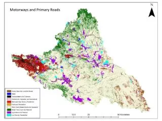
Progetto PON01_01503 Sistemi integrati per il monitoraggio, l’ early warning e la mitigazione del rischio idrogeologico lungo le grandi vie di comunicazione. Discutiamo i risultati. Geological and Hydraulic Safety along Motorways and Railways. EVENT AND RISK SCENARIOS. Pasquale VERSACE.

E N D
Progetto PON01_01503 Sistemi integrati per il monitoraggio, l’earlywarning e la mitigazione del rischio idrogeologico lungo le grandi vie di comunicazione. Discutiamo i risultati Geological and HydraulicSafetyalongMotorways and Railways EVENT AND RISK SCENARIOS Pasquale VERSACE
Challenges and topic for discussions • Communication and dissemination • Some regions do nothing in case of yellow level, neither send forward to municipalities • Others complain of too many yellow and do not like to have 2 separate warning (flood and landslides) • Some municipalities wish to receive directly warnings and not through regions • What to do in the different levels? Authorities start to act only when is red level (not everybody understand that in yellow and orange level damages can occur). • Lack of emergency plans and risk maps (identifying critical areas) • Communication (experts and population) • Avoid too many false alarm, wrong level: yellow orange • Toomanyleaders/politiciansbetweenexperts and population/localauthorities (developingcountriesvsdevelopedcountries)
Eventscenarios Riskscenarios INTERVENTION MODEL Levels of criticality Levels of alert
Eventscenarios • Landslide velocity • Landslide surface • Landslide scarp • Landslide volume • Thickness • Magnitude • Involved material • Occurrence probability Geometric index Properties of expected phenomena
LANDSLIDE SURFACE (SUR) • LANDSLIDE SCARP (SCA)
LANDSLIDE VOLUME (VOL) • THICKNESS (THI)
MAGNITUDE (MAG) • f(GEI, VEL)
INVOLVED • MATERIAL (IM) • OCCURRENCE • PROBABILITY (PRO)
MAP OF EVENT SCENARIOS – level 1 • Perimeter of landslide and propagation zone MAG1 MAG3 MAG2
MAP OF EVENT SCENARIOS – level 2 Normalized value Mud Debris Earth GEI PRO VEL MAG Mixture of components
MAP OF EVENT SCENARIOS – level 3 Normalized value Mud Debris Earth GEI VOL THI SCA MAG SUR PRO VEL Mixture of components
Riskscenarios • Mud and/or debris movements which could induce a friction reduction and facilitate slips
Riskscenarios • Road subsidence induced by landslides that could drag or drop vehicles
Riskscenarios Falls of significant volumes and/or boulders that could crush or cover vehicles and constitute an obstacle for others vehicles
Riskscenarios A hydraulic infrastructures and/or barriers only emergency lane lane fast lane fast lane of the opposite carriageway lane of the opposite carriageway B C 18 riskscenarios
Riskscenarios • Aa • Ab • Ac • Up • Down
Riskscenarios • Ad • Ae • Af • Up • Down
Riskscenarios • Ad • Bd • Cd • Up • Down
Riskscenarios Ca Cb Cc Cd Ce Cf Up Down
Levels of criticality and alert • 4 states: • state 0 (S0) = no variation • state 1 (S1) = small variation • state 2 (S2) = moderate variation • state 3 (S3) = high variation SEN Sensors Model outputs CAED • 2 states: • state 0 (S0) = no variation or not significant • state 1 (S1) = significantvariation IND INDICATORs • Meteorologicaland hydrologicalmodels for vaste areas (for exampleFLaIR model)
Example • SUSHI Model FS (t = t0)
Example • SUSHI Model
Example • 4 states: • State 0 (S0) = no variation • state 1 (S1) = small variation • state 2 (S2) = moderate variation • state 3 (S3) = high variation
RADAR Example
SCATTEROMETER Example
Levels of criticality and alert • 4 states: • state 0 (S0) = no variation • state 1 (S1) = small variation • state 2 (S2) = moderate variation • state 3 (S3) = high variation SEN • Criticalitylevels • ordinary criticality(level 1) • moderate criticality(level 2) • severe criticality(level 3) Sensors Model outputs • 2 states: • state 0 (S0) = no variation or not significant • state 1 (S1) = significantvariation IND INDICATORs • Meteorologicaland hydrologicalmodels for vaste areas (for exampleFLaIR model)
Levels of criticality and alert CAED CCC
Progetto PON01_01503 Sistemi integrati per il monitoraggio, l’earlywarning e la mitigazione del rischio idrogeologico lungo le grandi vie di comunicazione. Discutiamo i risultati The end Geological and HydraulicSafetyalongMotorways and Railways EVENT AND RISK SCENARIOS Pasquale VERSACE