Download
1 / 6

E N D
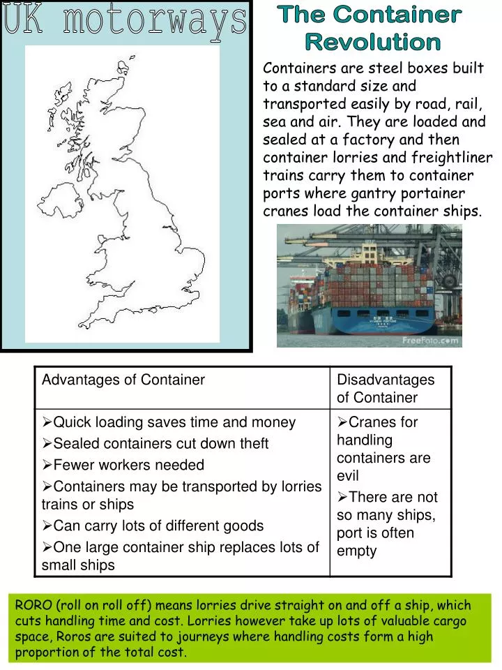
UK motorways The Container Revolution Containers are steel boxes built to a standard size and transported easily by road, rail, sea and air. They are loaded and sealed at a factory and then container lorries and freightliner trains carry them to container ports where gantry portainer cranes load the container ships. RORO (roll on roll off) means lorries drive straight on and off a ship, which cuts handling time and cost. Lorries however take up lots of valuable cargo space, Roros are suited to journeys where handling costs form a high proportion of the total cost.
The Channel Tunnel London to Maidstone to Ashford to Folkestone via rail or M20. Channel Tunnel to Calais. Rail to Lille and Paris, or via motorway. • The channel tunnel was necessary because: • Increased trade with Europe since the growth of the EU • Decrease in trade links with America • Growth of road transport • Growth of East coast ports The tunnel was built in 1994 to carry both passenger and freight line trains. It was built on almost the shortest route to keep costs down, and built through chalk marl, an impermeable clay which is soft and easy to tunnel through. Dover The hinterland of a dock is the total area served by a dock. The hinterland of Dover covers most of the UK, and most people travel by motorway, because it is fast, there are direct links between cities, large areas of the country are covered by the extensive network, and there is less congestion and delays. Dover is located on the South East Coast of England, accessed by the M2 and M20, opening the port up to the rest of the UK. Dover is the busiest port in the UK. In 1999, there were 18.2 million passengers, 3.3million cars, 156,000 coaches and 1.5million lorries which passed through Dover. As the tunnel has become more popular, these numbers have reduced.
Roro ferries use Eastern docks. Eastern docks are accessible by road and have large areas for parking while people wait to board. Dover Wellington and Granville Docks – marinas or closed docks Pleasure boats sail from the Western dock, they are kept away from ships so they don’t cause delays. Two cruise ship terminals Containers are often loaded and unloaded using cranes, which means fewer workers and a faster turnaround. The container ships import/export a range of goods, like fruit.
4 types of ship handled; bulk cargo, container, ro-ro and tankers. 35 cranes a;ong 8km quayside Handles 4.2 million containers every year. Rotterdam • Site • Rotterdam is built at the mouth of the river Rhine • Old town centre is 20km inland and has grown Westwards • Located on North section of Rhine delta • Much of city has been built on reclaimed, marshy land below sea level • Rhine and Maas both enter sea at Rotterdam meaning a large waterfront and new harbours can easily be dug out of the soft alluvium. • Situation • Rotterdam is at the mouth of the Rhine drainage basin and has road, rail and canal to other European countries; R.Meuse to France, R.Mosel through Luxembourg, R. Maine and R. Neckar to Germany. Excellent communications because it is designated EU port. • The growth of Rotterdam: • Rotterdam is the largest cargo port in the world; • Large industrialised hinterland including Netherlands, Belgium, Germany, Switzerland, Luxembourg, France. 80 million people in the hinterland, one of the most densely populated areas of the world, creates huge demand. Hinterland has been increased by the Danube/Main canal and the Rhone/Moselle canal. • Industrial regions like Ruhr and Frankfurt require large amounts of bulky raw materials, like iron ore. Navigable rivers like the Rhine allow the 7000 tonne ships to navigate to the areas carrying these products cheaply. • Rotterdam is a break of bulk point: 100,000 tonnes of oil can be carried to Rotterdam by ship, then refined and the many smaller products can be taken to other ports. Links to the Hinterland 1. Ships – large ocean going vessels move along lower river and North Sea 2. Barges – move along dense network of towards Basle, and finished products downstream. canals and rivers. Move raw materials upstream 3. Roads – lighter goods moved in containers. Dense motorway network connects to all surrounding countries. EU has meant fewer border formalities and increase in use. 4. Rail – electrified links to Brussels Amsterdam and Ruhr enables rapid access favouring containers. 5. Pipelines – oil and products are piped to Ruhr and Cologne areas. Pipeline to Groningen in North Netherlands supplies gas in bulk to industrial units at Rotterdam.
Rotterdam Maasvlakte opened in 1974 which allows access directly to the North Sea, on reclaimed land. Deep enough for largest vessels. Bulk handling port for coal and containers. Also has liquid gas plant and oil terminal. Rotterdam – original sheltered harbour. No longer commercially used. Urban redevelopment similar to Liverpool with marinas for small leisure craft. Botlek – opened 1957 for shipbuilding and repairs. Also for roro ferries with excellent motorway links. Maasvlakte II currently under construction Europoort opened in 1964 as a break of bulk point with oil terminals, oil refineries and chemical works, also containers. Eemhaven – opened in 1946 next to new waterway, originally for traditional cargo • Main industries at Rotterdam: • Oil refinery • Oil storage • Petrochemicals • Coal and iron ore storage • Ship building • Engineering • Vegetable oil processing • Food processing
Flooding at Rotterdam • From the Sea – Causes • Storm in the North Sea with a low pressure causing tidal surge of up to 3m. If the sea is also wind driven, the surge may be higher. Solution • Gates to the north Sea which are controlled by the BOS computer, which receives constant information on weather patterns and sea conditions. If it predicts that there will be a tidal surge, it closes the gates. It takes 4 hours to flood the dry docks and float them into the sea. • From the Land, Rivers - Causes • extreme rain event, many rivers and tributaries so the flood worsens as it nears the mouth • Snow melt – source of the Rhine is in the Alps, snowmelt flows downstream • Development of agriculture in upper basin and building of impermeable structures on flood plains Solutions making problems worse • Straightening meanders – allows ships to travel faster but also allows water to travel faster, so the Dutch have little time to prepare • Building on floodplains, removing natural flood basins • Modern Solutions • Flood meadows – block the river at a point and allow to flood surrounding land, lowering water level in river • Wing dykes – create turbulent water to slow the flow down • Flood defences for building – removable metal walls • Block straight channels to slow water down • Work with EU partners to increase forestation, increasing interception and reducing speed of run-off.