Download
1 / 29
300 likes | 526 Views
Developing a Reference Crop Evapotranspiration Climatology for the Southeastern U.S. using the FAO Penman- Monteith Estimation. Heather Dinon *, Ryan Boyles, Gail Wilkerson Carolinas and Virginia Climate Conference October 21, 2009 Wilmington, NC. Motivation.

E N D
Developing a Reference Crop Evapotranspiration Climatology for the Southeastern U.S. using the FAO Penman-Monteith Estimation Heather Dinon*, Ryan Boyles, Gail Wilkerson Carolinas and Virginia Climate Conference October 21, 2009 Wilmington, NC
Motivation • Weather/Climate Agriculture/Irrigation • NC Agriculture: • Annual $71B economy • 19% of state income • Over 16% of work force • (NCDA&CS 2008) • Agriculture is largest consumer of water in US (NOAA 2002) Photo courtesy of Bridget Lassiter, of NCSU Crop Science Department
What is this? Why do we need? Robust ET estimate: Efficient water use Maximize yields http://science.howstuffworks.com/trees-affect-weather.htm/printable
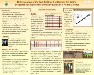
Introduction • ET provides guidance for crop management • Limited ET observations • Solution: UN FAO Penman-Monteith method to estimate daily reference crop ET • Theoretical grass reference crop • Height of 0.12m • Albedo of 0.23 • Surface resistance of 70s/m • Weekly irrigation schedule • Min/Max Temp, Min/Max RH, Avg SR, Avg WS • Dependent on time of year & location (elev, lat)
Daily estimation • Calculates RefET for stations on selected date of interest (YY-MM-DD) • Date range: 01 Jan 2002 - yesterday • ASOS, AWOS, ECONET, RAWS, USCRN • Virginia, Carolinas, Georgia, Florida, Alabama
Climatology product • Years: 2002-2008 • Daily average: 7-day moving average • Annual time series for each station • Average monthly totals • Annual bar chart for each station • Both products require >80% of data, and data must pass QC checks
*Note: Upper and lower boundaries capture ~50% of the distribution. Only shown if 5 or more years of data.
Sensitivity analysis • Sensitivity of inputs: • min/max temp, min/max RH, avg SR, avg WS • Case study: • Lake Wheeler Field Lab, Raleigh, NC • Elevation: 382 feet above sea level • Station type: ECONET • Average each parameter during July (2002-2008)
Summary - Tool • Dataset of ET for assistance with crop management across Southeast US • Daily estimate (2002 up to yesterday) • Climatology product (daily/monthly) • Spatial (maps) & temporal (graphs)
Summary - Analysis • Direct relationship: SR, temp, WS • Indirect relationship: RH • SR main energy source for ET
Future Work • Analyze trends across the Southeast • Sensitivity analysis of inputs • Spatial variation (regional trends) • Temporal variation (seasonal trends)
Questions? Comments? Contact Information: Heather Dinon hadinon@ncsu.edu 919-515-3056