Download
1 / 38
390 likes | 461 Views
Runoff Estimation, and Surface Erosion and Control. Ali Fares, PhD NREM 600, Evaluation of Natural Resources Management. Runoff Estimation. TR55 CN Method.

E N D
Runoff Estimation, and Surface Erosion and Control Ali Fares, PhD NREM 600, Evaluation of Natural Resources Management
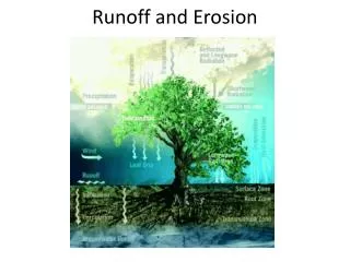
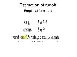
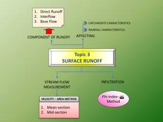
TR55 CN Method • The SCS has developed a method of determining excess rain based on precipitation depth (P). The model developed by the SCS separates precipitation into three categories: • Q - Direct runoff (excess rain) This is the depth (in) of rain that shows up as runoff. • F - Actual retention. This is the depth (in) of the abstraction • Ia - Initial abstraction This is the depth (in) of rain that must fall before runoff starts.
SCS Runoff Equation • Where Q = runoff (in) • P = rainfall (in) • S = potential maximum retention after runoff begins (in) and • Ia = initial abstraction (in)
Ia is all losses before runoff begins it includes: • water retained in surface depressions, • Water interception by vegetation • Evaporation and infiltration. • Ia was found to follow: Ia = 0.2*S
Potential Maximum Retention • S is related to the soil cover conditions of the watershed through the CN. • CN has a range of 0 to 100
The ultimate total retention, S, and the initial abstraction, Ia, are assumed to be dependent on the following properties of the drainage basin: • Land use • Soil Type: A, B, C, D • Soil group A – Well drained sand or gravel, high infiltration rate • Soil group B – Moderately well drained soil, moderate infiltration rate, with fine to moderately coarse texture • Soil group C – Slow infiltration rate, moderate to fine texture • Soil group D – Very slow infiltration, mainly clay material, relatively impervious • Hydrologic condition – good/fair/poor (rural land use only) • Antecedent moisture condition (AMC) • AMC I – Dry soil • AMC II – Average soil moisture • AMC III – Wet soil
Example: Use the graphical solution curve to determine the 100-year, 24-hour depth of runoff for a basin with ½-ac lots on a B soil. Use the 100-year, NRC IDF data for the precipitation depth. • Compute precipitation depth: • CN = 80.0
What’s soil erosion? Erosion is the process of detachment and transport of soil particles by erosive agents (Ellison, 1944) Erosion is a natural geologic process • WATER EROSION • WIND EROSION • TILLAGE TRANSLOCATION
SOIL EROSION IS GLOBAL PROBLEM • 1/3 WORLD’S ARABLE LAND LOST SINCE 1950 • MOST IN ASIA, AFRICA, S. AMERICA • 13-18 t/a/yr • 30% OF US FARMLAND ABANDONED • EROSION • SALINIZATION • WATER-LOGGING • 90% OF US CROPLAND LOSING SOIL FASTER THAN IT IS REPLACED • >1 t/a/yr PIMENTEL ET AL., 1995
SIGNIFICANT SOIL LOSS IN THE USA WATER 3.5 X 10⁹ T/yr WIND 1.5 X 10⁹ T/yr
WIND EROSION SUSPENSION WIND SALTATION CREEP • SALTATION DETACHES PARTICLES • SMALLER PARTICLES SUSPENDED • LARGER PARTICLES CREEP • SANDY AND SILTY SOILS MOST SUSCEPTIBLE • SOIL ACCUMULATION IN DITCHES AND FENCE ROWS
WIND EROSION CAN BE SIGNIFICANT Near Mitchell, SD
Dust bowl • 1931-1939 there was a drought called the “dust bowl”. It caused huge dust storms to erupt that destructed billions of acres of farm land.
storms • In the first year of the drought there were 14 storms reported and the second year there were 38 storms. It was getting worse.
Ruined land • Tons of damage was done to every ones land and it costs billions of dollars to repair the damages.
Black Sunday • April 14th,1934 black Sunday was the worst blizzard of the dustbowl which caused the most extensive damage.
REDUCING WIND EROSION • MAINTAIN SURFACE COVER • CROP RESIDUE • COVER CROPS • INCREASE STUBBLE HEIGHT • INSTALL WINDBREAKS • EFFECTIVE 15x HEIGHT • IRRIGATE • STRIP CROPS PERPENDICULAR TO PREVAILING WIND
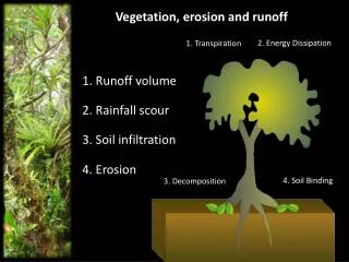
WATER EROSION PROCESS • BEGINS WITH RAINDROPS STRIKING BARE SOIL DISLODGING PARTICLES • INTENSE RAINS SEAL SURFACE • WHEN RAINFALL EXCEEDS INFILTRATION WATER IS STORED IN SMALL DEPRESSIONS • ONCE DEPRESSIONS ARE FILLED, RUNOFF BEGINS
WATER EROSION PROCESS • Initially water flows in a discontinuous sheet • Eventually it concentrates into small channels or rills. The runoff now has energy to break off particles and cut deeper • The amount of erosion caused by sheet and rill erosion increases with slope and distance • Rills may eventually form gullies
EFFECTS ON ENVIRONMENTAL QUALITY AND PRODUCTIVITY • LOSS OF OM, CLAY, AND NUTRIENTS REDUCES PRODUCTIVITY • DAMAGE TO PLANTS • FORMATION OF RILLS AND GULLIES AFFECTS MANAGEMENT • SEDIMENTATION IN WATERWAYS, DIVERSIONS, TERRACES, DITCHES • DELIVERY OF NUTRIENTS TO SURFACE WATER