Download
1 / 59
1.11k likes | 1.76k Views
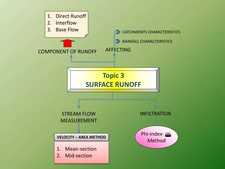
Direct Runoff Interflow Base Flow. CATCHMENTS CHARACTERISTICS. RAINFALL CHARACTERISTICS. AFFECTING. COMPONENT OF RUNOFF. Topic 3 SURFACE RUNOFF. INFILTRATION. STREAM FLOW MEASUREMENT. Phi-index- Method. VELOCITY – AREA METHOD. Mean-section Mid-section. INTRODUCTION.

E N D
Direct Runoff • Interflow • Base Flow CATCHMENTS CHARACTERISTICS RAINFALL CHARACTERISTICS AFFECTING COMPONENT OF RUNOFF Topic 3 SURFACE RUNOFF INFILTRATION STREAM FLOW MEASUREMENT Phi-index- Method VELOCITY – AREA METHOD Mean-section Mid-section
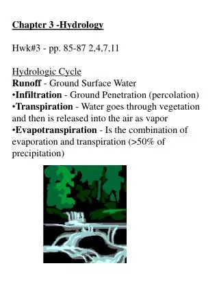
INTRODUCTION • If the amount of water falling on the ground is greater than the infiltration rate of the surface, runoff or overland flow will occur. Runoff specifically refers to the water leaving an area of drainage and flowing across the land surface to points of lower elevation. Runoff flowing into a stormwater drain
COMPONENT OF RUNOFF Water used by plants and returned to the atmosphere Water evaporated directly from surface puddles Transpiration Evapotranspiration Evaporation Water retained by the soil Soil water water running on the surface Overland flow Direct runoff Water flowing underground but feeding the water course Interflow Groundwater accreditation • Water lost to groundwater
Direct Runoff/ Overland Flow • Water that flows over the ground surface or through the ground directly into streams, rivers, and lakes. • Direct runoff originally from excess rain. Direct runoff magnitude and excess rain is the same
Interflow • interflow is the lateral movement of water that occurs in the upper part of the unsaturated zone, or vadose zone, that directly enters a stream channel or other body of water without having occurred first as surface runoff (as with throughflow).
Base flow • Base flow (also called drought flow, groundwater recession flow, low flow, and sustained or fair-weather runoff) is the portion of stream flow that comes from "the sum of deep subsurface flow and delayed shallow subsurface flow". It should not be confused with groundwater flow. • is the sustained flow (amount of water) in a stream that comes from groundwater discharge or seepage. • Stream discharge derived from groundwater sources as differentiated from surface runoff.
Catchments Area • The area of land draining in to a stream or a water course at a given location is called catchment area / drainage area / drainage basin / watershed. • A catchment area is separated from its neighboring areas by a ridge called divide / watershed. • A watershed is a geographical unit in which the hydrological cycle and its components can be analyses. The equation is applied in the form of water-balance equation to a geographical region, in order to establish the basic hydrologic characteristics of the region. Usually a watershed is defined as the area that appears, on the basis of topography, to contribute all the water that passes through a given cross section of a stream.
Watershed and watershed divide Watershed/ catchment Watershed/ catchment Watershed divide
Measuring the components of catchment hydrology • Historically, catchment studies adopted a water balance approach • P = Q + E + I + Δ (M, G, S) • P is precipitation, Q river discharge, E evapotranspiration, I interception, M soil water storage, G groundwater storage and S is channel and surface water storage • Seasonal variations in the balance control seasonal patterns in river flow • However - simple input/output ratio does not explain processes • Need to evaluate the role of runoff production processes in generating river flow
CATCHMENT CHARACTERISTICS AFFECTING DIRECT RUNOFF • Catchment’s Area (size) • Shape • Altitude • Topography • Geology (soil type) • Catchment Area Gradient • Catchment Orientation • Average Annual Excess Rainfall • Stream Frequency • Base Flow Index • Lake Area And Reservoir • Soil Humidity Rate • Land used (vegetation) • Type of drainage network • Proximate to ocean and mountain range
Catchment Area Physical Factor Also need to consider the storm duration and time of concentration.
RAINFALL CHARACTERISTICS AFFECTING DIRECT RUNOFF Type of precipitation and season Rainfall Depth Rainfall intensity Rainfall Duration Rainfall arial distribution Storm Direction of motion Rainfall Frequency Antecedent precipitation
RAINFALL CHARACTERISTICS AFFECTING DIRECT RUNOFF 1. Types of Precipitation: It has great effect on the runoff. E.g. A precipitation which occurs in the form of rainfall starts immediately as surface runoff depending upon rainfall intensity while precipitation in the form of snow does not result in surface runoff. 2. Rainfall Intensity: If the rainfall intensity is greater than infiltration rate of soil then runoff starts immediately after rainfall. While in case of low rainfall intensity runoff starts later. Thus high intensities of rainfall yield higher runoff. 3. Duration of Rainfall: It is directly related to the volume of runoff be cause infiltration rate of soil decreases with duration of rainfall. Therefore medium intensity rainfall even results in considerable amount of runoff if duration is longer.
RAINFALL CHARACTERISTICS AFFECTING DIRECT RUNOFF 4. Rainfall Distribution: Runoff from a watershed depends very much on the distribution of rainfall. It is also expressed as “distribution coefficient” mean ratio of maximum rainfall at a point to the mean rainfall of watershed. There fore, near outlet of watershed runoff will be more. 5. Direction of Prevailing Wind: If the direction of prevailing wind is same as drainage system, it results in peak low. A storm moving in the direction of stream slope produce a higher peak in shorter period of time than a storm moving in opposite direction 6. Other Climate Factor: Other factors such as temperature wind velocity, relative humidity, annual rainfall etc. affect the water losses from watershed area.
STREAM FLOW MEASUREMENT Stream discharge can be measured using; (1) Volumetric Gauging (buckets) (2) Float Gauging, (3) Current Metering, (4) Dilution Gauging (Constant Injection Or Salt Gulp Methods), (5) Structural Methods (weirs, notches, orifices & flumes) • Slope-area Methods. • Rating Curve The choice of method depends on the characteristics of the stream and on the application. Indirect method
Flow estimation: Buckets: Limitations • Only useful for flows <20l/s • Whole flow must be channelled to the bucket
Flow estimation: Float Suitable for straight channel, V = L/T
Flow estimation: Float: Limitations • Average flow can only be inferred from flow at surface • The stream bed should not have any significant changes over the test length • Needs a good approximation of the stream bed shape – which can be tedious
Flow estimation: Weirs: Calculation for rectangular weirs b>3h >2h >2h h H
Flow estimation: Weirs: Calculation: Weir coefficients for rectangular weirs
Flow estimation: Weirs: Calculation for triangular weirs b >2h >2h h
Flow estimation: Weirs: Calculation: Weir coefficients for triangular weirs
Flow estimation: Weirs: Limitations • An initial flow estimate is required to ensure the notch is an appropriate size • The weir must be perfectly sealed • Permanent weirs are costly • Even a temporary weir can be problematic and time consuming to construct
Flow estimation: Staff gauge: Limitations • Needs a good approximation of the stream bed shape which must remain valid – erosion/siltation will effect the validity of measurements • Only valid for comparing flows over time – an initial flow reading must be taken by another method • “weir coefficients” will change with water height
Flow estimation: Current meters • Current meters • Cup-type (Price and pygmy) • Propeller type • Inductance • V = a + bN • where V = flow velocity; • a = starting velocity to overcome mechanical friction; • b = equipment calibration constant; • N = revolutions/sec
Flow estimation: Current meters Cup-type Propeller type Inductance
Flow estimation: Current meters: Limitations • Needs a good approximation of the stream bed shape • Cost? • Fragility?
Flow estimation: Salt gulp: Limitations • Automated equipment can be expensive – non automated procedure is complex • Needs skill to take readings and interpret duff ones • Errors may not be apparent unless maths is done on-site
Velocity – Area method • Determination of cross-sectional area of stream • Estimation of water velocity (using an impeller meter) multiplied by area of water in a cross section Velocity Distributions
from the water surface Depth < 0.6m ; 0.6 water depth = V V 0.6d + V V 0.2d 0.8d = £ £ V 0.6m Depth 2m 2 + + V 2V V 0.2d 0.6d 0.8d = ³ V Depth 2m 4 Mean Flow Velocity Estimation • Mean Velocity
Exercise 3a:Given V = 0.5N + 0.04 m/ s. Determine streamflow discharge using velocity-area method.
Exercise 3b:Given V = 0.3N + 0.05 m/ s. Determine streamflow discharge using velocity-area method.