Download
1 / 16
160 likes | 279 Views
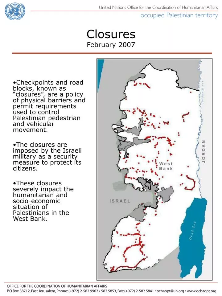
Closures February 2007. Checkpoints and road blocks, known as “closures”, are a policy of physical barriers and permit requirements used to control Palestinian pedestrian and vehicular movement. The closures are imposed by the Israeli military as a security measure to protect its citizens.

E N D
ClosuresFebruary 2007 • Checkpoints and road blocks, known as “closures”, are a policy of physical barriers and permit requirements used to control Palestinian pedestrian and vehicular movement. • The closures are imposed by the Israeli military as a security measure to protect its citizens. • These closures severely impact the humanitarian and socio-economic situation of Palestinians in the West Bank.
0 5 10 Miles Please wait while slide is loading West Bank(5,600 km2),(2,160 mi2) Palestinian Built-up areas in the West Bankpop. 2,444,500PCBS 2006 161 Israeli settlements,96 outposts(285 km2)(110 mi2)pop. 450,000 in 2006 Israeli military closed areas and 27 military bases(1,175 km2)(454 mi2) (As of 5 Oct 2006)
Checkpoint Partial Checkpoint A barrier manned by IDF and/or Border Police with observation towers and other physical blocks used to control pedestrian and vehicular access. An established checkpoint operating periodically.
Trench A ditch dug across or along roads used to prevent vehicle movement.
Road Gate A metal gate used to control Palestinian movement between roads.
Roadblock A series of 1 metre concrete blocks placed across roads used by Palestinians to obstruct vehicle movement.
Earthmound Earthwall A mound of rubble, dirt, and boulders placed in the middle of a road used by Palestinians to obstruct vehicle movement. A series of earthmounds less than 50m apart.
Roadbarrier 2 metre high fencing along West Bank roads which are reserved, generally, forIsraeli traffic. These fences impede Palestinians from using and crossing these roads many of which run between main cities. West Bank Barrier The Barrier is an additional impediment to Palestinian movement. A 703km long complex series of 8-9m high concrete walls, electronic fences, observation towers, trenches, patrol roads and razor wire used to block Palestinian pedestrian and vehicular movement inside the West Bank and East Jerusalem.
Israeli Settlements Israeli Military Closed Areas
“Flying” checkpoints In addition to the several hundred fixed closures, random or “flying” checkpoints further restrict Palestinian movement. 455 of these random checkpoints were observed during January 2007.
Closures UpdateNumber of closures by type ( 11 July 2007) 74 CheckpointsA barrier manned by IDF and/or Border Police. 12 Partial CheckpointsAn established checkpoint operating periodically. 90 Road Gates A metal gate, often manned by IDF, used to control movement along roads. 56 RoadblocksA series of 1 metre high concrete blocks used to obstruct vehicle access. 191 EarthmoundsA mound of rubble, dirt and/or rocks used to obstruct vehicle access. 14 35.9 km TrenchesA ditch used to prevent vehicle crossing. 87 86 km Road barriersRoad barriers placed alongside major roads prevent movement across the roads. 15 15 km Earth WallsA continuous wall or series of earth mounds used to restrict access. 539 TOTAL (11 July 2007)
No real improvement of Palestinian movement in West Bank 710 680 659 605 552 550 539 515 465 376 Jan/04 Jul/04 Jan/05 Jul/05 Jan/06 Jul/06 Jan/07 Jul/07 Total number of checkpoints and roadblocks Disengagement 43% increase since disengagement *Figures include checkpoints and physical obstacles. Data collected by OCHA
Closures and the Humanitarian Situation • Under the 4th Geneva Convention, Israel, as an occupying power may apply security measures for immediate military need and specific threat. • However, the closure system is collectively applied to all Palestinians throughout the West Bank. • For any improvement in the humanitarian and socio-economic situation, the closures must be removed. Photo by OCHA/Steve Sabella
Methods and Credits USE This Power Point Presentation may be used, however, must be accompanied by the date and source. METHODS OCHA oPt has been monitoring the closures since 2003. Our field teams record the obstacles with a GPS unit. These files are used to make maps. The figures are regularly updated. MORE RESOURCES OCHA-oPt documents and maps are available at <www.ochaopt.org> CONTACT Email <ochaopt@un.org> Phone +972 (0) 2582-9962 Close the presentation