Download
1 / 3
30 likes | 113 Views
FROM ST&I UAV PROGRAM ADJUSTMENT QUAD CHART. ACTIVITIES, SCHEDULE & MILESTONES.

E N D
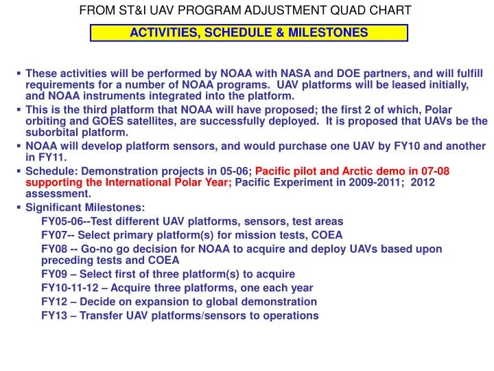
FROM ST&I UAV PROGRAM ADJUSTMENT QUAD CHART ACTIVITIES, SCHEDULE & MILESTONES • These activities will be performed by NOAA with NASA and DOE partners, and will fulfill requirements for a number of NOAA programs. UAV platforms will be leased initially, and NOAA instruments integrated into the platform. • This is the third platform that NOAA will have proposed; the first 2 of which, Polar orbiting and GOES satellites, are successfully deployed. It is proposed that UAVs be the suborbital platform. • NOAA will develop platform sensors, and would purchase one UAV by FY10 and another in FY11. • Schedule: Demonstration projects in 05-06; Pacific pilot and Arctic demo in 07-08 supporting the International Polar Year; Pacific Experiment in 2009-2011; 2012 assessment. • Significant Milestones: FY05-06--Test different UAV platforms, sensors, test areas FY07-- Select primary platform(s) for mission tests, COEA FY08 -- Go-no go decision for NOAA to acquire and deploy UAVs based upon preceding tests and COEA FY09 – Select first of three platform(s) to acquire FY10-11-12 – Acquire three platforms, one each year FY12 – Decide on expansion to global demonstration FY13 – Transfer UAV platforms/sensors to operations
INTERNATIONAL POLAR YEAR • NOAA High Altitude Long Endurance (HALE) UAV program, scheduled to test operations over the Arctic Ocean in 2008. • UAVs can fly to remote locations for up to 24 hours • Routine, in situ observations at fixed points using dropsondes • and on board instruments • Will link land station observations to atmospheric observations • proposed monitoring periods • -Winter • -Melt season • Measurements: • Atmospheric state variables • Chemistry • Forcing