Download
1 / 1
10 likes | 100 Views
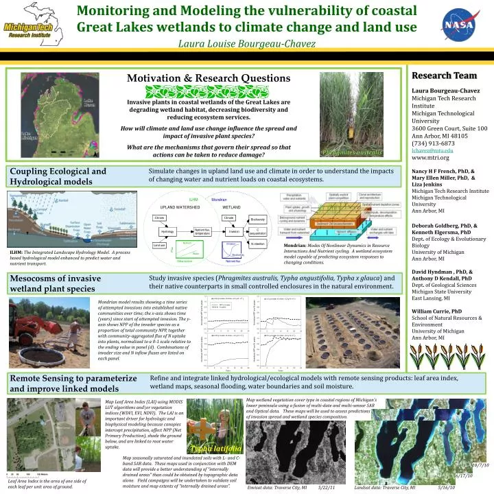
Monitoring and Modeling the vulnerability of coastal Great Lakes wetlands to climate change and land use Laura Louise Bourgeau-Chavez. Research Team Laura Bourgeau-Chavez Michigan Tech Research Institute Michigan Technological University 3600 Green Court, Suite 100 Ann Arbor, MI 48105

E N D
Monitoring and Modeling the vulnerability of coastal Great Lakes wetlands to climate change and land useLaura Louise Bourgeau-Chavez Research Team Laura Bourgeau-Chavez Michigan Tech Research Institute Michigan Technological University 3600 Green Court, Suite 100 Ann Arbor, MI 48105 (734) 913-6873 lchavez@mtu.edu www.mtri.org Nancy H F French, PhD, & Mary Ellen Miller, PhD, & Liza Jenkins Michigan Tech Research Institute Michigan Technological University Ann Arbor, MI Deborah Goldberg, PhD, & Kenneth Elgersma, PhD Dept. of Ecology & Evolutionary Biology University of Michigan Ann Arbor, MI David Hyndman , PhD, & Anthony D Kendall, PhD Dept. of Geological Sciences Michigan State University East Lansing, MI William Currie, PhD School of Natural Resources & Environment University of Michigan Ann Arbor, MI Motivation & Research Questions Invasive plants in coastal wetlands of the Great Lakes are degrading wetland habitat, decreasing biodiversity and reducing ecosystem services. How will climate and land use change influence the spread and impact of invasive plant species? What are the mechanisms that govern their spread so that actions can be taken to reduce damage? Phragmites australis Coupling Ecological and Hydrological models Simulate changes in upland land use and climate in order to understand the impacts of changing water and nutrient loads on coastal ecosystems. Mondrian: Modes Of Nonlinear Dynamics in Resource Interactions And Nutrient cycling. A wetland ecosystem model capable of predicting ecosystem responses to changing conditions. ILHM: The Integrated Landscape Hydrology Model. A process based hydrological model enhanced to predict water and nutrient transport. Mesocosms of invasive wetland plant species Study invasive species (Phragmites australis, Typhaangustifolia,Typha x glauca) and their native counterparts in small controlled enclosures in the natural environment. Mondrian model results showing a time series of attempted invasions into established native communities over time; the x-axis shows time (years) since start of attempted invasion. The y-axis shows NPP of the invader species as a proportion of total community NPP, together with community-aggregated flux of N uptake into plants, normalized to a 0-1 scale relative to the ending value in panel (d). Combinations of invader size and N inflow fluxes are listed on each panel. Remote Sensing to parameterize and improve linked models Refine and integrate linked hydrological/ecological models with remote sensing products: leaf area index, wetland maps, seasonal flooding, water boundaries and soil moisture. Map wetland vegetation cover type in coastal regions of Michigan’s lower peninsula using a fusion of multi-date and multi-sensor SAR and Optical data. These maps will be used to assess predictions of invasion spread and wetland species composition. Map Leaf Area Index (LAI) using MODIS LUT algorithms and\or vegetation indices (WDVI, EVI, NDVI). The LAI is an important driver for hydrologic and biophysical modeling because canopies intercept precipitation, affect NPP (Net Primary Production), shade the ground below, and are linked to root water uptake. Typha latifolia Map seasonally saturated and inundated soils with L- and C- band SAR data. These maps used in conjunction with DEM data will provide a better understanding of “internally drained areas” than could be obtained by topographic data alone. Field campaigns will be undertaken to validate soil moisture and map extents of “internally drained areas”. 10/7/10 6/17/10 Leaf Area Index is the area of one side of each leaf per unit area of ground. Envisat data: Traverse City, MI 5/22/11 Landsat data: Traverse City, MI 5/16/10