Download
1 / 12
120 likes | 217 Views
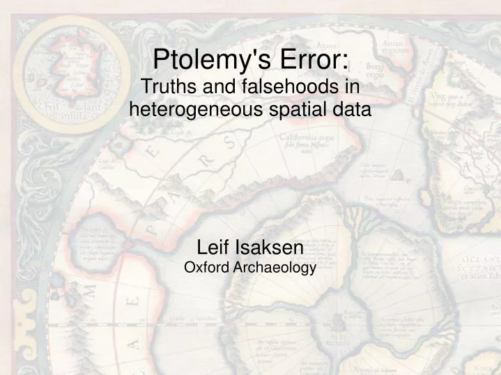
Leif Isaksen Oxford Archaeology. Ptolemy's Error: Truths and falsehoods in heterogeneous spatial data. Ptolemy's World Map. Spatial or textual Data and representation separate – catalogue and instructions Much less potential for error (perhaps) But what about his data quality?.

E N D
Leif Isaksen Oxford Archaeology Ptolemy's Error:Truths and falsehoods in heterogeneous spatial data
Ptolemy's World Map • Spatial or textual • Data and representation separate – catalogue and instructions • Much less potential for error (perhaps) • But what about his data quality?
Ptolemy's Error • Uses 12ths of a degree • But distribution uneven • We know that the source data has varying precision • Problem – we don't know which.
Cautionary Tales • Misconception of point/area data even at standards level • Part of the problem is an oversimplified division – points/lines/polygons or vector vs. raster. TQ125127 TQ1212
The Nature of Historic Mapping • Core Components • Spatial Framework • Entities (points/lines/polygons/cells) • Maps of the Past • Descriptive • Data underdetermines basis of compilation • Truth-standard can be defined as several 'facets' • Strong and weak form • Simple schema
The Categories Incomplete vs. Complete Fuzzy vs. Hard Durée vs. Snapshot Marker vs. Depiction Observed vs. Derived
Incomplete vs. Complete • Incomplete • F iff non-existent entity represented • Complete • F iff non-existent entity represented or existent entity represented • Notes • Even vs. Uneven as special case
Fuzzy vs. Hard • Fuzzy • Vagueness or Imprecision • Vagueness F iff entities which can only be one category are represented as another • Imprecision F iff entity represented outwith boundary of that imprecision • Hard • F iff entity incorrectly categorised, or boundary condition doesn't hold
Durée vs. Snapshot • Durée • F iff not all entities exist within a specified timeframe • Snapshot • F iff not all entities are temporally coexistent at specified timepoint • Notes • Maps of the present are special case of Snapshots
Marker vs. Depiction • Marker • F iff Marker location inaccurate with reference to spatial framework • Depiction • F iff location inaccurate or entity's and object's spatial features don't coincide
Observed vs. Derived • Observed • F iff entity does not correspond to real object • Derived • F iff output doesn't correspond to: function(basedata) • Notes • For Derived to have meaning, both function and basedata need to be referenced.
Questions • Theoretical • Are these facets orthogonal? • Periodic table - Are all combinations permissible? • Interoperability - Are all combinations of combinations useful? • Practical • How can we make these facets transparent? • What potential might they have for supporting data management? • Hard cases?