Download
1 / 19
190 likes | 326 Views
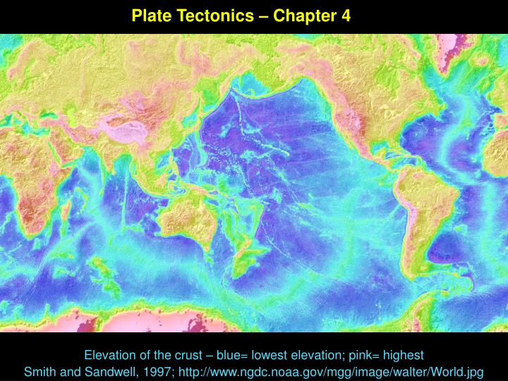
Plate Tectonics – Chapter 4. Elevation of the crust – blue= lowest elevation; pink= highest Smith and Sandwell, 1997; http://www.ngdc.noaa.gov/mgg/image/walter/World.jpg.

E N D
Plate Tectonics – Chapter 4 Elevation of the crust – blue= lowest elevation; pink= highest Smith and Sandwell, 1997; http://www.ngdc.noaa.gov/mgg/image/walter/World.jpg
Plate tectonics is the theory that the Earth's lithosphere (outer rigid shell) is broken into a dozen or so rigid "plates” that move relative to one another on the hotter, more plastic asthenosphere (uppermost mantle). • History - the idea of continental drift • Heat flow and Earth structure – the driving mechanism • Differences between continents and oceans • Evidence for plate tectonics • Types of plate boundaries
Continental Drift – The idea that continents have moved – has been around a long time 1596 Dutch map maker Abraham Ortelius Thesaurus Geographicus “Americas were "torn away from Europe and Africa . . . by earthquakes and floods" … "The vestiges of the rupture reveal themselves, if someone brings forward a map of the world and considers carefully the coasts of the three [continents]. “ Early 1900’s the idea was revived, most notably by Alfred Wegener, who noted similarities in fossils and past climate changes recorded in rocks Die Entstehung der Kontinente und Ozeane (1915) http://pubs.usgs.gov/publications/text/wegener.html The major objection – NO MECHANISM What kind of forces could be strong enough to move such large masses of solid rock over such great distances? Plate tectontics was not accepted until the mechanism was found, in geophysical work after WWII; culminating in the late 1970s 1858, maps by geographer Antonio Snider-Pellegrini http://pubs.usgs.gov/publications/text/historical.html
Wegner’s evidence also included similarities in the rocks and fossils present on the coastal parts of Africa and South America – also, tropical plants (ferns) are found in places now too cold for plant life (Antarctica) http://maritime.haifa.ac.il/departm/lessons/ocean/wwr106.gif
At the end of World War II, increased exploration of the oceans led to better understanding of ocean bottom topography – several features became clear Mid-ocean Ridges – high mountains in the middle of the sea floor Location of deep trenches – at edges of continents Harry Hess (in ‘geopoetry’) proposes sea floor spreading Map by Marie Tharp and Bruce Heezen of sea floor
Lithosphere: cold, outer layer (roughly 100 km thick) rides on hot, ductile asthenosphere (weak layer) Heat flow in lithosphere is by conduction (since it is solid), and heat flow in asthenosphere is by convection Cold lithosphere is brittle and breaks into plates Plate motions are driven by the fact that the Earth’s interior is hot, the result of radioactive decay of isotopes trapped in the interior Fig 4.3, Blue planet
Mechanisms of heat transfer • (1) Conduction – heat transfer through molecular motions in a solid • (2) Convection in liquids or gases ; rising of hot, less dense material and sinking of colder, more dense material, creates currents • (3) Radiation – changing movement of electrons http://www.gcse.com/energy/conduction.htm
Convective motions in the asthenosphere ‘drag’ the plates along; major geologic features of the Earth can be explained by what happens at plate boundariesSea floor created at midocean ridges is destroyed in subduction zones; continents “ride” on moving plates Fig 4.2 Blue Planet
Plate Tectonics was accepted very rapidly as a theory because it explained so many observations – AND made predictions of earth behavior possible Examples: - where volcanoes occur (at the edges of plates) - explanation of where earthquakes occur (also at the edges of plates) -differences in composition and age between continental and ocean crust - the topography of the ocean floor (mid-ocean ridges) - the existence of island chains like the Hawai'ian islands (hot spots) - how mountains ranges are formed (at the collision of two continental plates) - the magnetic record in rocks (which shows apparent polar wandering)
Recent Earthquakes http://www.geophysics.rice.edu/plateboundary/quakes.72.gif
http://www.geophysics.rice.edu/plateboundary/volcano.72.gif Recent Volcanism
How were plate boundaries defined? They are where most earthquakes and volcanoes occur Figure 4.15 in Skinner et al. 1999
Earthquakes also delineated the path of descending plates Where ocean crust was being destroyed Subduction Zones – earthquakes get deeper as the descending slab scrapes against overlying plate Figure 4.14, Skinner et al., 1999
Differences between continent and ocean crust • Continental crust - Thicker (up to 10s of km thick) – Made of less dense materials (granite) • Cannot be subducted into mantle • Generally older, accrete over time • Ocean Crust - Thinner (<10 km thick) – Made of more dense materials (Basalt) • Can be subducted into mantle • Generally younger, gets continuously created and destroyed
Thickness of the Earth ‘s Crust in kilometers; Thickest crust underlies continental mountain belts (or areas compressed by large ice sheets) http://en.wikipedia.org/wiki/Continental_crust
http://www.geophysics.rice.edu/plateboundary/age.72.gif Age of Ocean Crust ( in Millions of Years) Continental rocks are older, averaging ~ 2 Billion years (2000 Million years) oldest crust is 4.1 Billion years
Magnetism Magnetic minerals align themselves in the direction of Earth’s magnetic field when they cool and crystallize Geologists studying paleomagnetism of rocks thought initially that Earth’s magnetic pole was drifting – However, since different continents gave different paths, they realized the continents, not the poles, were wandering Oldest (~500 Million years) http://rst.gsfc.nasa.gov/Intro/Part2_1a.html
Seafloor Spreading Figure 4.13, see also animations for a better idea