Download

1 / 26
290 likes | 532 Views
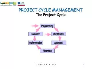
Cycle. Cheng Fu & Kotaro Hara. Do you know where in your city you can bike?. There aren’t many ways to know where you can go with your bike. We make a mobile app that allows cyclists to collaboratively collect data about where they can travel by bicycle. Why do people care?.

E N D
Cycle Cheng Fu & Kotaro Hara
There aren’t many ways to know where you can go with your bike
We make a mobile app that allows cyclists to collaboratively collect data about where they can travel by bicycle
Why do people care? A convenient tool for cyclists as a community to know where they can bike in prior to their trip (*) 1 A tool that can be used by policy-makers, planners, and the public to promote cycling (**) 2 (*) cyclopath.org(**) Winters, M. (2012) Bike Score: Applying Research to Build Web-Based Tools to Promote Cycling
Sparse data! Also, it tells you whereyou can go, but does not inform how nice roads are
There are prototypical solutions such as Geowiki’s where cyclists can collaboratively updateinformation about bicycle accessible routes
Geowiki is nice, but it is hard to attract people to proactively enter data :’(Also, post-hoc reviews are the only way to provide information about how nice paths are How can we make data collection activity more engaging so people want to help us collect data?
We want to make a fun mobile app that people could use while they are biking so we can collect data (bike path locations, road conditions, road aesthetics) in background
Fog of World The app visualizes where the user have and have not visited on a map. It also gives a user badges as they explore the world.
PurplePedals The system locates a position of a bicycle, take a picture, and send it to Flickr. It allows you to track your cycling activity.
We make a Fog of World like app that visualizes where users have and have not been and persuade them to explore the world.We could also monitor information about users’ travel (e.g. how fast you are traveling and how long you have traveled on the day) and give users real-time feedback.
We equipped a bike with an Android phone to collect pictures and other types of data
Back Camera Accelerometer GPS Gyroscope
The area you have traveled becomes visible on the map.A line with variable colorcould visualize different attributes, e.g. how fast youtraveled. The white area with variable transparency represents the area that you have not traveled
StatsView Prototype Speed of a bicycle was calculated by Haversine Formula with GPS coordinates Speed 12 km/h This is a prototype. We completed the backend to get camera preview and other sensor data, but not the interface to show these information
Constantly taking pictures We developed the background program so it can constantly capture pictures. But these pictures were taken manually with the default camera app as our app kept on crashing
Difficulties 1 We realized that a phone screen becomes hard to see if we try to set a pose of a phone so the back camera can capture pictures with good composition.
Difficulties 2 Sampling frequencyHow often should we collect data? And for continuous data (accelerometer and gyroscope), how long should we collect data for each segment?
Future Work Make a UI Utilize data collected from gyroscope and accelerometer for analyzing road conditions 1 2

![Tricarboxylic acid cycle (TCA Cycle) [Kreb’s cycle] [Citric acid cycle]](https://cdn3.slideserve.com/6696193/tricarboxylic-acid-cycle-tca-cycle-kreb-s-cycle-citric-acid-cycle-dt.jpg)