Download
1 / 18
190 likes | 308 Views
GeoDAS Software of GeoSIG. Contents. Introduction Major Features General Tasks of GeoDAS Data Analysis Strong Motion Data Processing Messenger of GeoDAS Network Links of GeoDAS Statistics of Communications Network Monitor Event Checks Station Map Support for ADC Boards

E N D
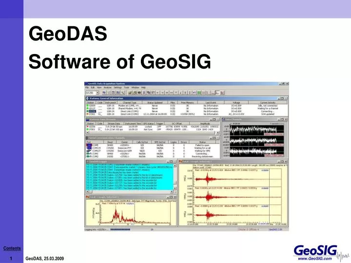
GeoDAS • Software of GeoSIG
Contents • Introduction • Major Features • General Tasks of GeoDAS • Data Analysis • Strong Motion Data Processing • Messenger of GeoDAS • Network Links of GeoDAS • Statistics of Communications • Network Monitor • Event Checks • Station Map • Support for ADC Boards • Static Measurements • Automatic Event Processing • Automatic File Conversion • Thank you
Introduction GeoDAS, Software of GeoSIG
Major Features • GeoDAS, Software of GeoSIG • One of the best rated software of its kind in the industry • Microsoft Windows-based application running under Windows9x / 2000 / NT4 / XP / Vista • Used for:Instrument ConfigurationData AcquisitionData Analysis • Data is delivered through serial communication channels via:Serial PortEthernet (LAN, Internet, Wireless, etc)Modem (Landline, GSM, Satellite, etc) • Can serve several instruments at the same time
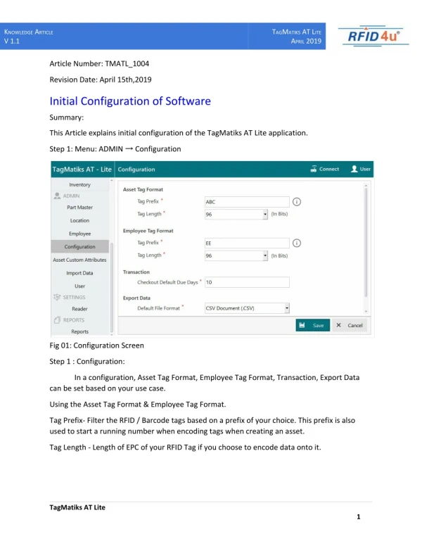
General Tasks of GeoDAS • Setup of an instrument. One can change any parameters of an instrument with GeoDAS. • State of health (SOH) monitoring. GeoDAS performs permanent or periodical monitoring of an instrument status. • Downloading of the event files from an instrument working as a recorder • Off-line event data view and simple data analysis • Support for serial data streams (GSBU GeoSIG-Bergen and CWB or IASPEI formats) • Logger features. GeoDAS keeps important messages in a log file. • Real-time data viewer for an instrument, which provides serial data stream.
Data Analysis • Strong motion, earthquake engineering and civil engineering data analysis and preliminary seismic analysis of recorded data. • Lowpass filtering (e.g. keep signal less than 20 Hz) • Highpass filtering (e.g. keep signals more than 0.2 Hz) • Baseline correction • Integration of the signal to get acceleration velocity displacement • Differentiation of the signal to get displacement velocity acceleration • Vector Sum (of all channels) • Cumulative Absolute Velocity (CAV) • Time domain filtering (Parzen, Hanning, Welch, Hamming) • Effective Values (DIN 45 669) • Damping and Eigenfrequency • Power Spectrum Calculation • Fast Fourier Transformation (FFT) • Terzband Spectrum calculation • Response Spectrum for any damping in acceleration, velocity and displacement • JMA Intensity • STA/LTA Ratio • Manual Event Check • Signal Characteristics • Running a batch of a sequence of above operations
Strong Motion Data Processing PGA peak ground acceleration PGV peak ground velocity SD peak spectral displacements of the measured earthquake shaking. Shakemap
Messenger of GeoDAS • Deliver different types of information from GeoDAS to the subscribers. • Two ways of delivery are currently supported: • email • SMS (short message service).
Network Links of GeoDAS GeoDAS can communicate to other instances of GeoDAS as well as to other applications developed by GeoSIG • This features allows GeoDAS to: • Accept the requests from remote GeoDAS and/or from other applications, • Forward the information provided by data streams to the remote applications, • Launch / monitor / restart an external application • Make the following different GeoDAS services available for the remote clients: - Monitoring State of Health (SOH) - Downloading events and ring buffer files - Requests for statistics of communication - Real time data streaming - Remote configuration
Statistics of Communications Statistical information can be used to optimise communication parameters for the purpose of debugging. The acquired information can be viewed, kept in a file and sent to email recipients. • Statistical information acquired consist of: • The unique station name, • Number of successful logins to the instrument, • Total time spent logged in to the instrument, • The number of downloaded files and total size, • The rate of data transfer from the instrument, • Minimum/maximum/mean waiting time for a free communication channel to lock it and get an access to the current station, • Minimum/maximum/mean waiting time for dialling out, • Number of failed attempts to login to the instrument, • Number of event detected (EVT) messages received, • Number of event completed (FIL) messages received, • Number of state of health (SOH) messages received
Network Monitor Control remote GeoSIG applications and provide general information about them to the subscribers by email and/or by SMS messages. • Restart a remote application • Reboot a remote computer • Periodically checks the status • Logged to the status file. • Enhanced information displayed,monitored and logged
Event Checks • Check whether any event • Can be declared as seismic one • Meet the Operating Basis Earthquake (OBE) and Safe Shutdown Earthquake (SSE) criteria
Station Map Map showing the area where the stations are located
Support for ADC Boards • Acquire data directly from an industry standard A/D converter boards • Adjust trigger settings • Adjust parameters for processing of data streams • Also available for remote nodes • For each channel it is possible to define the following parameters: • Whether it provides data to the acquisition system or not, • Channel name, • Connected Sensor and its full scale, • Full Scale or DC gain, • Units, • Drift Compensation
Static Measurements In case of ADC Channels; all or some of these channels can be configured as static channels. Static Channel: rather slowly changing channel, so it can be sampled with a time interval of several seconds, minutes or even hours. A typical example of static data is the air temperature.
Automatic Event Processing Automatic processing of event files recorded within a selected time interval, usually several hours or days. A report is forwarded for printing out at the default system printer. At the same time all processed data are stored together in a directory and can be printed later manually at any time.
Automatic File Conversion Data files are converted to another format and this operation is performed automatically. All important event-related information Peak event amplitude calculated Both collected and calculated data are inserted into the database Data processing and storage is performed channel-wise.
Thank you… • Thank you…