Download
1 / 20
200 likes | 316 Views
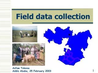
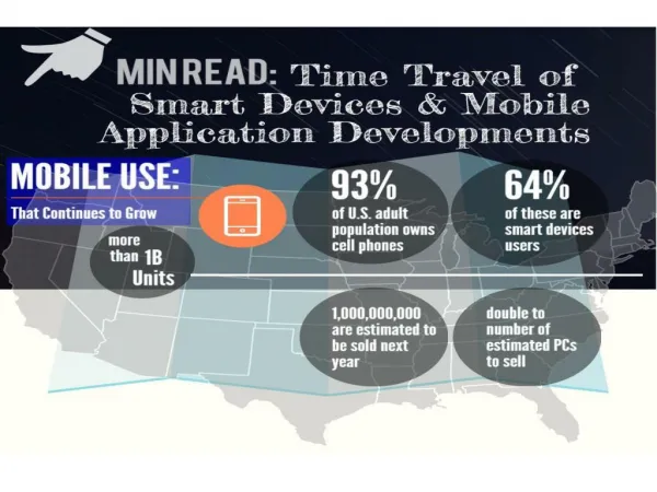
GeoStamping - A field Information collection mobile application. Conference on Geospatial Information technology and Applications. 24 January, 2013 THEME: Mobile Mapping. By: Subrata N. Das, Saurabh Gangwar , Ashok K. Joshi RRSC –Central, Nagpur.

E N D
GeoStamping - A field Information collection mobile application Conference on Geospatial Information technology and Applications 24 January, 2013 THEME: Mobile Mapping By: Subrata N. Das, Saurabh Gangwar , Ashok K. Joshi RRSC –Central, Nagpur
The application has been developed on the Open Source Android mobile platform, allowing it to run on a wide range of devices including modern, high performance smartphones Version Purpose Platform The software has been tested on Android 2 (Froyo/GingerBread ) and Android 4 (IceCreamSandwich) The software can be installed on jellyBeans
The icon which appears on mobile for GeoStamping is: Major Module of the application are: GeoStamp Manager About Exit
Flowchart Acquiring the field data Start Customizing the software Geostamp Start Is Internet connectivity available Y Turnon GPS Data sent to server Manager Getting latitude, longitude ,Accuracy, Altitude N Stop Data send later Load project Acquiring photo and direction of photo Configure the project Asset description Preference manager Encrypting and watermarking Stop Sending Field Data
SIS-DP IWMP GeoSTAMPING: Mobile Field Data Collection Tool CONFIGURING USER INFORMATION ACQUIRING FIELD INFORMATION OF WATERSHED PROJECT LAT/LONG, PHOTO & DESCRIPTION ENCRYPTION & WATERMARKING SENDING DATA TO SERVER & EMAIL GEO-PROCESSING OF DATA FOR GIS VIZUALIZATION & ANALYSIS Main Menu Lat/Long Acquisition Photo Acquisition Description Sending Info. INTEGRATION OF GeoSTAMPED LOCATION WITH BHUVAN / GOOGLE EARTH ALALYZIING TAGS IN SERVER – POINT & DATA WRITING IN SERVER RDBMS (Oracle 11g) AUTO GEO-DATABASE CREATION POINT VISUALIZATION ON BHUVAN & GOOGLE EARTH ASSET MAPPING & ACTIVITY MAPPING LINKING WITH STATE M.I.S. Asset Visualization In Mobile BHUVAN In Mobile Google Earth Online Info on Mobile
Manager menu contains following sub-menu • Customizing the Software using • Load project manager • Config manager • Preference manager
Select the state and download the project list from the server. Saves all the detail information about the User and the project in which he is working in the field.
Acquiring the field Information Getting location via GPS by triangulation. Parameters are Latitude , Longitude and Altitude with best possible accuracy. Satellite parameters acquired via GPS
Choosing Assets – asset category, Asset Type Choosing Descriptions
Textual data is encrypted and stored in mobile device photo is then watermarked and photo data encrypted and ready to be sent to server
Header and footer watermarked providing details of Project Assets/Activities Information
The Field data is ready to be sent to server and/or email The software will check the connectivity and prompt user to send immediately or send later via Send manager
The field data - photo and related textual information is stored in server. The textual information is decrypted, parsed and stored in relational database The server software fetches this data and analyze it according to the project name and generates kml file The kml file is ready to be downloaded by the user while visualizing in mobile device Relational database stores field data The data is decrypted at server Kml file downloaded via Project View Manager
View Project menu contains following sub-menu User can view sent data spatially through IWMP site ,in Bhuvan,Google Earth or on mobile. Downloading kml file
Integration Of GeoStamped Location with :- Mobile GOOGLE EARTH
Installation • The minimum requirement for running the application are:- • Android version 2.2 OS and above • GPS (Global Positioning System) • Orientation sensor • Camera 2Mp • SD Card • Minimum screen resolution of 480X320 • Network Connectivity (2G/3G)
Conclusion: • The software accomplishes field data collection in tamper-proof manner • The data transaction between software on the mobile device and remote • server is online while acquiring field data and sending to server, thereby • eliminating the need of any paper work • This Mobile applications allows for speedy, accurate and transparent • decision making for district/block level planning It is near-real time • experience of data collection Future Scope : • Sending of Multiple photos of the same position on the field at the same time • multi-temporal data collection of the almost same position on the field • Deploying strong security measures while encrypting/decrypting • Facilitating the sending of data via SMS with encryption/decryption using • public/private key cryptosystem
Thank you Email: rrscnagpur@gmail.com Phone: 0712-6621200