Download
1 / 17
290 likes | 1.14k Views
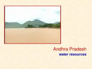
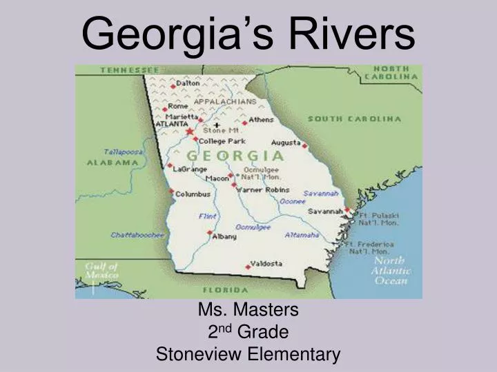
Georgia’s Rivers. Ms. Masters 2 nd Grade Stoneview Elementary. Georgia’s 7 Main Rivers. Altamaha River Chattahooche River Flint River Ocmulgee River Oconee River Savannah River St. Mary’s River. Can you spot them on the map below?. Altamaha River.

E N D
Georgia’s Rivers Ms. Masters 2nd Grade Stoneview Elementary
Georgia’s 7 Main Rivers • Altamaha River • Chattahooche River • Flint River • Ocmulgee River • Oconee River • Savannah River • St. Mary’s River • Can you spot them on the map below?
Altamaha River • The Altamaha River, located in South Georgia, is the largest river in Georgia. • The river was named for a Yamassee Indian chief, Altamaha. • This river is played a large role in Georgia’s history. Many of the large cotton plantations were located along the banks of the river. • Steamboats traveled up and down the river carrying travelers and items to be sold.
Altamaha River Ecosystem • The Altamaha is viewed as the most important ecosystems in the region. This river has many marsh and swamp habitats that make up the Coastal Plain region. • Many different wildlife make their home on this river. Otters, turtles, alligators, and a variety of birds are some of the animals that live on the Altamaha River.
Chattahoochee River • The Chattahoochee River beginsin the Blue Ridge Mountains of Northeast Georgia. • It flows 430 miles through Georgia. The river flows through the capital city of Atlanta. • This river is the main source of water for over half of Georgia’s population. • Eventually, the Chattahooche River joins the Flint River in Southwest Georgia.
What Does Chattahoochee Mean? • Chattahoochee is Creek Indian for “flowered stones”. • The word chatto, which means stone, and the word hooche which means flowered or designs like flowers. • The river was located by Chattahoochee Old Town. The Creek settlement named the river after the settlement.
Flint River • The Flint River begins at Atlanta Hartsfield-Jackson International Airport with the upper portion of the river flowing through the Georgia Piedmont region. • Below the Fall Line( where waterfalls usually begin) the river flows through soft, sandy limestone that make up the Coastal Plain.
Another “Creek” River The Creek Indian name for the river was Thronateeska, which meant flint-picking-up place. Flint is a hard form of rock and was used for making arrowheads or spear points. It was highly valued. The name comes from the Creek word ronoto, which means flint, and hachi, which means stream.
Ocmulgee River The Ocmulgee River is formed in North Central Georgia, just southeast of Atlanta. The Ocmulgee River begins in the Valley and Ridge region and then flows into the Coastal Plain, where it becomes a gentle river. The gentle part of the river makes it a popular place to go canoeing. It is also used for fishing. The Flint is known especially for catfish and bass.
Bubbling Water • Sections of the Ocmulgee River can create rapids, or fast flowing water. It was because of this, the river got it’s name. • Ocmulgee comes from the Creek word that means boiling or bubbling water. It is the combination of “oki”, which means water, and “mulgis”, which means bubbling or boiling.
Oconee River • The Oconee River begins in Hall County in Northeast Georgia. Georgia. • The Oconee River travels south and joins the Ocmulgee River. • Together, both rivers form the Altamaha River, which is the largest river in Georgia.
Oconee River Wildlife • The Oconee River is home to a number of state-protected species such as the Robust Redhorse and many others. • If a species is state-protected that means that it can’t be hunted, caught, trapped, or harmed in any way. The fish above is a Robust Redhorse. This fish was said to be extinct for more than 100 years. Scientists rediscovered this fish in the Oconee River. Click here for a peek at a live video of a Robust Redhorse Sucker
Savannah River • The Savannah River begins as a stream in the Blue Ridge Mountains. • The Savannah River forms most of the border between the states of South Carolina and Georgia. It is around 301 miles long. The river eventually flows into the Atlantic Ocean. • Two major cities are located along the river, Savannah, Georgia, and Augusta, Georgia. They were the central part of English Settlements in early Georgia history. • In 1733, James Oglethorpe built the first Georgia settlement in Savannah.
Savannah means “River of the Shawnees,” named after the remaining part of the Shawnee Indian tribe that lived on the river in early Colonial days. • The Savannah River is now one of Georgia’s largest and longest waterways. Check out the view of the Savannah River from a Tybee Island bridge!
St. Marys River • St. Marys River is named after a Spanish mission, Santa Maria de Guadeloupe, located near the river. • The river was home to early Spanish settlers and it has been said that it was the location for some pirate activity. • The Indian name for the river is Thalthlothaguphka, which means rotten fish.
St. Marys River begins as a tiny stream in the Okefenokee Swamp and forms part of the border between Georgia and Florida. It empties into the Atlantic Ocean. • The river is used mainly for recreation and sightseeing purposes. Camping, canoeing, fishing, and boating are a few of the ways that the river is used for recreation. • More that 65 different species of fish have been identified in the river. Sailing on St. Marys
Resources • Slide 2- usgs.gov • Slide 3- Image by Pfly (Own work) [CC-BY-SA-2.5 http://creativecommons.org/licenses/by-sa/2.5, via Wikimedia Commons • Slide 4- Both Images by mfairlady http://www.flickr.com/photos/mfairlady/ via Wikimedia Commons • Slide 5- Image by Capt Kodak http://www.flickr.com/photos/captkodak/via Wikimedia Commons • Slide 6- Image by jennylizhttp://www.flickr.com/photos/jennyliz/ via Wikimedia Commons • Slide 7 & 8- Both Images by j.s. clarkhttp://www.flickr.com/photos/jsclark/ via Wikimedia Commons • Slide 9- Image by Mark Strozierhttp://www.flickr.com/photos/r80o/ via Wikimedia Commons • Slide 10- Image by Possum1500 http://www.flickr.com/photos/possum1500/ via Wikimedia Commons • Slide 11- Image by Ezra S F http://www.flickr.com/photos/sneezypb/ via Wikimedia Commons • Slide 12- Left image by brian.gratwickehttp://www.flickr.com/photos/briangratwicke/ via Wikimedia Commons, right Image by drivebybiscuits1 http://www.flickr.com/photos/drivebybiscuits1/ via Wikimedia Commons, video by hoyasmeghttp://www.flickr.com/photos/emeryjl/ via Wikimedia Commons • Slide 13- Image by Ken Lund http://www.flickr.com/photos/kenlund/ via Wikimedia Commons • Slide 14- Image by Bruce Tutenhttp://www.flickr.com/photos/savannahgrandfather/ via Wikimedia Commons • Slide 15- Image by db rolenrockhttp://www.flickr.com/photos/rolenrock/ via Wikimedia Commons • Slide 16- Image by jmd41280 http://www.flickr.com/photos/jmd41280/ via Wikimedia Commons