Download
1 / 11
120 likes | 272 Views
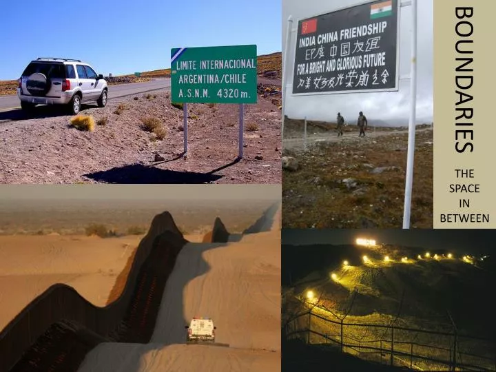
BOUNDARIES. THE SPACE IN BETWEEN. BOUNDARIES. BOUNDARY : an invisible line marking the extent of a state’s territory. Think of it as a vertical plane, extending both into the air and deep into the earth

E N D
BOUNDARIES THE SPACE IN BETWEEN
BOUNDARIES BOUNDARY: an invisible line marking the extent of a state’s territory. Think of it as a vertical plane, extending both into the air and deep into the earth Boundaries control both the shape of a state and the amount of contact a state has with bordering countries. A state’s shape is a centripetal force in generating its national identity. A state’s shape also has major impacts on the ease or difficulty of internal administration. There are five basic state shapes.
STATE SHAPES COMPACT ELONGATED PRORUPTED PERFORATED FRAGMENTED Distance from the center to any boundary does not vary significantly. Compactness is an advantage for small states because communications to all regions are easy to establish if the capital is located in the center. The shape does not, however, ensure peace. Ex: Kenya, Kosovo, Rwanda, Uruguay Long, narrow shape. Internal communications are difficult. Capital is usually placed at the center, and extreme end regions have difficulty communicating with it. EX: Myanmar, Chile, Argentina, Malawi, etc. Otherwise compact but with a large projection Proruptions either: 1) Give access to resource Ex: DRC 2) Separate states ex: Namibia, Afghanistan Completely surrounds another state Ex: South Africa, Senegal An ENCLAVE is a territory or state that falls entirely within another state. Ex: Vatican City, Monaco, Cabinda, Lesotho Has several discontinuous pieces of territory Two Kinds: 1) Fragmented by water Ex: Tanzania, Indonesia 2) Fragmented by an intervening state Ex: Angola, Russia, India, An EXCLAVE is territory legally attached to a state with which it is not contiguous Ex: Cabinda, Alaska
STATE SHAPES …and then there’s one last: LANDLOCKED STATES Landlocked states have no direct outlet to the sea because they are surrounded by other countries. Africa has en especially high number as a result of the colonial era. Landlocked states have an especially difficult time developing international trade because they lack seaports. Ex: Zambia, Malawi, Zimbabwe, Rwanda, Burundi, Uganda, etc.
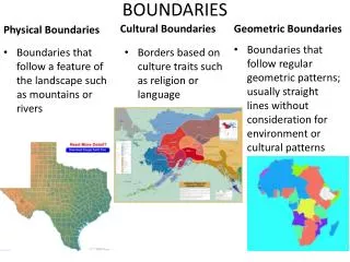
BOUNDARY TYPES Boundaries can cause conflict, especially if their location is not agreed upon by all states that share it. Because a boundaries are where states come in to direct contact, they are often focal points for conflict. There are two main types of boundaries: PHYSICAL BOUNDARIES CULTURAL BOUNDARIES Deserts can be effective boundaries because they are sparsely settled and hard to cross. Ex: The Sahara in N. Africa Mountains can be effective if they are difficult to cross. They are also sparsely settled and permanent. Ex: The Andes between Argentina and Chile Rivers, lakes and oceans can be effective boundaries. They are good because they offer good protection. They can be not so good when they change locations. Determining a sea boundary can be particularly difficult.
LAW OF THE SEA Before 1953, sea boundaries were determined by each state. Then, to ward off the inevitable disputes, the matter was given to the UN to set a standard. UNCLOS (the United Nations Conference on the Law of the Sea) has set international standards for sea boundaries. TERRITORIAL SEA: extends 12 nautical miles off shore. All sovereign rights apply and foreign nationals must have permission to sail them. CONTIGUOUS ZONE: extends 12 nautical miles past the territorial sea. States may apply their own customs to this area. EEZ: the Exclusive Economic Zone extends 200 nautical miles off shore. All ships have right of passage, but state has rights to exploit resources, sell rights, harvest, conserve, manage fisheries and control pollution/piracy/smuggling. HIGH SEAS: area beyond the EEZ, not owned or controlled by any state. Countries less than 400 nautical miles apart must negotiate the location of their respective EEZs.
BOUNDARY TYPES Boundaries can cause conflict, especially if their location is not agreed upon by all states that share it. Because a boundaries are where states come in to direct contact, they are often focal points for conflict. There are two main types of boundaries: PHYSICAL BOUNDARIES CULTURAL BOUNDARIES Deserts can be effective boundaries because they are sparsely settled and hard to cross. Ex: The Sahara in N. Africa Geometric boundaries are straight lines (or arcs following Lat or Long lines) drawn on a map Ex: US/Canada (49°), Libya/Chad Mountains can be effective if they are difficult to cross. They are also sparsely settled and permanent. Ex: The Andes between Argentina and Chile A religious boundary is a type of ethnic boundary separating two states based on religious boundaries Ex: India/Pakistan/Bangladesh Rivers, lakes and oceans can be effective boundaries. They are good because they offer good protection. They can be not so good when they change locations. Determining a sea boundary can be particularly difficult. A language boundary is another type of ethnic boundary where a state’s boundary is drawn to include speakers of that language. Ex: Spain, France, The Versailles Conference
CYPRUS Cyprus is divided between Greeks (78%) in the south and Turks (18%) in the north. When Cyprus gained independence from Britain in 1960, Turks were guaranteed a full share in society and a certain level of autonomy. In 1974, Greek nationalists seized control of the government and Turkey invaded to protect Turkish Cypriots. When the leaders of the coup were removed, the Turkish army stayed and declared independence in 1983 (not recognized by the UN). A wall and a buffer zone was constructed between the two areas (Turkish Cypriots control the northern 36% of the island), and the buffer was patrolled by the UN. More recently, relations between the two have warmed, a portion of the wall was removed, and the UN initiated Cyprus as a member state in 2004.
INTERNAL BOUNDARIES States often draw internal boundaries called CIVIL DIVISIONS to create local government bodies for multiple purposes: To ease administration over large spaces, to separate ethnicities or nationalities, or to advantage a political party. State governments take two basic approaches to running a state: UNITARY STATES FEDERAL STATES Unitary States place most power in the hands of the central government. This approach works best in nation-states with a high degree of internal homogeneity and a strong sense of national unity. Smaller states are more likely to adopt it because it requires a high degree of effective internal communication. Unitary states are especially common in Europe. Some multinational states have adopted unitary systems in an attempt of the majority ethnic group to impose their identity on minority ethnicities. A federal state allocates strong power to units of local government. Local governments possess the power to adopt their own laws. Multinational states may adopt a federal system to empower different nationalities, especially if they are concentrated regionally. The Federal system is also helpful for larger states because the national capital may be too remote to provide effective control Most of the word’s largest states are federal states, however, some smaller states with particularly potent ethnic divisions are also federal (Belgium). At the same time, some large states are unitary (China). In recent years, the global trend has been towards federal governments. Check out France and Poland in the reading.
ELECTORAL GEOGRAPHY Voter districts are redrawn in most democratic countries periodically to ensure that each district has the same number of voters. In theory, the districts are drawn without regards to voting preferences or incumbent politicians. While many countries and some US states use impartial commissions to redraw district lines, many US states leave the redistricting to the state legislature. GERRYMANDERING is when district lines are redrawn so as to favor the incumbent party in the legislature. It has three forms. While gerrymandering is illegal in the US, the supreme court did not dismantle previously gerrymandered districts. WASTED VOTE STACKED VOTE EXCESS VOTE Spreads opposition supporters across districts as a minority in each Links distant areas of like-minded voters through oddly shaped boundaries Concentrates opposition supporters into a few districts CGP Grey’s “Gerrymandering Explained”