Download
1 / 20
200 likes | 358 Views
Geospatial Dimensions For Groundwater Management. A detailed approach to Geospatial Applications for comprehensive management of Groundwater. BY. Sangeeta Deogawanka Independent Journalist, Conservationist Business & Social Consultant.

E N D
Geospatial Dimensions For Groundwater Management A detailed approach to Geospatial Applications for comprehensive management of Groundwater BY Sangeeta Deogawanka Independent Journalist, Conservationist Business & Social Consultant
As natural resources diminish, focus shifts to Groundwater, the primary water resource • Conservation • Judicious / optimal use • Identification of potential aquifers • Devising of drought contingency plans • Undertaking of integrated GW Mgt. in tandem with other deptts., Municipalities, Regional HQs., etc.
APPROACH TO GROUNDWATER Undergoing a paradigm shift from Quantitative Qualitative Broad-based aquifer Localised thematic information mapping [modelled towards native problem resolution & vulnerability assessment] Traditional mindset / tools Cross - platform dimension [integrating hybrid cloud, community, social media, GIS platform, computing, statistical probability models]
Primary Reasons: Understand usage trends Analyse patterns of GW. data Tap good aquifers Ensure lasting supplies for real time GW analysis / on – site decision making Secondary Reasons: Analyse the spatial, temporal & vectoral aspects of GW. data Apply the same for planning Apply the same for integrated GW .Management Apply for GW. Remedial Management Why Map Groundwater?
A COMPLETE STEP-WISE APPROACH TO GEOSPATIAL APPLICATIONS FOR GROUNDWATER MANAGEMENT MASTER TABLE
GROUNDWATER DATA MONITORING GROUNDWATER DATA MODELLING GEOSPATIAL APPLICATION forGROUNDWATER MANAGEMENT
GW Parameters – ground to water level, salinity, temperature, GW chemistry, drawdown Locational Data – Surface discharge, topography, geologic data, no. of tubewells
GW DATA MONITORING THE GEOSPATIAL APPROACH
APPLICATION OF GPS DATA LOGGERS& AQUAMETERS GPS DATA LOGGERS Cost effective & reliable Used for measurement of water levels, temperature, conductivity Applications urban water supplies, salt water intrusion, brine storage thermal profiling, contaminant monitoring APPLICATION OF GPS AQUAMETERS Allow simultaneous measurement of 40 parameters, accurate GPS data, allow overlay with map reading & satellite imagery Applications Contaminant monitoring, Engg. Services, GW analysis
APPLICATION OF PARTICIPATORY GIS Using Community, Public (PPGIS) Social media, Crowdsourcing Applications / Examples Arghyam initiative in Kerala for GW levels mapping New Delhi municipality usage of Facebook for contaminant monitoring Arsenic monitoring in Bangladesh using PPGIS
APPLICATION OF GEOPHYSICAL TECHNIQUES Provide hi resolution information over large aquifers Time & labour saving technique Applications Saltwater intrusions, submarine GW discharge Artificial recharge, aquifer storage & recovery USESurface, Boreholeand Airborne methods in GW studies Borehole Logging – subtle GW flow conditions Ground Penetrating Radar (GPR) – a broadband impulse radar system with high soil penetrating capacity USED for hydrological modelling, measure moisture content of soils, water table maps, define geometry of aquifers, BEST application is in electrically resistive mediums of dry, porous, sandy soils, & where numerous subsystems of GW flow
APPLICATION OF REMOTE SENSING (RS) Provide Imagery & satellite data – with high spatial, spectral, radiometric resolution Applications High resolution requirements, mapping large terrains, For multi-temporal analysis for spatially distributed data For analysis in multi-thematic data format / raster GW data models Microwave Remote Sensing (MRS) An advanced RS technique to map spatial domain of surface soil moisture With temporal dynamics Applications GW Recharge & hydrological studies
GW DATA MAPPING Synchronisation of basic Groundwater Data, using established mapping methods for presentations & analysis GW DATA MODELLING Advanced application of Groundwater Data for Statistical & GIS Modelling in a cross-platform interface / in multiple layers WHAT IS GROUNDWATER DATA APPLICATION
GROUNDWATER MAPPING METHODS • HydrogeologicComplex & Setting Methods (applied to small & medium scale mapping) • Parametric System (mapping of GW parameters in usable format) • Index & Analogical relations (used to consider properties of overlying layers & contaminants, like transport equations) • Mathematical Equations (flow & transport models that integrate multiple input data) • Statistical Methods (applied for small to medium scale mapping, with 3 tier method of selecting GW influencing factors, mapping spatial distribution & concentration of contaminants, & finally establish a statistical algorithm for mapping GW vulnerability
VISUAL DIAGRAMS & MAPS Organised in visible formats as grids, charts, graphs & geo-referenced maps – to allow cross overlay + computation of data models Thematic, Vector/ Raster, Mash-ups, OR continuous data set of raster maps GW maps well location maps plotted in GIS platform, Digital Elevation Models for spatial pattern analysis, land use maps, piezometric level maps, Raterised GW elevation maps (map seasonal & long term trends) DESK TOP & CUSTOMISED SOFTWARE Ready to use Customised Software that allow that allow multi-layered cross platform mapping for study & problem resouluion (Arc GIS Desktop/ SURFER) Data Visulaization Software Allow interactive animation & graphical designs Application – high impact reports GW Monitoring Software (Driver Office, Driver Pocket) Support managing of data loggers Applications – Public Water Agencies & Consultants GROUNDWATER MAPPING PRESENTATION
GEOSPATIAL APPLICATIONS IN GROUNDWATER DATA MODELLING • GEOSTATISTICAL MODELLING applies GW Data for diverse appications Space-time intelligence software – to map arsenic variability Parameter Estimation & Statistical Software – model risk analysis, natural resource management • CONCEPTUAL MODELLING Applications like Hydro GeoAnalyst & Hydro GeoBuidler are applied for GW Data Management; Hydro GeoBuilder works well with FEFLOW & MODFLOW models Data Contouring & Modeling Software – SURFER, GRAPHER, GW CONTOUR, ARCHYDRO GROUNDWATER are applied to first level GW analytics • ADVANCED GW DATA MODELLING Work as both simple contouring / finite difference flow & transport models. Natural Attenuation & Remediation Optimization Models (Hydro GeoAnalyst) support removal of GW contaminants; Unsaturated Zone Models are applied to projects; Borehole Geology Logging Models (LogPlot7) applied in geophysical env.; Pumping & Slug Tests Analysis Software(AquiferTest) for analysis of hydraulic properties of aquifer
GEOSPATIAL APPLICATIONS IN URBAN GROUNDWATER MANAGEMENT • Basic Maps – to understand parameters of city GW • GIS Mapping & modelling Tools – applied to StormWater Management & Flood Controls, design Rainwater Harvesting Systems, Recharge of depleted zones, predict soil subsidence probabilities, devise civic & water engineering solutions through analytic models, urban waste water management, for GW quality assessment, and risk mapping with respect to seepage, contamination INTEGRATED GROUNDWATER MANAGEMENT Applies various mapping, monitoring and modelling methods to work in a cross platform interface that allows for various Departments to wor for a common solution and remediation to GroundWater
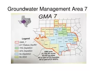
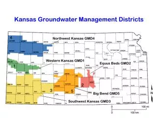
CASE STUDY OF MULBAGAL, KARNATAKA Whereas previous data had suggested an alarming GW depeltion in this area, the application of GIS by ARGHYAM inferred 1. There was no alarming depletion as pumping rate was offset by recharge 2. Portion of recharge was lost to horizontal lateral flow in aquifer topography Various inferences made have helped the Municipality to undertake GW Management decisions for a uniform GW availability
MULBAGAL GW MAPillustrating differences in Groundwater levels