Download
1 / 19
200 likes | 265 Views
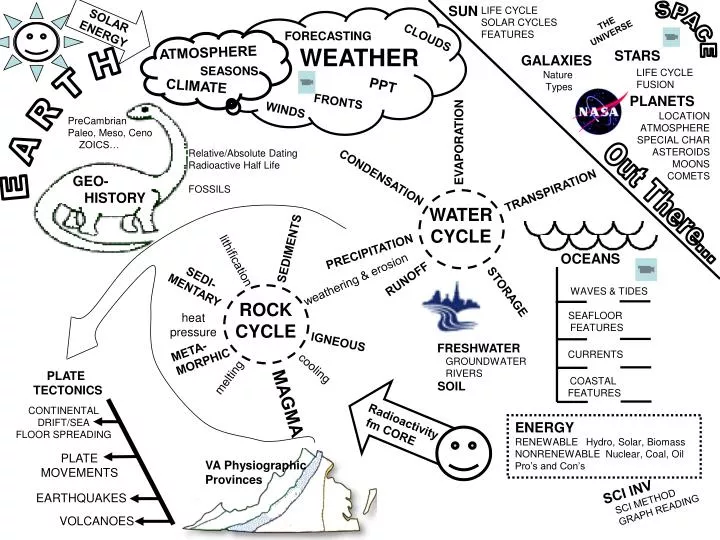
SUN. LIFE CYCLE SOLAR CYCLES FEATURES. THE UNIVERSE. SPACE. STARS. GALAXIES Nature Types. FORECASTING. CLOUDS. WEATHER. ATMOSPHERE. PLANETS. PPT. LOCATION ATMOSPHERE SPECIAL CHAR ASTEROIDS MOONS COMETS. CLIMATE. EVAPORATION. FRONTS. WINDS. WATER

E N D
SUN LIFE CYCLE SOLAR CYCLES FEATURES THE UNIVERSE SPACE STARS GALAXIES Nature Types FORECASTING CLOUDS WEATHER ATMOSPHERE PLANETS PPT LOCATION ATMOSPHERE SPECIAL CHAR ASTEROIDS MOONS COMETS CLIMATE EVAPORATION FRONTS WINDS WATER CYCLE CONDENSATION TRANSPIRATION Out There... PRECIPITATION RUNOFF SOLAR ENERGY STORAGE PLATE TECTONICS OCEANS CONTINENTAL DRIFT/SEA FLOOR SPREADING WAVES & TIDES SEAFLOOR FEATURES PLATE MOVEMENTS CURRENTS EARTHQUAKES COASTAL FEATURES VOLCANOES SEASONS LIFE CYCLE FUSION E A R T H PreCambrian Paleo, Meso, Ceno ZOICS… Relative/Absolute Dating Radioactive Half Life FOSSILS GEO- HISTORY SEDIMENTS lithification SEDI- MENTARY weathering & erosion ROCK CYCLE heat pressure IGNEOUS META- MORPHIC FRESHWATER GROUNDWATER RIVERS cooling melting SOIL MAGMA Radioactivity fm CORE ENERGY RENEWABLE Hydro, Solar, Biomass NONRENEWABLE Nuclear, Coal, Oil Pro’s and Con’s VA Physiographic Provinces SCI INV SCI METHOD GRAPH READING
Solar System Astronomy SUN MERCURY EARTH Sun - The Sun is a star at the center of our Solar System. Powered by FUSION. ~5BY old. Middle aged, average star. TERRESTRIAL (ROCKY) Worlds: Mercury - Mercury is the planet closest to the Sun. Looks like Earth’s moon. Venus - Venus is the second planet from the Sun. It is the hottest planet. Runaway greenhouse due to CO2 (carbon Dioxide) Atmosphere. Earth - Earth is the third planet from the Sun and the planet we live on. ONLY world with LIFE. Mars - Mars is a red planet and the fourth planet from the Sun. Very thin atmosphere. Being probed for possible manned landings this century. JUPITER SATURN MARS PLUTO MARS The GAS GIANTS: Jupiter - Jupiter is the fifth planet from the Sun. This gas giant is the largest planet. Most moons. Studied by GALILEO probe in ’90’s. Hit by comet Shoemaker-Levy 9 in 1994. Moon Europa is an ice covered ocean. Moon Ganymede bigger than Mercury. Saturn - Saturn is the sixth planet from the Sun. This gas giant has large rings. Currently being studied by CASSINI probe. Moon TITAN only moon with an atmosphere (nitrogen like earth – but very cold). Uranus - Uranus is a gas giant and is the seventh planet from the Sun. Orbits with axis tilted 90 degrees. Neptune - Neptune is a gas giant and is usually the eighth planet from the Sun. Fastest winds. Last planet: Pluto - Pluto is a rocky planet that is usually the farthest planet from the Sun. It is the smallest planet. May be a comet.. Odds ‘n Ends Asteroid belt – loose rocks between Mars and Jupiter about the mass of a moon. Comets– dirty snowballs that occasionally come near the sun. Tails form in close and are pushed away by solar wind. Kuiper Belt – cloud of comets just beyond Neptune. Oort Cloud – outer limit of solar system (made up of comets)… URANUS NEPTUNE VENUS
Stellar Life Cycle Astronomy BRITE Red Giant • ALL STARS: • Start in a NEBULA (remains of an exploded star) • GRAVITY pulls material together • Once large enough, FUSION begins – turns hydrogen to helium -- the star is born • Enters MAIN SEQUENCE • Big/hot stars have short lives (Blue/Red Giants) • medium/cooler stars live longer (Sun is an average star –will live about 10 BY) • smallest stars (Red Dwarves) live longest • Small stars will eventually just burn out-a brown dwarf • Medium Stars: Once hydrogen all burned up star will EXPAND to a red giant (destroying any planets present…) and start FUSION of Helium. • Eventually blow off excess gasses to create a planetary nebula. The star itself will shrink to a WHITE DWARF • Large Stars: Expand to Red Supergiants. • Large mass (5-10 suns) explode as SUPERNOVA and collapse into NEUTRON STARS. • Very large mass (10++ suns) explode as SUPERNOVA and collapse into BLACk HOLES Main Sequence NEBULA FUSION White Dwarf DIM TEMP Hertzsprung Russel (HR)Diagram GALAXIES: Billions of stars orbiting a central point (usually a black hole). Stars are in random clumps. 3 types: Spiral Galaxies (Like ours – the Milky Way) Elliptical Galaxies – ‘ball of stars’ Irregular Galaxies – loose clumps. UNIVERSE: Started about 12-15 BY ago in the BIG BANG. Expanding ever since. Galaxies arranged in irregular clumps. GRAVITY DRIVES EVERYTHING!
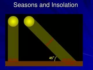
LOWER INTENSITY SOLAR ENERGY. Some slant at surface. MOST INTENSE or CONCENTRATED SOLAR ENERGY. Not slanted. LEAST INTENSE or CONCENTRATED SOLAR ENERGY. Maximum slant. Angle sunlight strikes the earth determines the amount of heat received per square foot. Called angle of incidence. The lower the angle, the less ‘warmth’ will be felt on the surface. Isobars - Lines of EQUAL pressure Closer together = stronger winds WEAKER WINDS STRONGER WINDS
Types of Lifting - clouds form by LIFTING of moist air in cooler, lower pressure air - causing clouds to form when the temperature reaches DEWPOINT OROGRAPHIC - prevailing winds are lifted by mountain ranges. Rains on UPWIND side, very dry on downwind side (rain shadow effect). Californias Sierra nevada mountains. This is why Nevada is a desert. CONVERGENCE - Low pressure area draws air in and up. CONVECTION - Warm Air rising - how thunderstorms are formed.. FRONTAL - Cold or Warm fronts cause warm air to rise over cooler air - creating clouds, Types of Precipitation FREEZING RAIN - FREEZES ON CONTACT SLEET - FREEZES IN AIR SNOW RAIN Weather Fronts Occluded front
Rising Steady Falling Cloud Cover Pressure Rules: memorize how to calculate... 1) Last digit always the decimal 2) if 1st digit <=5 then put 10 in front EX: 138 = 1013.8 mb 3) if 1st digit > 5 then put 9 in front EX: 699 = 969.9 mb Smoke Haze Dust Blowing Snow Lightning Funnel Cloud Light Fog Heavy Fog Rain Shower Snow Shower Thunderstorm Freezing Drizzle Freezing Rain Sleet Reading Weather Station Models - (F) current weather symbols (don’t need to memorize these…) (F) Weather map front symbols - memorize…. W I N D S be able to calculate WARM FRONT COLD FRONT STATIONARY FRONT OCCLUDED FRONT
Calculating Relative Humidity 1) You must use a psychrometer to calculate the Wet bulb and Dry bulb temperatures. 2) The DRY BULB TEMPERATURE will be listed down the left side of the table. If it falls between two listed numbers, then interpolate (estimate).: EX: Dry Bulb is 11 degrees - then the Dry-Wet Humidities will be: 88.5, 77, 66, 55.5, 45.5, and so on… 3) SUBTRACT the WET BULB TEMPERATURE from the DRY BULB TEMPERATURE. The result will be found along the top row of the table. 4) Now take the DRY BULB TEMP and DIFFERENCE TEMP - where the row and column cross, that will be the Percent Relative Humidity. 5) EXAMPLE: Dry Bulb Temp = Td = 30º C Wet Bulb Temp = Tw = 25º C Td - Tw = 5º C Relative Humidity = 67% 6) Given any TWO elements, you can easily calculate the third element. Td = 28º C RH = 85% Tw = ? >>> Td - Tw = 2º C so Tw = 26º C
HEIGHT Motion pattern in deep water SHALLOW WATER WAVE Wave still deepwater to here THE MOON has the greatest effect on tides. This is because the moon is so much closer than the sun to the Earth. The height of the high tides is related to the phases of the moon as shown here. QTR MOON Tide Model Lowest FULL MOON NEW MOON 2nd highest highest Deep water waves are not moving water, only energy. Once a wave reaches shallow water and starts to ‘feel’ the bottom (at 1/2 its wavelength does it begin to move water. Surfers sit on their boards in deeper water and just bob up and down, in order to ride a wave they have to paddle into shallow water. Deep water and shallow water depend on the wave length. Waves Lowest QTR MOON
Ocean Currents Currents are driven by the prevailing winds and the positions of the continents. Currents carry heat away from the equator towards the poles. Warm currents tend to make the winters less severe along the shorelines they pass near. Cold currents tend to make the summers cooler along the shorelines they pass near.. In general, a city on a seacoast will be cooler in summer and warmer in the winter than another city at the same LATITUDE, but located farther inland. WARM Currents flow AWAY from the equator . COLD Currents flow TOWARDS the equator. The Gulf Stream is the principle current affecting the East Coast of the United States and Northern Europe.
I G 0 m 5000m 10000m I H SEA FLOOR FEATURES • A) continental Shelf - extension of coastal land into the ocean. US East coast has very wide shelf. Still part of continent, so underlain with granite. • B) continental Slope - true edge of continent - granite basement rock ends and basaltic ocean rock begins. Very steep dropoff. • C) Continental Rise - debris broken off from continental shelf/slope and dropped on deep ocean floor. • D) Abyssal Plains - wide, flat, featureless deep ocean areas covered with deep sediment deposits. The TITANIC lies on one of these. • E) Seamounts - Underwater mountains. Volcanic in origin steeper than on land since water is denser that air, rock piles can be steeper. A seamount that breaks the surface is called an island. ATLANTIC OCEAN BASIN • F) Mid Ocean Ridge -Starting point of Tectonic Plates. The centerline of the ridge is volcanically active and is the source of seafloor material that continues to widen the Atlantic Ocean. The Ridge has many Transform faults along it to relieve the strain of the uneven spreading. These transform faults give the mid ocean ridge system (the longest mountain range on earth - over 46,000 miles!) it ‘baseball seam’ appearance. PACIFIC OCEAN BASIN • G) Mid Pacific Rise - not exactly mid anything! More along the eastern edge. Same as the Mid Atlantic Ridge (connected - so part of same ‘mountain range’. • H) seamounts/guyots - Underwater mountains. Guyots are seamounts that once were islands, but have been eroded and subsided (sunk) beneath the ocean. There are some in the Atlantic, but since the Pacific is much older, there are lots more. (see island evolution below). • I) Trenches - deepest points in the ocean. (Marianas Trench - Western Pacific is ~12,000 meters deep). Mark end of Plate Boundaries - SUBDUCTION ZONES. The western Pacific Trench (shown above) is where the Pacific Plate dives under the Asian Plate. On the Eastern edge (California coast) there is another (smaller) trench. This trench is partially blocked by the part of California moving north and is why there are so many earthquakes there.
A igneous Forms from molten material - intrusive or extrusive B sediments Fragments of all types of rock. Cemented together Fragments of all types of rock. C sedimentary Rock that has been softened and changed by heat and pressure but NOT MELTED. D metamorphic
condensation precipitation transpiration evaporation runoff groundwater Groundwater Diagram Saturated - full of water Permeable - water can pass through or stay inside it. Impermeable - waterproof. Water cannot pass through it.Impervious Cone of depression is a dry zone that forms when water is drawn from a well. Hydrologic or Water Cycle Diagram
Karst Topography Ridge and Valley Province of VA Caves, sinkholes, disappearing streams. Area made of limestone. Acids in rain and soil cause rock to chemically weather and form caves. Stream Development MATURE - curves (meanders), slower flow. wide valleys, narrow flood plains. 50/50 EROSIONAL & DEPOSITIONAL OLD - large meanders, slowest flowing. wide valleys & flood plains. Oxbow lakes MOSTLY DEPOSITIONAL YOUTH - straight, fast flow. Rapids, V shaped valleys, waterfalls. MOSTLY EROSIONAL Porosity and Permeability - the ability of water to pass through a solid substance Porous material is needed to create aquifers to store water. Materials that prevent water from passing through are called non-porous or impermeable.
Types of Plate Boundaries Convergent - colliding - Oceanic to Continent (Pacific Northwest- Cascades) Oceanic to Oceanic (Japan) Trenches and Subduction Zones Transform - sliding past each other - any combination possible (San Andreas Fault in Calif) Convergent - colliding - Continent to Continent (India & Asia at Himalayas) Divergent - pulling apart - mid ocean ridges (26,000 miles along ocean floor) Inside the Earth S Wave Shadow Zone - since the earthquake secondary waves cannot travel though liquids -this was the first proof outer core was liquid...
Ocean-Ocean Convergence Ocean-Continent Convergence Mid Ocean Divergence Cont-Cont Convergence
Earthquakes and Faulting HANGING WALL FOOT WALL A B C D Terms associated with Earthquakes: A. Surface fault line B. Epicenter C. Focus A-C-D Plane the movement fault Earthquake energy waves: A. Surface wave - most destructive. Slowest wave. Radiates from the epicenter. Combination of side to side and up and down motion. B. Shear wave (S Wave) - 2nd fastest. Only travels through solids. C. Pressure Wave (P Wave) - Fastest wave. Travels through solids, liquids, and gasses. D. Normal or non-earthquake state. A. UNFAULTED landscape -no cracks no movement, no pressures. B. A NORMAL FAULT - land under TENSION (being pulled apart) block slides down the footwall the ‘normal’ thing to do is slide down… C. A STRIKE SLIP FAULT - land under SHEAR STRESS (pulled horizontally in opposite directions) associated with TRANSFORM BOUNDARIES California’s San Andreas Fault is a classic example D. A REVERSE FAULT - land under COMPRESSION (being squeezed) block pushed up the footwall
melting cooling Virginia rock and mineral resources including but not limited to coal, gravel, limestone, and titanium. Crushed stone is Virginia biggest mineral resource. The Chesapeake Bay Estuary is a resource with high biological activity and economic returns. It is the largest estuary in the world and in one of the most densely populated areas of the world. It is in great danger. SEDIMENTARY The Appalachians are the oldest mountain range in North America, they are FOLDED MOUNTAINS, formed when Africa and North America Collided about 250 MYA. * The Rock Cycle in Virginia * * Coastal Plains- Compacted Sediments, too young for rocks Ridge & Valley – Folded Layers. Karst (Caves) Appalachian Plateau – Flat eroded layers weathering & erosion Heat & pressure Sediments are everywhere- Rivers carry them to the ATLANTIC METAMORPHIC IGNEOUS * * Piedmont- Gneiss, the ‘roots’ of the original Appalachians. Blue Ridge – Some Basalt MagmA NO VOLCANOES!
Virginia’s Physiographic Provinces The five physiographic provinces of Virginia are Coastal Plain, Piedmont, Blue Ridge, Valley and Ridge, and Appalachian Plateau. • The Coastal Plain is a flat area underlain by young, unconsolidated sediments. These layers of sediment were produced by erosion of the Appalachian Mountains and then deposited on the Coastal Plain. • The Piedmont is an area of rolling hills underlain by mostly ancient igneous and metamorphic rocks. The igneous rocks are the roots of volcanoes formed during an ancient episode of subduction that occurred before the formation of the Appalachian Mountains. • The Blue Ridge is a high ridge separating the Piedmont from the Valley and Ridge Province. The billion-year-old igneous and metamorphic rocks of the Blue Ridge are the oldest in the state. Some metamorphism of these rocks occurred during the formation of the Appalachian Mountains. • The Valley and Ridge province is an area with long parallel ridges and valleys underlain by ancient folded and faulted sedimentary rocks. The folding and faulting of the sedimentary rocks occurred during a collision between Africa and North America. The collision, which occurred in the late Paleozoic era, produced the Appalachian Mountains. • The Appalachian Plateau has rugged, irregular topography and is underlain by ancient, flat-lying sedimentary rocks. The area is actually a series of plateaus separated by faults. Most of Virginia.s coal resources are found in the plateau province.