Download
1 / 16
160 likes | 233 Views
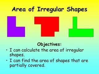
Boundary Disputes & State Shapes . Elongated State : state that is geographically long and narrow, ie . Chile. . State Shapes . Compact State : the distance from the geographic center of the area to any point on the boundary does not vary greatly, ie . Hungary.

E N D
Elongated State: state that is geographically long and narrow, ie. Chile. State Shapes
Compact State: the distance from the geographic center of the area to any point on the boundary does not vary greatly, ie. Hungary.
Fragmented State: state split into many pieces, ie. Philippines and Indonesia.
Landlocked State: state not having direct access to an ocean, ie. Bolivia.
Perforated State: state that totally surrounds another state, ie. South Africa.
Prorupt State: state having a portion of territory that is elongated, ie. Thailand
Frontier - zone where no state exercises political control, ie. Antarctica
Borderlines may be finite, but they can become quite irregular in pattern especially where cultural borderlines become fuzzy • Enclave- minority culture group concentrated inside a country that is dominated by a different, larger cultural group • EX: as simple as an ethnic neighborhood or a large area such as Quebec Enclave & Exclave
Exclave- a fragmented piece of sovereign territory separated by land from the main part of the states territory • EX: Exclave is Alaska, its controlling State is the United States and its separated from its controlling state by Canada
Political boundaries represent the spatial limit of the political organization of territory • They exist at different scales: • Supra-national-scale organizations, such as UN • State-scale • Intra-state scale; boundaries used for the many sub-divisions of territory within the state Boundary Scale
May be a source of friction between competing political entities (flashpoints) • May serve as peaceful reminders of contrasting but accepted differences
Centripetal forces • A clearly bounded territory promotes unity/national stability • Centrifugal forces • The more boundaries possessed by a state, the greater is the likelihood of conflict which disrupts unity/national stability Boundaries & state cohesiveness
Possible centrifugal forces: • internal divisions in language, religion • lack of a long history in common • state boundaries that are subject to dispute • Possible centripetal forces: • clear and well accepted state identity • long state history • boundaries that are clearly delimited and well-accepted
Unitary State – centralized power • For example, Cuba, former Soviet Union, • North Korea • Federal State – de-centralized power • For example, U.S., Nigeria, India Remember 2 Types of States