Download
1 / 23
230 likes | 341 Views
The Benefit of Improved GOES Products in the NWS Forecast Offices. Greg Mandt National Weather Service Director of the Office of Climate, Water, and Weather Services May 23, 2001. GOES…the Evolution Continues. GOES Assessment. 1st Tornado 5:55 pm. 2 Tornadoes 6:34-6:55 pm.

E N D
The Benefit of Improved GOES Products in the NWS Forecast Offices Greg Mandt National Weather Service Director of the Office of Climate, Water, and Weather Services May 23, 2001
1st Tornado 5:55 pm 2 Tornadoes 6:34-6:55 pm 9 Tornadoes 7:08-8:47 pm 3 Tornadoes 9:02-10:01 pm
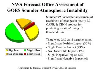
GOES Sounder Assessment MN/IA Tornadoes WFOs credit the GOES Sounder data with helping them focus in on this tornado outbreak. The verification statistics (below) for the event, compared to the national averages and the NWS long-range goals bear this out: Tornadoes MSX/DMX National 2005 Ave (200) Goal** Number 15 -- -- POD 0.73 0.63 0.80 FAR 0.31 0.75 0.40 LT (min) 13.8 9.0 15.0 ** all tornadoes Note: The False Alarm Rate exceeds the 2005 goal while the Probability Of Detection and Lead-Time nearly hit the long-range goal.
Thunderstorm Auto-Nowcast System • Produces 0-2 hr time and place specific forecast • Expert system utilizes fuzzy logic • Ingest multiple data sets • 4-D Variational Doppler Radar Analysis System (VDRAS) • Extrapolates radar echos • Forecast storm initiation, growth and dissipation • Algorithms derive forecast parameters based on the characteristics of the boundary-layer, storms, and clouds.
Boundary-relative steering flow Steering flow likelihood field after weighting Example of Combining Fields to Forecast Thunderstorm Location
Collision likelihood field weighted and overlaid on previous field Example of Combining Fields to Forecast Thunderstorm Location Boundary collision
Radar cumulus likelihood field weighted and overlaid on previous fields Example of Combining Fields to Forecast Thunderstorm Location Radar cumulus
threshold and contoured Example of Combining Fields to Forecast Thunderstorm Location Forecast verification Likelihood fields are summed, produce final forecast
2 June 2000 - Challenge to NWS Forecasters Pre-frontal squall line develops Pre-frontal squall line develops “…Although our forecasters had discussed the potential for severe thunderstorms to break out, we were anticipating a late start based on extrapolation of the line of storms over Pennsylvania. Our office was behind the curve… The 2 June event underscores the critical nature of detecting boundaries to help in the convective initiation problem.” -Steve Zubrick, NWS SOO Cold Front Cold Front
2 June 2000 Convergence boundary is yellow line VDRAS vectors are overlaid 15 min intervals
June 2, 200020:33 – 23:02 UTC Visible Infrared
2 June 2000 30 min Forecasts AN-radar 30 min Forecast AN-radar/satellite 30 min Forecast
2 June 2000 30 min Verification AN-radar 30 min Verification AN-radar/satellite 30 min Verification
Summary of NWS Requirements for GOES-R Plus • Faster Scanning • 5 minute CONUS updates • 15 minute Full Disk update • Improved Resolution of Imagery • 0.5 km Visible • 2 km IR • No Black Outs Due to Eclipse/Keep-out-Zones • Improved Sounder Spatial Coverage