Download
1 / 25
250 likes | 341 Views
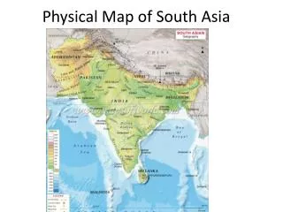
South Asia: The Land- PART 1. Ch. 23 Sec. 1. Separate Land. Mountains form a border from the rest of Asia Making a subcontinent Large, distinct landmass that’s joined to a continent Half the size of continental U.S. Separate Land. 3 bodies of water border the subcontinent:

E N D
South Asia: The Land- PART 1 Ch. 23 Sec. 1
Separate Land • Mountains form a border from the rest of Asia Making a subcontinent • Large, distinct landmass that’s joined to a continent • Half the size of continental U.S.
Separate Land • 3 bodies of water border the subcontinent: • Arabian Sea West • Bay of Bengal East • Indian Ocean South INDIAN OCEAN
Land of Variety • Young, high mountains (in N) & old, eroded mountains (in S) • High deserts & rich, lush valleys (N) • Flat plateaus & terraced foothills (S)
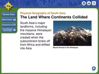
The Himalaya • Formed when the Indian subcontinent collided with Eurasian plate • Indian subcontinent used to be connected to Africa, then broke away • Mt. Everest (highest point on Earth): 29,035 ft. • Still growing! (0.5 cm per yr)
Rich Ganges plain Dry Tibet plateau
Other Northern Mts. • Karakoram Mts. (most N) -K2 • Hindu Kush (NW) • Complete the wall of mts. b/w S. Asia & the rest of Asia • Narrow passes allowed few invaders in (Khyber Pass- b/w Pakistan & Afghanistan) • Protected region from outside influence
Karakoram Hindu Kush HIMALAYA
Highest Concentration of peaks over five miles in height to be found anywhere on Earth! KARAKORAM MTS.
Khyber Pass • Recorded use as far back as Alexander the Great! • Many Afghan wars fought here • Used by NATO forces now, Taliban attempts to blow up passes/bridges
Vindhya Range • Caused by previous convergence of plates not as tall as Himalaya • Divides India into N & S regions (in Central India) • 2 distinct cultures * • Arid to NW • Fertile to NE
Southern Highlands • Eastern and Western Ghats • Eroded mts. (why?) • Triangle of rugged ‘hills’ • E.G. older than W.G. (formed w/ diff. super continents) • W.G. formed really as Deccan Plateau faulted from super continent (150 mil. yrs ago) • W.G. are a biodiversity hotspot!
Eastern Ghats Western Ghats
In WG: about 6,000 plant species and 1,250 animal species47% endemic!
Southern Highlands • Deccan Plateau • Once covered in lava (eruptions occurred millions of yrs ago) now has rich black soil, BUT… • W.G. prevent rain from reaching D.P. very arid
Deccan Traps: volcanic feature eruption/release of gases killed dinos??