Download
1 / 21
230 likes | 246 Views
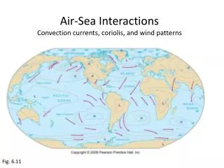
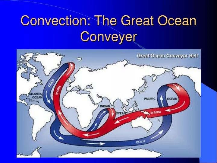
Convection: The Great Ocean Conveyer. Also convection: Upwelling in the World Ocean. Mechanisms that create ocean upwelling. Wind Coriolis Effect. Upwelling refers to deep water that is brought to the surface.

E N D
Mechanisms that create ocean upwelling • Wind • Coriolis Effect
Upwelling refers to deep water that is brought to the surface. Areas of upwelling are created by surface winds that pull water away from an area. This deficit of water on the surface invites water to come up from deeper regions.
Types of Upwelling • Equatorial • Coastal • Seasonal
1. Equatorial Upwelling Water Flow Upwelling
3. Seasonal upwelling Wind Wind Onshore winds pile water up on shore, thus surface water will be forced downward. This is ‘downwelling’. Offshore winds take water away from shore, thus water from depth will upwell to the surface.
The Monsoonal wind shifts in Oman create very different conditions. Wind Wind April, 1999 Onshore winds: Downwelling August, 1999 Offshore winds: Upwelling
Identifying upwelling on satellite-derived maps • Sea Surface Temperature • Ocean Color
The deep water that surfaces in upwelling is cold; by looking at Sea Surface Temperature maps we can identify cool upwelled water versus hotter surface water.
Upwelled water also contains nutrients (nitrate, phosphate, silicate) and dissolved gases (oxygen and carbon dioxide) that are not utilized at depth because of a lack of sunlight.Now on the surface, these nutrients and gases help to fuel photosynthesis by small algae called phytoplankton.
Phytoplankton photosynthesize using specialized color pigments called chlorophyll. Thus, “Ocean Color” maps are another way to identify areas of upwelling. Where on this ocean color map are high phytoplankton concentrations?
Ecological and Economic effects of upwelling: • Upwelling leads to more phytoplankton • More phytoplankton leads to more fish • More fish lead to commercial fishing jobs and to more seafood
Phytoplankton come in many shapes and forms. Collectively they form the base of oceanic food webs. Without upwelling many of the world’s fisheries would not thrive.
Along Peru’s coast, an El Nino event decreases the coastal winds. Thus the upwelling from below is slowed. An El Nino condition results from weakened trade winds in the western Pacific Ocean near Indonesia, allowing piled-up warm water to flow toward South America.
Even though upwelling areas account for only 1% of the ocean surface, they support 50% of the worlds fisheries.
Upwelling and Fisheries January April July October Using this series of Sea Surface Temperature Maps from 1999, can you determine areas/times for possible fisheries? (Hint: Look at Peru’s coast in January and April. Look at the northwestern tip of Africa in July and October.)