Download
1 / 22
220 likes | 306 Views

E N D
Prof. Dr. Viktória SzirmaiConnections between the Characteristics of the Spatial-Social Structure of the Hungarian Metropolitan Regions and the Well-being Levels of Different Social Groups.Head of the European Urban and Regional Studies Department, University Professor, Kodolányi János University of Applied Sciencesviktoria.szirmai@chello.hu „The Power of Geography and the Role of Spatial Information” 15-17 May , 2014 Valetta , Malta EUROGEO Conference Research has been realised within the confines of TÁMOP 4.2.2.A-11/1/KONV-2012-0069 project
Starting points The main aims of this lecture are: • to contribute to the principal mission of this session by certain empirical research results, • and add to the study of the basic scientific question of our session: is there a connection between the European urban development and well-being issues? To realise these objectives it is necessary : • to present the spatial –social structures of the Hungarian Metropolitan areas, and their changes, • to analyse the connections between the characteristics of socio-spatial structures and the well-being levels of the urban population.
Because of the current European (and Hungarian) spatial- social problems (inequalities, urban poverty, exclusion) Because of the lack of empirical knowledge regarding the realisation of the well –being concept. (Stiglitz, J.E. – Sen, A. – Fitoussi, J-P. (2009) Report by the Commission on the Measurement of Economic Performance and Social Progress.) Why is it important to reveal the proposed issues?
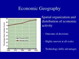
It formulated a new development model, The new model is an important step to manage the social and economic problems . This model is based on the social dimensionsand not on the economic factors, The GDP data are not sufficient to express the social development, New measurement tools are necessary: including the social well-being, social progress and the sustainability. But this model is theoretical and it has no empirical background A comprehensive empirical research project intends to test the relevancy of the concept in the context of the Hungarian urban areas. Material living –standards (income, consumption and wealth), Health, Education, Personal activities including work, Political voice and governance , Social connections and relationships, Environment (present and future conditions), Insecurity, of an economic as well as a physical nature. What are the main statements of the Stiglitz report ? What are the main dimensions of the Stiglitz model?
The lecture is based on two important researches: 1.) "„Urban areas, spatial and social inequalities and conflicts - Spatial and social dimensions of European competitiveness , supported by the Hungarian National Research Project (realisation in 2005) (reference number 5/083/2004) Empirical survey with a sample of 5000 persons, in 9 large cities and outskrit zones. 2) „Social Conflicts – Social Well-being and Security – Competitiveness and Social Development. (realisation in 2014 ) Empirical survey with a sample of 5000 persons, in 9 large cities and outskrit zones. (reference number TÁMOP-4.2.2. A-11/1/KONV -2012-0069.)
The changes of the spatial -social structures of the Hungarian metropolitan regions (between 2005-2014)
1) The previous hierarchical spatial –social structural model changed, 2) It has become more balanced: Due to the gentrification of the cities, Due to the sprawl of the educated strata, Due to the new outflow to the outpart of cities, Due to the renewal of the outpart areas (the new gated communities). New trends:
The spatial distribution of population by educational level in the 9 Hungarian urban regions (%, 2005)
The spatial distribution of population by educational level in the 9 Hungarian urban regions (%, 2014)
The spatialdistribution of populationbythetypeofemploymentinthe 9 Hungarianurbanregions (%, 2005)
The spatialdistribution of populationbythetypeofemploymentinthe 9 Hungarianurbanregions (%, 2014)
The analyses have not been finished yet!! • The aim is to create an aggregate measure form based on the 8 well –being dimensions What can we see already? • There is a certain connection, certain well-being indicators are correlated to the local positions of the urban zones, • in the case of income there are connections in the hierarchical and balanced period also (in 2005 and 2014) There is certain homogenisation in the living standards between the inhabitants who live in the different urban zones • But in the other cases of data the relations are not clear yet. • It is necessary to carry out multi-dimensional analyses.
The spatialdistribution of populationbymonthlyincomeinthe 9 Hungarianurbanregions (%, 2005)
The spatialdistribution of populationbymonthlyincomeinthe 9 Hungarianurbanregions (%, 2014)
The spatialdistribution of populationbyemployment status inthe 9 Hungarianurbanregions (%, 2005)
The spatialdistribution of populationbyemployment status inthe 9 Hungarianurbanregions (%, 2014)
The spatialdistribution of populationbyhealthsatisfactioninthe 9 Hungarianurbanregions (%, 2014)
Finally The principal research questions in the future: • Are there relevant connections between the spatial structures of the Hungarian urban areas and the well-being levels of the analysed population? • What do these connections mean exactly? • What are the main reasons of the connections? • Are the connections mutual ? (when the two different phenomena, the spatial structures and the well –being levels strengthen the effects of each other ) • Or on the contrary : are the two different phenomena functioning independently ?
A párizsi társadalom területi elhelyezkedésének a változásai