Download
1 / 21
210 likes | 330 Views
The Global Positioning System A Worldwide Information Utility. ESTME Week March 2003 Office of Space Commercialization Technology Administration U.S. Department of Commerce. What is GPS?. Constellation of 24+ satellites operated by U.S. Air Force Satellites broadcast precise time information

E N D
The Global Positioning SystemA Worldwide Information Utility ESTME WeekMarch 2003 Office of Space CommercializationTechnology AdministrationU.S. Department of Commerce
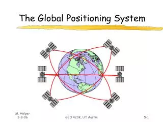
What is GPS? • Constellation of 24+ satellites operated by U.S. Air Force • Satellites broadcast precise time information • Using this information, you can easily calculate your exact location on the Earth • GPS service is available: • Anywhere in the world • 24 hours a day • Under all weather conditions • For FREE!
How It Works RATE = Speed of Light (300,000 km/s) TIME = How long it takes for the signalto reach the receiver RATE x TIME = DISTANCE TIME = 1 second DISTANCE = 300,000 km It’s 9:30:00 Now it’s 9:30:01
How It Works With four or more satellites, a GPS receiver can triangulate your precise position in space and time
GPS is a “Dual-Use” Technology • Originally developed for military purposes • Prominent in Gulf War, Afghanistan (“smart bombs”) • Will be critical to operations in Iraq • Civilian were given access in 1983 • Commercial use now dwarfs military use • GPS is jointly managed at a national level by the Interagency GPS Executive Board (IGEB)
Interagency GPS Executive Board Defense Transportation State Commerce Agriculture Interior NASA Joint Chiefs of Staff Justice
Commercial GPS Applications Span A Wide Range of Economic Activities Satellite Ops: Ephemeris, Timing Power Grid Interfaces Personal Navigation Surveying & Mapping Trucking & Shipping Aviation Communications: Network Timing, Synchronization Recreation Railroads Fishing & Boating Off shore Drilling
Global Sales by Market Segment $ Millions Source: ITA, 1998
New Commercial Applications Are Developed Every Day • Open pit mining • Child safety • Automatic snowplow guidance • Spacecraft control • Power grid management
Huge Potential Exists in the Market for Value Added Services • Software development • Embedded applications • Localized Geographical Information Systems (GIS) • Internet integration • Wireless markets • M-Commerce (Translation: you could make a lot of money developing this stuff!)
Transportation • Greater safety, fewer accidents • More efficient routes, fuel savings • Improved traffic throughput
Surveying & Mapping • Surveying is required before building anything • Buildings • Dams • Power lines • Telecom towers • Pipelines • GPS mapping is especially useful for: • Oil, gas, and mineral exploration • Flood/disaster planning • GPS technology enables <1 cm accuracy and 100%-300% savings in time, cost, & labor
Construction • Machinery, asset, and personnel management • Rapid surveys for laying foundation piles, etc. • Accident prevention • Remote control of machinery possible GPS/RTK technology was used in the construction of the Øresund Bridge between Denmark and Sweden
Scientific Research • Monitoring geological change • Glaciers, tectonic plates, earthquakes, volcanoes • Wildlife behavior • Atmospheric modeling • Water vapor content • Oceanic studies • Tidal patterns • Surface mapping • Time transfer
Environmental Management • Forestry • Wetlands management • Natural resource management • Fisheries boundary enforcement • Endangered species and habitat preservation • Hazardous material cleanup • Oil spills, toxic waste
Timing • GPS offers an inexpensive alternative to costly, high maintenance timing equipment • Telecommunications network synchronization & management • Phones, pagers, wireless systems • LANs, WANs, Internet • Financial transactions • Electrical power grid management & fault location • Digital signatures for e-commerce
Precision Agriculture • Maximize use of resources • Optimized plowing of crop rows • Tailored applications of seeds, fertilizer, water, pesticides • Improved management of land, machinery, personnel, time • Greater crop yields • Net benefit: $5-14 per acre • Minimize environmental impacts • Localized identification and treatment of distressed crops reduces chemical use • Precise leveling of fields prevents fluid runoff
Consumer/Recreational • Portable receivers for fishermen, hunters, hikers, cyclists, etc. • Integration of GPS into cellular phones (E-911), wristwatches, PDA’s • Recreational facilities -- golf courses, ski resorts
Yesterday 25-100 m
Today 6-10 m
Where am I? Plus: Better resistance to interference