Download
1 / 57
600 likes | 1.02k Views
The Global Positioning System A Worldwide Information Utility. April 11, 2002 Jason Y. Kim Office of Space Commercialization U.S. Department of Commerce www.ta.doc.gov/space. Overview. What is GPS? Applications & Markets GPS Modernization International Cooperation Spectrum Protection.

E N D
The Global Positioning SystemA Worldwide Information Utility April 11, 2002 Jason Y. KimOffice of Space CommercializationU.S. Department of Commercewww.ta.doc.gov/space
Overview • What is GPS? • Applications & Markets • GPS Modernization • International Cooperation • Spectrum Protection
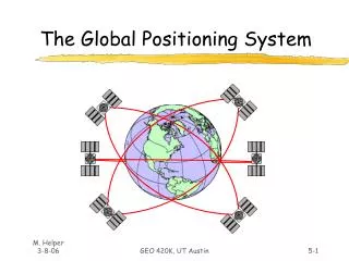
The System • 24+ satellites operated by USAF provide 24-hour, all-weather, global coverage • Satellites are equipped with atomic clocks • Precise time signals are broadcast on L-band radio frequencies • Four satellite signals enable receivers to triangulate position
How It Works • Satellites broadcast • • Precise time • • Orbit data • • Satellite health • Receiver measures time delay from satellites, and by triangulation calculates • • Location • • Elevation • • Velocity
GPS is a Dual-Use System • Cold War spinoff • Developed in 1970s-1980s to support Allied forces • Prominent in Gulf War, Kosovo • After KAL-007, civilians gained free access to Standard Positioning Service • Commercial use now dwarfs military use • GPS policy is managed at a national level by the Interagency GPS Executive Board (IGEB)
Interagency GPS Executive Board Defense Transportation State Commerce Agriculture Interior NASA Joint Chiefs of Staff Justice
United States GPS Policy • Presidential Decision Directive signed in 1996, endorsed by Congress in 1998 • GPS Standard Positioning Service to remain free of direct user fees • U.S. to promote acceptance and use of GPS as a world standard • Selective Availability -- ended May 2000 • IGEB to manage GPS as a national asset
United States GPS Policy, cont’d. • Encourage private sector investment in/use of GPS technologies and services • Promote safety and efficiency in transportation and other fields • Promote international cooperation in using GPS for peaceful purposes • Advance scientific and technical capabilities • Strengthen and maintain national security
Worldwide GPS Hardware Sales Expected to Exceed $9B by 2002 (Projected) $Billions Source: OSC, 2001
Global Sales by Market Segment $ Millions Source: ITA, 1998
Car Navigation • On-board navigation • Fleet management • Roadside assistance • Stolen vehicle recovery • Enhanced services • Mass market dominated by Japan • Dataquest: Unit sales of chips for car navigation to reach 11.3M in 2001
Consumer/Recreational • Portable receivers for fishermen, hunters, hikers, cyclists, etc. • Recreational facilities -- golf courses, ski resorts • Integration of GPS into cellular phones • E-911 requirement
Surveying/Mapping/GIS • Sub-centimeter accuracy • 100%-300% savings in time, cost, & labor • Control survey point: $10,000 in 1986; $250 in 1997 • Rural electrification • Telecom tower placement • Pipelines • Oil, gas, and mineral exploration • Flood plain mapping
Tracking/Machine Control • Package/cargo delivery • Fleet and asset management • Theft recovery • Public safety and services • Farming, mining, and construction equipment • DGPS/RTK required for many applications
Public Services • City planning • Transportation infrastructure • Road Billing Network (ROBIN) • Snowplows • Emergency response • Law enforcement • Fire fighting • Search and rescue • Paramedics • Disaster relief
Aviation • GPS approved for en-route navigation • More efficient flight routing leads to fuel savings • Better tracking of aircraft enhances safety • Closer spacing of planes increases airspace capacity
Maritime Navigation • GPS-based vessel tracking and traffic management maximizes effectiveness of waterways • Improved safety increases maritime commerce • Maritime DGPS service for enhanced accuracy and safety available in 34 countries
Original Equipment Manufacturers • Chipsets • Electronic boards • Antennas, components • Standalone receivers
Military • GPS is a recognized NATO standard • GPS is required on all U.S. military systems • Precision munitions widely used during Gulf War, Kosovo
Timing • GPS offers an inexpensive alternative to costly, high maintenance timing equipment • Telecommunications network synchronization & management • Phones, pagers, wireless systems • LANs, WANs, Internet • Financial transactions • Electrical power grid management & fault location • Digital signatures for e-commerce
Scientific Research • Monitoring geological change • Glaciers, tectonic plates, earthquakes, volcanoes • Wildlife behavior • Atmospheric modeling • Water vapor content • Oceanic studies • Tidal patterns • Surface mapping • Time transfer
Environmental Management • Forestry • Wetlands management • Natural resource management • Fisheries boundary enforcement • Endangered species and habitat preservation • Hazardous material cleanup • Oil spills, toxic waste
Emerging GPS Applications • Entrepreneurs and scientific researchers invent new applications almost every day • Higher precision is necessary for many cutting-edge applications • Differential GPS (DGPS) • Relative DGPS • Carrier phase positioning • Real-Time Kinematic (RTK) • Post-processing
Precision Agriculture • Maximize use of resources • Optimized plowing of crop rows • Tailored applications of seeds, fertilizer, water, pesticides • Improved management of land, machinery, personnel, time • Greater crop yields • Net benefit: $5-14 per acre • Minimize environmental impacts • Localized identification and treatment of distressed crops reduces chemical use • Precise leveling of fields prevents fluid runoff
Open Pit Mining • Enhanced management of assets, equipment • Progress tracked in real-time, remotely • Improved machine control saves time, lowers maintenance and fuel consumption, prevents accidents • Rapid surveying for drilling blast holes • Smaller, more empowered workforce
Space Applications • Improved orbit and attitude control for spacecraft, International Space Station • Space Station return vehicle • Advance Land Observing Satellite uses GPS to calibrate high resolution radar maps • Satellite formation flying • Space launch range safety
Construction • Machinery, asset, and personnel management • Rapid surveys for laying foundation piles, etc. • Accident prevention • Remote control of machinery possible • Japanese volcano dam GPS/RTK technology was used in the construction of the Øresund Bridge between Denmark and Sweden
The Market is Wide Open • Civil signals are freely available, right now • Openly published GPS specifications allow anyone to build receivers (no licensing fees) • Hardware is becoming a commodity • Huge potential exists in value-added services • Software development • Embedded applications • Localized GIS databases • Internet integration • Wireless markets
Unit Cost of Receivers is Falling at ~30% Per Year $800 $600 $400 $200 0 1991 1993 1995 1997 1999 Source: GPS Industry Council, 1995
Relative Market Share Projections Source: ITA, 1998
Background • 1996 Presidential Decision Directive (PDD) and 1998/99 Vice Presidential announcements committed US to modernization and improvement path • Selective Availability (SA) turned to zero NLT 2006 • Two new civil signals and new military signals • Free world-wide use • Move from studies to action initiated in FY 2000 • SA discontinued in May 2000 • Deputy Secretary of Defense directed changes to existing and future satellites • OMB directed TOA transfer from DoT to DoD • Block IIF program terminated at 12 satellites and GPS III development began Modernization Now in Full Swing
C/A P(Y) P(Y) M M L2C C/A P(Y) P(Y) M M L2C C/A P(Y) P(Y) Modernized Signal Evolution Present Signal (Block II/IIA/IIR) 2nd Civil; M-Code Block IIR-M 3rd Civil Block IIF 1176 MHz (L5) 1227 MHz (L2) 1575 MHz (L1)
Second Civil Signal (L2C) - Block IIR-M Satellites First launch in 2003, then every satellite thereafter Provides a redundant signal for civil users Improved continuity in case L1 signal reception is lost Improved accuracy via dual-frequency ionosphere correction Wide-lane for extremely-precise local area differential GPS Third Civil Signal (L5) - Block IIF Satellites First launch in 2005, then subsequent satellites thereafter Provides redundant dual-frequency capability for civil users Improved continuity in case L1 or L2 signal reception is lost Improved accuracy via triple-frequency ionosphere correction Tri-lane for ultra-precise local area differential GPS Provides an interference-resistant signal for civil users New Civil Signal Rollout
New Civil Code on L2 • Advantages of a New Signal • Improved cross-correlation properties • Improved tracking capability -- 3dB higher power than Coarse Acquisition (C/A) on L2 • Signal Characteristics • Two codes: one with data (medium code); one without (long code) • Codes longer than C/A code to minimize cross correlation • Separated by time -- Time Division Multiplexed (TDM) • Overcome some limitations of current C/A coded signals
Basic Positioning: Today 6-10 m • C/A Code on L1 Before May 2000: 25-100 m
Basic Positioning: Tomorrow Better resistance to interference 1-5 m Eliminates need for costly DGPS in many non-safety applications • C/A Code on L1 • L2C Code on L2 • New Code on L5
Advanced Positioning: Today 10 km 2 cm accuracy • L1 Code and Carrier • L2 Carrier • Data Link
Advanced Positioning: Tomorrow Faster recovery following signal interruptions (ex., under bridges) 100+ km 2 cm accuracy Fewer base stations needed • L1 Code and Carrier • L2 Code and Carrier • L5 Code and Carrier • Data Link
FIX FOM 1 N 42* 01” 46.12” W 091* 38’ 54.36” EL + 00862 ft 3 menu 1 ON 2 4 5 6 7 WPT 8 POS 9 NAV CLR MARK 0 OFF NUM LOCK ZEROIZE Rockwell GPS III The GPS III System Maintain Space User Service Second Civil Signal Third Civil Signal • Relook at entire GPS architecture to: • Achieve long term GPS performance goals • Reduce long term total ownership costs • Ensure GPS is synergized with • Military and civil needs/systems • Possible augmentation opportunities • Build best GPS system for the next 30 years
GPS Modernization at a Glance Increasing System Capabilities Increasing Civil/Defense Benefit NAVWAR Capable Full Civil Rqmts Add’l Capabilities New Civil Signal – L5 L2C on L2 M-Code (Earth) SA Set to 0 Basic GPS GPS III • GPS-III: • Improved Anti-jam (+20dB) • Increased Accuracy • Greater Availability • Controlled Integrity • Greater Survivability • Other Transformational needs • Blue Force Tracking • Nav-related Messaging • Responsive Ops GPS IIA/IIR GPS IIR-M, IIF • Standard Service (~100 m) • Precise Service (~16 m) • Two Nav frequencies • L1: Civil (C/A) &Precise (P) Code • L2: P-Code • IIR-M: Improved on all IIA capabilities and added • 2nd Civil Signal on L2 • New L1 & L2 M-Code • IIF: IIR-M capability and: • Add 3rd Civil Signal on L5
International Cooperation • U.S. GPS Policy of 1996 directed State Department to pursue cooperation with other nations to promote peaceful uses of GPS, establish it as world standard • Talks occurred with Russia (GLONASS), Japan (MSAS), Europe (EGNOS) • September 1998: Joint statement on GPS cooperation signed with Japan
U.S. Principles for Cooperation • Seamless interoperability with GPS • No direct user fees for safety critical services • Open market access (non-discrimination) • Equal access to signal specifications • Equal access to user markets (free trade) • Market driven competition • Free choice for end users • Spectrum protection • Protection of national security interests
Official U.S. Position on Galileo • Modernized GPS service will be sufficient to meet user needs worldwide • If Galileo does proceed, the U.S. could see benefits if it is designed to be truly interoperable with GPS • U.S. is waiting to see what path Galileo takes -- many open questions remain unanswered • Basic U.S. position has not changed since first articulated in 1999
Unanswered Questions about Galileo • How viable is the business case? • Will European governments help generate revenue streams through regulations and standards that effectively mandate use of Galileo? • Will Galileo signals interfere with GPS? • Will the information needed for receiver production be made equally available to all manufacturers? • Will Galileo take on a strategic military role? • How will Europe prevent hostile misuse of Galileo?
Additional Questions • Will the encrypted levels of service be truly interoperable with the free, safety-of-life services? • As EGNOS becomes integrated into Galileo, will it continue to provide GPS data vital to aviation? • How will Europe protect the sensitive encryption technology used?