Download
1 / 14
150 likes | 157 Views
Real-Time Mesoscale Analysis Review and Plans for Rapid Updating Analysis. Jason Levit NOAA NextGen Weather Program June, 2013. Agenda. RTMA Evolution: 2006 Today Drivers for RTMA Background Development Organization Analysis Domains and Resolution RTMA Techniques

E N D
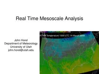
Real-Time Mesoscale Analysis Review and Plans for Rapid Updating Analysis Jason Levit NOAA NextGen Weather Program June, 2013
Agenda • RTMA Evolution: 2006 Today • Drivers for RTMA • Background • Development Organization • Analysis Domains and Resolution • RTMA Techniques • Plans for Near Term Enhancements to RTMA • Plans for Long Term Transition to Rapid Updating Analysis • Characteristics of the Multiple-Radar Multiple-Sensor project • Discussion
RTMA 2006 - Today Drivers for RTMA Development: • Verification of NDFD forecasts • Initialization of gridded forecasts at Weather Forecast Offices • Situational awareness for sensible weather Background: • Requirements defined in OSIP • Initial analyses for CONUS in 2006 • OCONUS analyses added in 2008 • Official NWS product in 2011 • NextGen Program funding in FYs 2010 and 2011 Development Organizations: • NCEP, Environmental Modeling Center • Geoff DiMego, Federal Manager • Manuel Pondeca, Developer • Steve Levine, Developer • Yanqiu Zhu, Developer • Stan Benjamin, ESRL/GSD, Developer
Analyses + Resolution + Domains Analyses: • Wind Speed and Direction • Temperature • Dew Point Temperature • Surface Pressure • Effective Cloud Amount – (remapped GOES by NESDIS) • Accumulated precipitation (remapped Stage 2 by Ying Lin) Analysis Uncertainty: • Temperature • Dew Point Temperature • Wind Speed • Wind Direction Cross-validation: • A subset of observations are withheld • Scores computed for each analysis Model Terrain: • Fixed field Hourly Domains: • CONUS (5 and 2.5 km) • Hawaii (2.5 km) • Alaska (6 km) • Puerto Rico (2.5km) 3 hourly Domain: • Guam (2.5km)
RTMA Techniques Analysis Generation: • First Guess obtained from Rapid Refresh downscaled to NDFD domain • First Guess at the Appropriate Time (FGAT) • Terrain following background error covariance • Gridded Statistical Interpolation (GSI) used in Two Dimensional Variation (2D Var) mode • Observations from Meteorological Assimilation Data Ingest System (MADIS): • Satellite derived winds • ASOS – METAR • Mesonet • Buoy, ship, tide gage and Coastal-Marine Automated Network (CMAN) • Approximately 15,000 observations used per analysis • Quality control of observations beyond that done in MADIS: • Gross error check • Predefined reject list of sites from WFOs • Reject selected mesonet winds
Cross-Validation • Make multiple disjoint datasets for each ob type, each containing about 10% of the data. Datasets contain representative data from all the geographical regions observed but without the redundancy of close pairs or tight clusters • For each analysis, randomly pick one of the disjoint datasets to use for cross-validation
PARALLEL RTMA CONUS-2.5 km Note: Analyzed at the 10-m level
RTMA Enhancements Planned 2013 • 3 km Analysis upgrade for Alaska • 1.5 KM Analysis domain for Juneau • 2.5 km Analyses for Northwest RFC domain • Science and quality control technique improvements: • Improved handling of snowpack in RAP • Winds from Hurricane WRF added to improve analyses of tropical cyclones • New analysis variables: • Wind gusts • Visibility
Next Steps for RTMA Development Explore potential for additional Aviation impact analysis variables: • Total cloud cover • Cloud base heights • Mean sea level pressure Continue to enhance quality control of observations: • Real-time monitoring system • Real-time data mining • Add metadata into GSI • Improved Land sea mask Delayed Mesoscale Analysis: • Run 4 hours after RTMA • Collects more complete set of observations • Improved product verification • RTMA will continue to be available • Enables transition to Analysis of Record capability
Transition to Rapid Updating Analysis Rapid Updating Analysis (RUA) • Benefits: • Enhance forecaster situational awareness • Enable issuance of warnings and forecasts with greater lead time and accuracy • Provide a more accurate data set for model and forecast verification • Concepts: • Updated every five minutes • 1km horizontal resolution • Expands coverage to atmosphere • Uses satellite, radar and soundings (aircraft, etc.) • Phased Implementation: Use the MRMS in the initial phase and then moving to a GSI-based system • Multiple-Radar-Multiple-Sensor (MRMS) system serves as the initial backbone • VIL • Vertical wind shear • Precipitating species (hail) • Lightning • Reflectivity and radar quality • (see spreadsheet for list of variables) • Products will execute on NCEP mainframe • At full capability, will generate the most state-of-the-art analyses of the atmosphere currently possible, with the best scientific techniques • RUA data will serve as both a real-time analysis and eventually as initialization for high resolution models for Warn-on-Forecast applications • Utilizes the GSI framework for code compatibility across NOAA
What is MRMS? • MRMS = Multiple-Radar / Multiple-Sensor • Multi-Radar: Exploits the overlapping coverage of the WSR-88D network and the Level-II real-time data feeds to build a seamless rapidly-updating high-resolution three-dimensional cube of radar data. • Multi-Sensor: Objectively blends data from the multiple-radar 3D cubes with surface, upper air, lightning, satellite, rain gauges, and NWP environmental data, to produce highly-robust decision assistance products. • Improvements demonstrated in QPE, severe weather diagnosis, warning decision efficiency, NWP, etc. MRMS
MRMS Outputs • 3D Reflectivity CONUS cube • 3D Azimuthal Shear CONUS cube MRMS