Download
1 / 35
350 likes | 459 Views
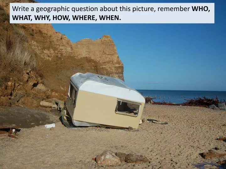
Write a geographic question about this picture, remember WHO, WHAT, WHY, HOW, WHERE, WHEN. Coastal landforms are subject to change. What is happening to the British Coastline?. Starter- Watch the video …. What are some of the threats to the coastline? What issues may this cause?.

E N D
Write a geographic question about this picture, remember WHO, WHAT, WHY, HOW, WHERE, WHEN.
What is happening to the British Coastline? Starter- Watch the video…. • What are some of the threats to the coastline? • What issues may this cause?
Which area of the UK may be the most at risk from Coastal erosion?
Is fetch going to be the only factor? GEOLOGY/ROCK TYPE But…the predominant rock type in the SW is Granite slowing down the rates of erosion FETCH Coasts that face a major ocean (i.e. The SW of the UK facing the Atlantic Ocean have a very large fetch so produce destructive waves Factors affecting coastal erosion COASTAL DEFENCES if effective coastal defences are put in places this may slow the rate of recession
What are the effects of coastal recession on people and the environment • The amount of effect is determined by land use- if the area affected by cliff recession is used for settlement, the effect is greater than if used by farmland.
Case study: Holderness Coast The Holderness coast is 61km long in the north east of England. This is one of the most vulnerable coastlines in the world and it retreats at a rate of one to two metres every year.
Location and local details (map) Causes of Coastal Erosion (both physical and human) Effects of Coastal Erosion People: Environment: The Holderness Coast Case Study Key ideas: effects on people buildings infrastructure, short and long term effects, financial and social effects Key words wave strength and fetch, rock type, weathering, slumping, longshore drift, coastal defences
Case study: Holderness coastline • http://www.youtube.com/watch?v=J-VzLG15yMQ
What processes are acting upon this coastline? Geology Map of Holderness Altitude Map of Holderness How might the geology of the area affect the shape of the coastline?
The problem is caused by 4 main reasons: • - Strong prevailing winds creating longshore drift that moves material south along the coastline. • - Naturally narrow beaches. Beaches slow down waves, reducing their erosive power and acting as a barrier. Narrow beaches give less protection towards the coast. • - The cliffs are made of a soft boulder clay. It will therefore erode quickly, especially when saturated.
2. Mappleton Situated approximately 3km south of Hornsea lies the village of Mappleton. Supporting approximately 50 properties, the village has been subject to intense erosion at a rate of 2.0m per year, resulting in the access road being only 50m from the cliff edge at its closest point. Mappleton lies upon unconsolidated till (boulder clay). This material was deposited by glaciers during the last ice age 12,000 years ago.
Case Study: Holderness coast erosion impacts Impacts on people: • Homes near cliffs are at risk of collapsing into the sea which means insurance is literally impossible to get. • Property prices have fallen • The gas terminal in Easington is at risk as it’s only 25m from the cliff and it counts for 25% of Britain's gas supply. • Accessibly to settlements have been affected along the coast as roads have collapsed into the sea, Impacts on environment: • Some sites of special scientific interest (SSSI’S) have been threatened e.g. Lagoons near Easington. The lagoons are separated from the sea by a narrow bar however if the bar is eroded the lagoons will be destroyed.
Solutions • In 1991, the decision was taken to protect Mappleton. A coastal management scheme costing £2 million was introduced involving two types of hard engineering - placing rock armour along the base of the cliff and building two rock groynes. Mappleton and the cliffs are no longer at great risk from erosion. • The rock groyneshave stopped beach material being moved south from Mappleton along the coast. However, this has increased erosion south of Mappleton. Benefits in one area might have a negative effect on another. • The increased threat of sea level rise due to climate change, means that other places will need to consider the sustainability of coastal defence strategies for the future.
Mappleton Mappleton is an excellent case study of an attempt at coastal management. In 1991 two rock groynes and a rock revetment made from huge blocks of Scandinavian rock were built. As a consequence a substantial beach accumulated between the groynes halting erosion (picture 1 below). However, further south the rate of erosion has increased significantly (picture 2 below). This is because material which is being carried south is not being replaced (it is trapped within the groynes). Therefore there is no beach to protect the cliffs. Even during a neap tide ( a tide which is 30% less than the average tidal range) the sea reaches the base of the soft cliffs and erosion occurs. 1 Cliffs to the north. Sea defences mean that the beach has grown and the cliffs are stable (look at the grass growing!) 2 Cliffs to the south. The sea defences don’t protect this area and the land is retreating rapidly.
Mappleton Southern section No defences = Beach erosion Northern section Defences = Beach build up
3. Aldbrough Aldbrough is a small settlement to the south of Mappleton. Where Mappleton had substantial sea defences built, Aldbrough has none. The cliffs here are rapidly eroding. Some residents think that the sea defences at Mappleton has made things worse. Why would they think this?
4. Withernsea This settlement attracts tourists, so substantial sea defences have been constructed to maintain the beach. How many sea defences can you see in this picture?
5. Kilnsea The old settlement of Kilnsea has now been completely lost. Sea defences were built here in the early 1900s to protect the Godwin Battery - a defensive gun emplacement and the rail-head for a light railway to further military installations on Spurn point. The sea defences are now crumbling and erosion is progressing rapidly.
Kilnsea Old map of Kilnsea Current aerial photo of Kilnsea
6. Spurn Head The area known as Spurn forms the southern extremity of the Holderness coast and includes the unique feature of Spurn Head, a sand and shingle spit 5.5km long, reaching across the mouth of the Humber. Spurn is made up of the material which has been transported along the Holderness Coast. This includes sand, sediment and shingle. Spurn Point provides evidence of longshore drift on the Holderness Coast. It is an excellent example of a spit. How would sea defences along the coastline affect Spurn?
Spurn Head • The material eroded from the Holderness cliffs is swept southwards. • North easterly waves move the coarser sands and gravel down towards the mouth of the Humber • The finer sands and clays are swept offshore and continue southwards towards the Wash. • Spurn Head ‘hangs like a rudder’ for six kilometres off the end of Holderness, built by the sands and gravels eroded from the cliffs and transported south by longshore drift • In the past Spurn Head seems to have grown and been washed away in a regular cycle, slowly moving towards the east to keep pace with the erosion of the Holderness cliffs. • For over 100 years the position of Spurn has been fixed by artificial sea defences. These defences are now falling into disrepair and the sea is starting to erode parts of the peninsula once again.
Coasts : Features of Deposition / Issues of coastal protection of a Spit 16 The thin neck of Spurn Head is only a few metres wide. Victorian coastal engineers tried to stop the spit eroding away at its thinnest point over a hundred years ago, but their wooden groynes have now collapsed and are no longer effective. The issue is whether to protect the spit from further erosion, or let the sea carry out its operations, and erode it away. Key Terms : Longshore Drift Deposition feature Spit Estuary • Issues if the spit is allowed to be eroded away: • The 7 homes of Britain’s only full-time lifeboat crew of the Humber lifeboat are located at the southern end. They would have to be relocated – possible to Grimsby if the spit eroded away – meaning a longer journey time into ships in distress in the N. Sea • The Humber pilots are based there too – they go out to ships entering the Humber estuary – one of the busiest in Britain – to guide ships around the shifting and dangerous sand-banks of the estuary. • The spit is an important route for migrating birds from the continent which, in spring, use the spit to guide them into Britain, and in autumn on their flights south for the winter. • The Spit is managed by the Yorkshire Wildlife Trust and is a vital habitat for many plants & insects • Issues if the spit is protected from further erosion • The costs of protecting the entire length of the spit would be huge. • The Victorian attempts to keep the spit in one position have increased its current problems as the Holderness coast to the north continues to erode westwards – leaving the spit more exposed to NE winds and waves. • The erosion of material from the spit provides important material to help protect the beaches south of the Humber in Lincolnshire and even the Netherlands. Stopping the erosion and movement of this material from Spurn would cause faster erosion elsewhere. Example / Case-Study : Spurn Head, E. Yorkshire (Spit) Possible Questions : Why are there disagreements about whether to protect coasts from further erosion? What are the issues surrounding the management of sensitive coastal environments?
Spurn Head Spurn Head changes position. Most of the spit has flexible road surfaces, which are like mats that can be picked up and moved following major storms. There is plenty of evidence of this movement. Former railway tracks that were built to move building materials along Spurn (for the building of Bull Fort in the Humber Estuary) now appear to lead into the sea.
Spurn Head Is Spurn eroding? The end of Spurn is fairly stable. This is due to it’s size and the presence of deep rooted plants. The rest of Spurn erodes and moves constantly. There are some groynes to protect it, but these are very old now.
Spurn Head Is it important to protect access to Spurn Point? Full time lifeboat men live here with their families. The Humber estuary is very busy with large ships. It is one of the most dangerous estuaries in Europe, so pilots guide boats in and out. Their base is on Spurn for quick access to sea. The pilots do not live on Spurn. Spurn is also important for birds and wildlife.
Another case study…for comparison Choose 1 of the case studies scanned into the wiki… Complete case study notes (but briefer!) to complement the Holderness case study