Download
1 / 5
50 likes | 61 Views
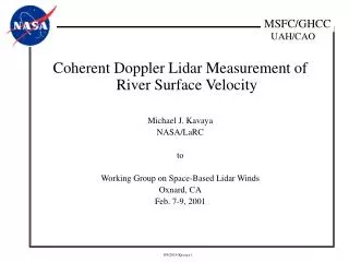
This animation concept explores the visualization of wind data from Doppler Wind Lidars, providing visual confirmation of shot patterns and optimized mission parameters. The STK software by AGI offers 2D or 3D views, accurately depicting orbit geometry and scan patterns in a user-friendly manner. This animation complements more detailed animations with approximate geometry and showcases dual perspectives.

E N D
Conceptual Animations of Space-Based DWL Tropospheric Wind Measurements Michael J. Kavaya NASA/LaRC to Working Group on Space-Based Lidar Winds Oxnard, CA Feb. 7-9, 2001
Motivation • Explanation of wind data product from Doppler Wind Lidars • Visual confirmation of intended shot pattern • Understanding for mission parameter optimization
STK Software by AGI • 2-D or 3-D views • Geometrically correct • Orbit geometry correct • Scan pattern correct • Fore shots blue; aft shots red • Easy modification • Easy production of movies • Complementary to fancier animations having approximate geometry
Kavayats • Lidar azimuth angles = 44, 134, 226, and 316 deg. for visibility of dual perspectives • Unable to properly show laser radiation emission duration and propagation • No attempt made to co-register dual perspectives in along-track direction (precise scanner programming) • Laser beam spread angle and ground spot size greatly enlarged in all but close-up views
Future • Other numbers of wind tracks per orbit; numbers of lidar shots per LOS per perspective; laser PRF; horizontal resolution • Special scan patterns for single location saturation • Continuous scanning • More than one satellite • Ground and airborne cal/val opportunities: • vs. co-location gap • vs. latitude • Sequential over flight of multiple locations