Download
1 / 32
330 likes | 525 Views
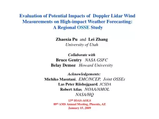
Potential Impacts of a Space-based Doppler Wind Lidar. G. D. Emmitt and S. A. Wood Simpson Weather Associates R. Atlas (NOAA/AOML) J. Terry (NASA/GSFC) AMS 88 th Annual Meeting 20-24 January 2008. Outline. Description of a proposed Doppler Wind Lidar to meet need for global wind soundings

E N D
Potential Impacts of a Space-based Doppler Wind Lidar G. D. Emmitt and S. A. Wood Simpson Weather Associates R. Atlas (NOAA/AOML) J. Terry (NASA/GSFC) AMS 88th Annual Meeting 20-24 January 2008
Outline • Description of a proposed Doppler Wind Lidar to meet need for global wind soundings • Brief overview of OSSEs in general • Summary of some past DWL OSSE results • Global • Regional • Current simulations for planned OSSEs
Motivation • The NWP communities and the NPOESS program have identified 3D global tropospheric (and stratospheric) winds as having the highest priority as a new observing capability. Global tropospheric winds are NPOESS’s #1 unaccomodated EDR. • The NRC Weather Panel determined that a Hybrid Doppler Wind Lidar (DWL) in low Earth orbit could make a transformational impact on global tropospheric wind analyses. • Computer modeling studies at NCEP, NASA and ESA have shown that 3D tropospheric wind profiles are critical to advancing operational forecasting skills. • Cost benefit studies show that global 3D wind observations would have significant cost/safety impacts on aviation (> $100M$/yr), severe weather preparation (evacuation cost avoidance > 100M$/yr) and military operations (>15M$/yr).
Global Wind Observing Sounder (GWOS) • Space-borne hybrid Doppler Wind Lidar • Includes both aerosol coherent (lower troposphere) and molecular direct detection (mid- and upper troposphere) measurement systems • First space-borne Doppler Wind Lidar to provide true vector winds • ADM/Aeolus provides LOS winds for one direction only • Several independent simulation studies have shown vector wind information to be more useful for data assimilation
Proposed Initial DWL MissionConcept • Demonstrate instrument architecture • Hybrid DWL • Direct detection for molecular backscatter • Coherent detection for aerosol backscatter • 2 tracks, bi-perspective • < 3 m/s HLOS accuracy throughout troposphere • 0-20 km altitude (higher with more averaging) • Employ adaptive targeting (optional) • < 100% duty cycle to reduce platform power requirements and extend laser lifetimes • Select high NWP impact targets
GWOS Coverage • Around 600 radiosonde stations (black) provide data every 12 h • GWOS (blue) would provide ~3200 profiles per day
Vertical Distribution of GWOS LOS Observations GWOS with background aerosol mode Direct Coherent GWOS with enhanced aerosol mode Coherent Direct
Vertical Distribution of “Best choice” LOS Observations GWOS with background aerosol mode Dual sampling with the coherent and direct detection molecular Global Wind Observing Sounder (GWOS) GWOS with enhanced aerosol mode Green represents percentage of sampled volumes when coherent subsystem provides the most accurate LOS measurement; Yellow is for direct detection; Gray is when neither system provides an observation that meets data requirements due to signal strength or cloud obscuration
GWOS Synergistic Vector Wind Profiles* Green: both perspectives from coherent system Yellow: both perspectives from direct molecular Blue: one perspective coherent; one perspective direct Enhanced aerosol mode Background aerosol mode 50% more vector observations from hybrid technologies Coherent aerosol and direct detection molecular channels work together to produce optimum vertical coverage of bi-perspective wind measurement *When two perspectives are possible
Basic OSSE definition • Model based experiments designed to test hypothesized impacts of future observing systems on numerical weather prediction (NWP).
OSSE Objectives (1) • Provide quantitative basis for defining the optimal mix of sensors for NWP • Assess potential analyses/forecast impacts of new observing systems under consideration for deployment • Provide feedback to the instrument developers including rationale for descoping
OSSE Objectives (2) • Accelerate transition of observations from newly developed instruments to operational use • Enables the JCSDA to develop data processing and assimilation software prior to the launch of the new instrument • Provide the operational community early insight to synergisms with other instruments
OSSE Rules • Proposed by Kalney, Halem and Atlas (1986) • Fraternal Twin vs. Identical Twin models • Realism checks • Calibration checks • Simulation of existing sensors • Simulation of imagined sensors
Definitions & Hierarchy • Observing System Simulation Experiment (OSSE) • Observing System Experiment (OSE) • OSSE-Like Experiments • Rapid Observing System Simulation Experiments (ROSSEs) • Quick OSSEs (QOSSEs) • Simple OSSEs (SOSSEs) • Partial OSSES (POSSEs)
OSSE TESTBED COMPONENTS Recent New T213 Validation of End - to - End OSSE Set - up GLA .5 ° ECMWF T511 - Realism of simulated observations and input GLA .25° ECMWF T799 - Impact model not too close to NR Global DAS (including LOS) Impact Simulated Observations Nature Runs Model GSI Current Future Regional Globa l Scatterometer DWL WRF GFS Rawinsonde CMIS HWRF FV Validation and Surface Molnya ETA ACARS UAV Augmentation TOVS CL Balloon AIRS GPS Sounding CMV Buoy Rocket OSSE Metrics Valid. Aug. Cyclones Clouds Cyclones Anomaly Correlation Mean fields Aerosols Fronts Spectral Binning Clouds Turbulence Jets Air Traffic Routing Precipitation Precip . Utility Load Mgmt.
Forecast hours • Scanning significantly increases the impact • In NH, DWL with scanning is required to produce additional skill over existing data • Non-scan DWL may produce significant impacts in NH with radiance data The diagram is anomaly correlations with nature run for 200mb V.Improvement in forecast skill with respect to forecasts with RAOB and surface data only. Skill for Northern Hemisphere synoptic scale events are presented. The resolution of DA is T62. Highlight of the Results from DWL OSSEs %
Adaptive Targeting Adaptive targeting with emphasis on CONUS interests ( Blue is coherent coverage Red is both coherent and direct) Adaptive Targeting Experiments Example of targeting a hurricane as it approaches the Gulf coast. (blue segments: forward looks; Red segments: aft looks; Blue plus red Provide full horizontal wind vector)
Potential Impact of new space-based observations on Hurricane Track Prediction Based on OSSEs at NASA Laboratory for Atmospheres Tracks Green: actual track Red: forecast beginning 63 hours before landfall with current data Blue: improved forecast for same time period with simulated wind lidar Lidar in this one case Reduces landfall prediction error by 66% DWLs greatly improve hurricane track predictions Courtesy R. Atlas
Relationship between Global and Regional OSSEs Nature Run Assimilation Run Global Assimilation Run (GFS) Global Nature Run (ECMWF) Simulated Observations Global Boundary Conditions Boundary Conditions Regional Nature Run (MM5) Regional Assimilation Run (RUC) Simulated Observations Regional
Non-raob init time (06z,18z) Raob init time (00z,12z) 6- hour forecast Assimilation of lidar observations(but no lidar obs in boundary conditions) • Lidar obs improve fcst more at non-raob init times • Lidar obs improvement greatest aloft Impact of adding lidar obs on 6-h fcst vector wind RMSE % degradation % improvement
Assimilation of lidar observations+ lidar obs in boundary conditions Raob init time (00z,12z) Non-raob init time (06z,18z) • ~8% mid-trop fcst T improvement for non-raob init • Less improvement near level of max ACARS impact Total lidar impact (assim + BC) on 6-h fcst temperature RMSE % degradation % improvement
Recent experience with OSSEsat NCEP and GSFC • Shifting focus to high impact weather forecasts and events for OSSE metrics • Precipitation forecasts • Hurricane track • Jet stream strength and location • Air traffic routing • Utility load management • Adaptive targeting (AT) OSSEs at NCEP (follow–on to earlier GSFC ATOSSE) • Hurricane lifecycle OSSEs at GSFC in collaboration with NOAA/AOML and GFDL
Summary • Global wind profiles are recognized as the #1 unmet NWP observational need • Impact studies over the past 20 years show significant impacts on NWP from a space-based DWL. • Laser technology is positioned to meet the challenge using hybrid detection technology
Review papers • Arnold, C. P., Jr. and C. H. Dey, 1986: Observing-systems simulation experiments: Past, present, and future. Bull. Amer., Meteor. Soc.,67, 687-695. • Atlas, R. 1997:Atmospheric observation and experiments to assess their usefulness in data assimilation. J. Meteor. Soc. Japan,75,111-130.