Download
1 / 1
20 likes | 185 Views
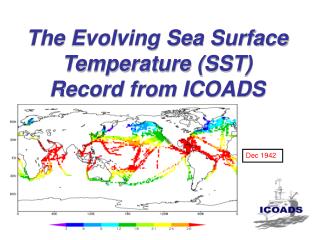
New Sea Surface Temperature (SST) ESDR Released Daily global SST map at highest resolution possible (1 km) “ MUR SST ” receives heavy usage in first 3 months of release. Who/What/Where/When/Why. Project and PI: Multi-Scale Ultra-high Resolution (MUR) SST Project , T. Mike Chin, JPL.

E N D
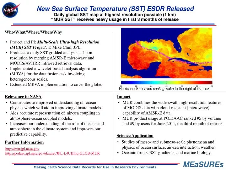
New Sea Surface Temperature (SST) ESDR Released Daily global SST map at highest resolution possible (1 km) “MUR SST” receives heavy usage in first 3 months of release Who/What/Where/When/Why • Project and PI: Multi-Scale Ultra-high Resolution (MUR) SST Project, T. Mike Chin, JPL. • Produces a daily SST gridded analysis at 1-km resolution by merging AMSR-E microwave and MODIS/AVHRR infra-red retrieval data. • Implemented a wavelet-based analysis algorithm (MRVA) for the data fusion task involving heterogeneous scales. • Extended MRVA implementation to cover the globe. Insert an image or graphic here that provides a visual complement to the narrative description of the impact or new ESDR described below. Hurricane Ike leaves cooling wake to the right of its track. Relevance to NASA Impact • Contributes to improved understanding of ocean physics which will aid in improving climate models. • Aids accurate representation of air-sea coupling in atmosphere-ocean coupled models. • Increases our understanding of the role of oceans and atmosphere in the climate system and improves our predictive capability. • MUR combines the wide-swath high-resolution features of MODIS data with cloud-resistant (microwave) capability of AMSR-E data. • MUR product usage at PO.DAAC ranked #5 by volume and #9 by users for June 2011, the third month of release. Science Application • Studies of meso- and submeso-scale phenomena and physics of ocean surface, air-sea interaction, weather. • Oceanic fronts, SST gradients, and marine biology. Further Information http://mur.jpl.nasa.gov http://podaac.jpl.nasa.gov/dataset/JPL-L4UHfnd-GLOB-MUR