Download
1 / 49
490 likes | 615 Views
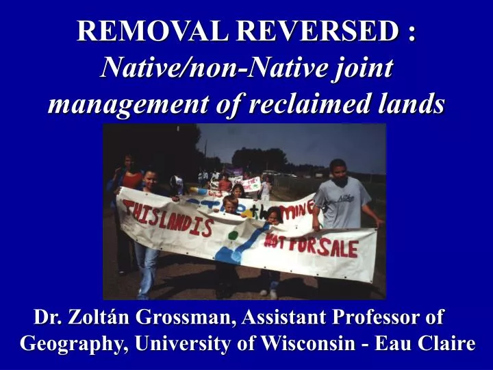
REMOVAL REVERSED : Native/non-Native joint management of reclaimed lands. Dr. Zoltán Grossman, Assistant Professor of Geography, University of Wisconsin - Eau Claire. Shared Space.

E N D
REMOVAL REVERSED : Native/non-Native jointmanagement of reclaimed lands Dr. Zoltán Grossman, Assistant Professor of Geography, University of Wisconsin - Eau Claire
Shared Space Hybrid space or “negotiated space”as relates to Native peoples and land use (Morris and Fondahl 2002, Waage 2001)Mainly co-management of ceded territory resources(NWIFC 1998, Ellsworth et al 1997)Natives and non-Natives removed from landscape Return for divided ownership, joint control
Shared Space Alleviate interethnic conflictCorrect past injustices Against Native people Against non-Native land-based peopleCommon source of place identityCommon goals for sustainability
Possible Wisconsin Precedents Ho-Chunk Nation - Closed munitions plant - Defeated dam projectWolf River tribes - Mole Lake Ojibwe, Potawatomi, Menominee - Defeated mine project
Ho-Chunk Nation Formerly Wisconsin Winnebago Tribe Origins in the effigy mound builders of Southern Wisconsin Agricultural people along waterways
Ho-Chunktreaties Strategic waterways Lead Rush of 1820s Rich farmland for settlement, 1830s Resistance to Indian Removal (Loew 2001)
Resistance to Removal Wazijaci (Dwellers Among Pines) hid out Many returned from new reservations Some white farmers actively opposed removal by 1870s
Ho-Chunk survival Wisconsin homesteads permitted, 1870s Poor in income and land Little federal interference with cultural autonomy
Ho-Chunk survival Purchased land parcels in 14 counties Tribal status in 1962 5,000 + members by 1990s Casino success in 1990s Casino near Wisconsin Dells
Ho-Chunk survival Using gaming revenue to acquire a few parcels 832 acres into trust by 1997 Federal trust relationship used for return of other parcels Muscoda bison ranch Whirling Thunder stables
KickapooReserve and SaukPrairieHo-Chunkceded lands inpurple;Present-daylands in red
KickapooValley Vernon County, Southwestern Wisconsin
KickapooValley Ho-Chunk sacred sites, rock art Very few Ho-Chunk remained after Removal Maintained visits to Kickapoo River
La Farge Dam Proposed 1961, but environmental opposition Local white residents removed from 14-mile stretch of river 8,600-acre site grew over; little dam construction Dam plans scuttled, 1975
Kickapoo Reserve Army Corps of Engineers promised to State for conservation, 1997 State promised to turn over 1,200 acres to Ho-Chunk Nation Entire 8,600-acre site under joint management, 2001
Kickapoo Reserve Ho-Chunk & farmers had common historyof forced removal Yet conflict over who is “local” Some resentment of DNR by former landowners
KickapooReserve division Joint land- use plan protects natural and cultural resources, enhances recreation
Kickapoo Reserve Management Board 11 member, appointedby Governor; State-fundedLocal majority principleRepresents State, Tribe, Local Communities, WatershedHo-Chunk own 1,200 acres
Kickapoo Reserve Management Board 2 3 4 2 STATE (3)At-large non-local agencyrepresentatives with expertise in resources, tourism, education.TRIBAL(2)Ho-Chunk Nation reps, one of whom is a watershed resident. LOCAL COMMUNITIES(4)Nominated from adjacent communities, school boards KICKAPOO WATERSHED(2)At-large members from watershed; not all adjacent. Executive Director runs KRMB.
Sauk Prairie Glacial outwash plainsouth of Baraboo HillsHo-Chunk farm fieldson rich soilFire management ofvast prairie for huntingNative Americansremoved, 1830s Sauk County, South-Central Wisconsin
Badger Ordnance WorksBuilt in WWII on some ofWisconsin’s richest farmland.Flat area with access to water and labor.
Removal of farmers, 1942 Sited Nov. 1941 oversites with poorer soilAccepted after Pearl Harbor Some of 90 landownersnot paid fair price7,400 acres evacuated;buildings torn down
Badger Army Ammunition Plant Made propellant for shells, bullets, rockets Open during WWII, Korea, VietnamMothballed 1975(Goc 2002)
Badger Army Ammunition Plant Nitrates contaminated groundwater (uninhabitable) Army clean-up begun Prairie grasses, birds, wildlife flourished above
Badger closure begins, 1998 Claims of Tribe (1,500 acres), Federal (USDA) over State (DNR). No local claim, but ex-residentfamilies want to have sayChoice between conservation/tourism and reindustrialization
Badger land use plan conflicts Tribe proposed prairie restoration, bison herd, cultural site protection State wanted full DNR control of contiguous site as parkTribe can pressure Army clean-up;critiques DNR track record Agricultural use on site
Conflict over who is “local” Ho-Chunk not treated as “local” (2nd highest tribal population) County gov’t opposed tribal role, feared casinoFrom federal land to trust land(no loss in local taxes) Tribe largest employer in county
Badger Re-Use Committee, 2001 State, tribal, federal governments divided ownership, possible joint management? “Uses and activities … contribute to the reconciliation and resolution of past conflicts involving the loss and contamination of the natural environment, the displacement of Native Americans and Euro-American farmers, and the effects of war.”
FutureownershipproposalsMost pollutedsites in north/central zoneHo-Chunksovereignty over tribal land
Proposed Crandon mine Zinc-copper shaft mine upstream of the Mole Lake Ojibwe Reservationand Wolf River in northern Wisconsin
Mine site ownership • Exxon proposed mine 1976, • bought land from small loggers • Withdrew 1986, returned 1992 • to face strong opposition • Withdrew again 1998, plans • kept for 4,800-acre mine site • Rio Algom or BHP Billiton (1998-2003); but low metal prices
Wetlands & springs in 4,800-acre mine site “You couldn’t find a more difficult place to mine.” -Exxon engineer
Environmental • Acidic runoff • Groundwater drawdown • Toxic processing • Economic • Boom-and-bust • Lack of local jobs • Threat to tourism/fishing • Cultural • Wild rice beds • Sacred sites • Influx of outsiders Objections to mine
Environmental groups • Urban mainstream • Rural grassroots • Students, unions, farmers • Sportfishing clubs • Had been anti-treaty • Local governments • Native American nations • Mole Lake Ojibwe • Potawatomi • Menominee • All resisted removal Alliance to stop mine
Company position, 2003 • Low metal prices • Wants to sell mine site, • but keeps permit process • Governor backs purchase • if price not too high
Alliance position • Public acquisition of 4,800 acres • Permanent protection from mining • Joint management of natural and cultural resources
Mix of public and private funds for acquisition? • How fund management?
Possible Wolf Headwaters Reserve Board Represent State, Tribes, Local Communities, Private Groups 15 members, appointedby each entity; rotating chairLocal majority principleMajority against mining(reflects alliance)
3 4 4 4 LOCAL COMMUNITIES (4) Forest County, Towns of Nashville and Lincoln, Langlade Co. or Town of Ainsworth PRIVATE GROUPS (3) Chosen collectively by private groups participating in acquisition; at least one from downstream county STATE (4)Dep’ts of Natural Resources,Tourism, Administration,State Historical SocietyTRIBAL(4)Mole Lake, Potawatomi,Menominee, GLIFWC
Land divided but joint managementReturn of the land to those who respect and care for it the mostPossible precedents for shared sovereignties (Khamisi 2001) Shared Space
Ho-Chunk Nation www.ho-chunknation.comKickapoo Valley Reserve kvr.state.wi.usBadger Re-Use Committee www.co.sauk.wi.us/badgereuseplanSauk Prairie Conservation Alliance www.saukprairievision.org Citizens for Safe Water Around Badger www.cswab.comMidwest Treaty Network www.treatyland.comWolf River Headwaters Protection Purchasewww.alphacdc.com/treaty/purchase.html
Ellsworth, JP, LP Hildebrand, and EA Glover. 1997. “Canada’s Atlantic Coastal Action Program: A community-based approach to collective governance.” Ocean & Coastal Management 36(2), 121-42.Goc, Michael J. 2002. Powder, People, and Place: Badger Ordnance Works and the Sauk Prairie.Friendship, Wis.: New Past Press.Ho-Chunk Nation and the State of Wisconsin. 1999. “Memorandum of Understanding Concerning the Badger Army Ammunition Plant.” (Dec. 11).Khamaisi, R. 2002. “Shared Space, Separate Geopolitically. “ Geoforum 33(3), pp 278-283.Loew, Patty, 2001. Indian Nations of Wisconsin: Histories of Endurance and Removal. Madison: University of Wisconsin Press, pp 40-53.Morris, P., and G. Fondahl. .2002. “Negotiating the Production of Space in Tl’azt’en Territory, Northern British Columbia.” Canadian Geographer 26(2).Northwest Indian Fisheries Commission (NWIFC). 1998. Comprehensive Tribal Natural Resource Management: A Report from the Treaty Indian Tribes in Western Washington.Smith, Susan L. 1997, “Ho-Chunk Land Returned in Kickapoo Valley.”Wisconsin State Journal (Oct. 29).Waage, Sissel A. 2001. “(Re)claiming space and place through collaborative planning in rural Oregon.” Political Geography 20(7), pp 839-858.Wisconsin Cartographers’ Guild. 1998. Wisconsin’s Past and Present: A Historical Atlas. Madison: University of Wisconsin Press.
Zoltán Grossman, Ph.D.Assistant Professor of GeographyP.O. Box 4004University of Wisconsin-Eau ClaireEau Claire, WI 54702Tel. (715) 836-4471 E-mail: grossmzc@uwec.eduWebsite: www.uwec.edu/grossmzc