Download
1 / 55
610 likes | 1.03k Views
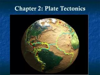
Chapter 9 Plate Tectonics. Sections 1-5 p. 248-270. 9.1 Continental Drift Wegener: Early Observations. German Scientist Alfred Wegener (1912) C ontinents had once been joined to form a single super continent Pangaea (‘all land’ ) S cientific hypothesis based on: Fossil evidence

E N D
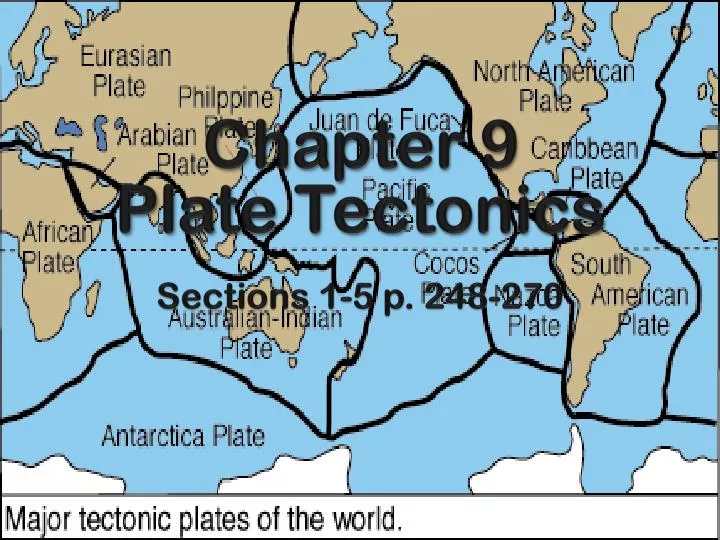
Chapter 9 Plate Tectonics Sections 1-5 p. 248-270
9.1 Continental DriftWegener: Early Observations • German Scientist Alfred Wegener (1912) • Continents had once been joined to form a single super continent Pangaea (‘all land’) • Scientific hypothesis based on: • Fossil evidence • Rock & mineral formations • Continental puzzle • Ancient climates
1. Fossil Evidence: Reptiles • Lystrosaurus: • Early Triassic Period (250 mya) • Land Animal • Antarctica, India, S Africa • Cynognathus: • Late Triassic Period • “Mammal-like reptile” • Land Animal • S Africa, South America, China, Antarctica
2. Evidence from Rock Formations • Similar rock types on opposite sides of the Atlantic Ocean. • Appalachian Mountains in the US identical to rock in Greenland and Europe.
3. Continental Puzzle • Similarity between coastlines on opposite sides of South Atlantic Ocean. • Did not take erosion into account Shows depth of 900 m; brown represents areas of overlap
4. Climate Evidence: Ferns & Coal • Certain climates support different fern types • Land connections were proved by same fossils on different continents • Coal in Northern US originated in an equatorial climate but drifted North over millions of years
4. Climate Evidence: Glaciers • Glacial deposits showing that between 220-300 myaice sheets covered large areas of S Hemisphere • Glacial till in S Africa, S America, India & Australia • Below till scratched bedrock carved by ice from sea to land unusual & supports continental drift • Glaciation areas lie near equator (subtropical/tropical)
Which was NOT a type of evidence Wegener used to support the theory of continental drift? a) rock and mineral formations b) climate evidence c) land shape d) vegetation species e) fossil evidence Be prepared to support your choice as to why these pieces of evidence are used to support the theory of continental drift.
Why wasn’t it accepted? • Problems with his theory: • Couldn’t explain how large land masses were pushed such great distances • Convection currents!
Accepted Today because: • Know that asthenosphere (lower mantle) has convection currents • Currents push magma which then pushes plates • Plates move at different rates • Move a few centimeters per year (roughly 5) • Not all pieces of plate move at same rate or same direction as the plate in general!
How fast do plates move relative to each other? a. millimeters per day b. centimeters per year c. meters per year d. centimeters per day
9.2/9.3 Plate Tectonics & Actions @ Boundaries • Uppermost mantle, along with the overlying crust, behaves as a strong, rigid layer lithosphere (divided into plates) • Do plates stay the same size and shape? • Asthenosphere weaker region of mantle • Plates include continents and large areas of the seafloor • Wegener thought that continents moved through the ocean floor not with it. • Plate movement driven by convection currents within asthenosphere
Plates can be either: Oceanic: thinner but MORE dense (sink) Continental: thicker but LESS dense (rise) Plate Movement • Earth’s crust: broken into about 12 major plates • Plates move several cm each year • Asthenosphere drives the plate • Slow moving layer • Convection currents
Types of Plate Boundaries Convergent boundaries : Compression forces push plates together Divergent boundaries: Tension forces move plates apart Transform boundaries: Shearing forces cause plates to slide against each other (opposite directions or same direction @ different rates)
Divergent Plate boundaries Processes: Hot magma rises to fill the 'gap' creating: new crust and mountain ranges forms themid-ocean ridge. Both earthquakes and volcanoes occur at this type of boundary. Rising magma can build up above ocean surface to create a volcanic island (for example Surtsey, Iceland). (ex. North American and Eurasian Plate form the Mid-Atlantic Ridge) Divergence Animation
Convergent Boundary Type 1 • Continental—Oceanic: denser oceanic crust subducts under continental crust. • Once oceanic plate melts as it is driven down, less dense material punches thru continental plate to create volcanoes or mountains on edge of continent • Forms a subduction zone and oceanic trench • Earthquakes occur as plate is subducted. • Ex: Andes Mtns and Peru-Chile trench
Oceanic—Oceanic: Olderand more denseplate sinks below the other. Ex. Kuril Islands and Marianas Trench: plunges deeper into the Earth's interior (~11,000 m) than Mt Everest, the world's tallest mountain, rises above sea level (~8,854 m).
EXAMPLES OF OCEANIC-OCEANIC CONVERGENT BOUNDARIES 1. Aleutian Islands, Alaska
Continental – Continental– ________ and more ________ plate sinks below the other. OLDER DENSE Cont-ContAnimation
EXAMPLES OF CONTINENTAL-CONTINENTAL CONVERGENT BOUNDARIES HIMILAYAN MOUNTAINS (like MT EVEREST and K2) The 10 highest mountains in the world are found here
* Convergent Boundaries create ____________ and ________________, especially around the _________ Ocean in the _______________. VOLCANOES EARTHQUAKES “RING OF FIRE” PACIFIC
TRANSFORM 3. ___________________ boundary: • Occurs where two plates slide past each other horizontally- along a fault Fault = a break in a body of rock. One block slides relative to the other (lots of friction) FAULT
TRANSFORM FAULT BOUNDARY What do you see? How did this happen?
EXAMPLE OF A TRANSFORM FAULT BOUNDARY San Andreas Fault- California/Mexico
A Review of Earth’s Interior and Plate Tectonics Video Oceanic/Oceanic or Oceanic/Continental subduction
What type of boundary is shown? a. an oceanic ridge b. a continental-continental boundary c. a transform boundary d. an oceanic-continental boundary
9.4 Testing Plate Tectonics • Several pieces of evidence discovered after hundreds of years of testing the theory of plate tectonics • Paleomagnetism: symmetrical bands of magnetized rock on ocean floor/volcanic regions • Earthquake Patterns: deep-focus earthquakes & ocean trenches • Ocean Drilling: age of oceanic crust • Hot Spots
1. Magnetism & Seafloor Polarity • Paleomagnetism: natural remnant magnetism in rock bodies • Permanent magnetization acquired by rock that can be used to determine the location of the magnetic poles ay the time it became magnetized. • Certain rocks contain iron-rich minerals (ex: magnetite): • Heated to certain temp. minerals lose their magnetism • Cooled to certain temp. magnetized in direction parallel to existing magnetic field • Similar to a compass needle!
Magnetism & Seafloor (cont) Polarity • But the Earth's magnetic field reverses every several thousand years • Creates new material on the sea floor which is oriented magnetically opposite the older material. • Flow changes→ magnetic reversal→ compass points S
Magnetism & Seafloor (cont) • Oceanic crust contains basaltic rock -contains large amts of Fe-bearing minerals • So it’s MAGNETIC! • This and the discovery of magnetic reversal led to the understanding that we can study rock samples far from ridge and understand what the core was like in magnetic polarity millions of years ago.
Magnetism & Seafloor (cont) • Ocean floor shows record of past reversals → imaginary “strips” along seafloor • Magnetometers are used to detect the “strips” • Found the “strips” are mirror images on either side of ridge→ symmetrical!! WOW!
2. Earthquake Patterns • Close link between deep-focus earthquakes and ocean trenches • When the depths of earthquake foci and their locations within the trench systems are plotted a pattern emerges • Most shallow focus EQ occur within or adj. to trench • Int. or deep focus occur toward mainland
3. Age of Rock (Ocean Drilling) • Rock NEAR ocean ridge= YOUNGER • Rock FAR from ocean ridge= OLDER • Oceanic rocks are relatively young (180 million years) compared to continental rocks (3.8 billion years) old • because oceanic is recycled (or “destroyed”) @ subduction zones • Thickness increases with distance from ridge
Isochron • Isochron→ imaginary line on map showing points that have same age (formed @ same time)
Approximately how long did the Gauss epoch last? a. 5 million years b. 3 million years c. 1 million years d. 100,000 years
Which epoch saw the most fluctuation between normal and reverse polarity? a. Gauss b. Matuyama c. Gilbert d. Brunhes
Which letter on the map shows the oldest seafloor? a) A b) B c) C d) D Be prepared to support why an isochron map provides evidence for seafloor spreading?
4. Hot Spots What is special about Hawaii?
9.5 Mechanisms of Plate Motion • Causes of plate motion: 1. Slab-Pull and Ridge-Push 2. Mantle Convection