Download
1 / 10
100 likes | 214 Views
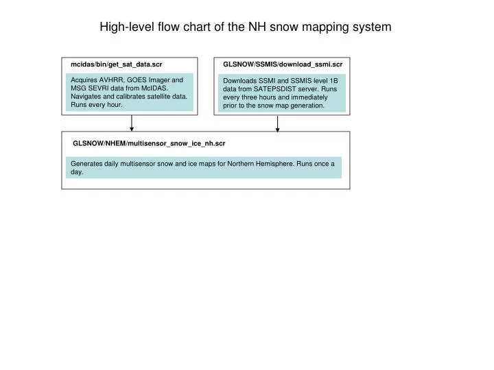
High-level flow chart of the NH snow mapping system. mcidas/bin/get_sat_data.scr. GLSNOW/SSMIS/download_ssmi.scr. Acquires AVHRR, GOES Imager and MSG SEVRI data from McIDAS. Navigates and calibrates satellite data. Runs every hour.

E N D
High-level flow chart of the NH snow mapping system mcidas/bin/get_sat_data.scr GLSNOW/SSMIS/download_ssmi.scr Acquires AVHRR, GOES Imager and MSG SEVRI data from McIDAS. Navigates and calibrates satellite data. Runs every hour. Downloads SSMI and SSMIS level 1B data from SATEPSDIST server. Runs every three hours and immediately prior to the snow map generation. GLSNOW/NHEM/multisensor_snow_ice_nh.scr Generates daily multisensor snow and ice maps for Northern Hemisphere. Runs once a day.
Acquisition of METOP AVHRR, GOES Imager and MSG SEVIRI data mcidas/bin/get_sat_data.scr mcidas/bin/avhrr_pass_mtp.scr avhrr_pass_mtp.pgm AVHRR McIDAS AREA files Acquires METOP AVHRR data from McIDAS. Navigates and calibrates satellite imagery. Converts to binary format. Runs every hour. AVHRR gridded data files. Reflectance, temperature and observation geometry data mcidas/bin/goes_hour.scr goes_hour_1.pgm goes_hour_2.pgm GOES Imager McIDAS AREA files Acquires GOES Imager half-hourly data from McIDAS. Navigates and calibrates satellite imagery. Converts to binary format. Runs every hour. GOES Imager gridded data files. Reflectance, temperature and observation geometry data mcidas/bin/met8_hour.scr m_h1.pgm, m_h2.pgm MSG SEVIRI McIDAS AREA files Acquires MSG SEVIRI half-hourly data from McIDAS. Navigates and calibrates satellite imagery. Converts to binary format. Runs every hour. MSG SEVIRI gridded data files. Reflectance, temperature and observation geometry data To main daily snow/ice mapping module
multisensor_draw_ea.scr multisensor_draw_na.scr multisensor_draw_nh.scr Draw snow/ice maps in .png format GLSNOW/SSMIS/ ssmis_snow_ice_gl.scr Snow/ice mapping module: general flow chart Generates snow/ice maps with DMSP SSMI and SSMIS data GLSNOW/NHEM//multisensor_snow_ice_nh.scr DMSP SSMI and SSMIS orbital data files METOP AVHRR orbital data files GLSNOW/AVHRR_GLOB/ avhrr_mtp_snow_ice_nhem.scr Generates snow/ice maps with METOP AVHRR data over Eurasia and North America. GLSNOW/GOES/proc_msg_snow.scr MSG SEVIRI full disk half-hourly data Generates snow maps with MSG SEVIRI data GLSNOW/GOES/proc_goes_snow_ice.scr GOES Imager full disk half-hourly data Generates snow maps with GOES Imager data GLSNOW/NHEM/multisensor_combine_ea.scr Combines AVHRR, SEVIRI and SSMIS snow/ice retrievals to generate blended snow/ice map over Eurasia Blended daily snow/ice map for Northern Hemisphere GLSNOW/NHEM/multisensor_combine_na.scr Combines AVHRR, GOES and SSMIS snow/ice retrievals to generate blended snow/ice map over N.America GLSNOW/NHEM/multisensor_combine_nh.scr Combines blended Eurasia and North America snow/ice maps into Northern Hemisphere snow/ice map
GLSNOW/SSMIS/arch_ssmis_gl.scr GLSNOW/SSMIS/draw_ssmis_gl.scr avhrr_mtp_na_snow.pro avhrr_mtp_na_snow_temp.pro avhrr_mtp_ea_snow.pro avhrr_mtp_ea_snow_temp.pro avhrr_mtp_com.pro Archives processed data and output files Draws SSMI and SSMIS snow and ice maps for visual analysis and presentation on the web page Snow/ice data processing for SSMI and SSMIS data GLSNOW/SSMIS/ssmis_gl_snow_ice.scr GLSNOW/SSMIS/proc_ssmis_gl.scr sr_ssmis.f ssmi_tdr_decoder.f ssmis_tdr_decoder.f comp_ssmis_ice.f temp_ssmis_ice.f spat_ssmis_ice.f merg_ssmis_ice.f blend_ssmis_ice.f comp_ssmis_snow_hit.f DMSP SSMI and SSMIS orbital data files SSMI and SSMIS binary gridded global snow/ice maps Generates SSMI and SSMIS-based global snow and ice maps SSMI and SSMIS global snow/ice maps in .png format GLSNOW/SSMIS/ssmis_clean_gl.scr Removes old intermediate and archived data files
Snow/ice data processing for SSMI and SSMIS data sr_ssmis.f GLSNOW/SSMIS/proc_ssmi_gl.scr Prepares the list of SSMI and SSMIS files to process in the current run DMSP SSMI and SSMIS orbital data files ssmi_tdr_decoder.f, ssmis_tdr_decoder.f Generate SSMI and SSMIS global gridded brightness temperature data files for each satellite and each node tdr_yydddnn__.fNN SSMI and SSMMIS gridded brightness temperature data files comp_ssmi_ice.f Generates daily composited maps of BT, preliminary ice detection. temp_ssmi_ice.f tdr_yyddd__.cmp ice__yyddd__.cmp Multisensor composited data files: BT and ice Temporal stability filter for SSMI and SSMIS ice detection algorithm. spat_ssmi_ice.f Spatial filter for SSMI ice maps. ice__yyddd__.cr2 SSMI daily ice map merg_ssmi_ice.f Fills in gaps in the ice cover map. Used only for ice mapping in SH blend_ssmi_ice.f Generates blended ice map. Used only for ice mapping in SH. ice__yyddd__.bln SSMI blended ice map comp_ssmis_snow_hit.f Generates SSMI and SSMIS multisensor global snow map. snow__yyddd_.hit SSMIS snow map
METOP AVHRR snow/ice data processing GLSNOW/AVHRR_GLOB/avhrr_mtp_snow_ice_nhem.scr avhrr_mtp_grid.scr avhrr_mtp_grid_na.f avhrr_mtp_grid_ea.f AVHRR binary orbital files Generates AVHRR gridded data files on latlon projection at 4 km resolution avhrr_mtp_proc_nh.scr avhrr_mtp_sort_na.f avhrr_mtp_compos_na.f avhrr_mtp_class_si_na.f avhrr_mtp_low_pass_na.f avhrr_mtp_compos_na_temp.f avhrr_mtp_pot_ice_na.f avhrr_mtp_sort_ea.f avhrr_mtp_compos_ea.f avhrr_mtp_class_si_ea.f avhrr_mtp_low_pass_ea.f avhrr_mtp_compos_ea_temp.f avhrr_mtp_pot_ice_ea.f AVHRR binary snow maps over Eurasia and North America Generates AVHRR-based daily snow maps over North America and Eurasia avhrr_mtp_draw.scr avhrr_mtp_na_snow.pro avhrr_mtp_na_snow_temp.pro avhrr_mtp_ea_snow.pro avhrr_mtp_ea_snow_temp.pro avhrr_mtp_com.pro AVHRR RGB images and snow maps in .png format Draws RGB images and .png maps for visual analysis and presentation on the web page
avhrr_mtp_sort_na.f, avhrr_mtp_sort_ea.f Make the lists of AVHRR gridded orbital data files to process for the current day snow/ice map NA.MTP_YYYYDDD_DCOM_AMS EA.MTP_YYYYDDD_DCOM_AMS Preliminary snow/ice maps for N. America and Eurasia avhrr_mtp_compos_na_temp.f, avhrr_mtp_compos_ea_temp.f Generate 5-days max temperature composited images to verify ice/water discrimination METOP AVHRR snow/ice mapping module flow chart GLSNOW/AVHRR_GLOB/avhrr_mtp_proc_nh.scr Intermediate data files North America NA.MTP_YYYYDDD_DCOM_R01-visible reflectance chl 1 NA.MTP_YYYYDDD_DCOM_R02- NIR reflectance chl 2 NA.MTP_YYYYDDD_DCOM_T03- chl 3 temperature NA.MTP_YYYYDDD_DCOM_T04 - chl 4 temperature NA.MTP_YYYYDDD_DCOM_T04 - chl 5 temperature NA.MTP_YYYYDDD_DCOM_R06- IR reflectance chl 6 NA.MTP_YYYYDDD_DCOM_SAT - satellite zenith angle NA.MTP_YYYYDDD_DCOM_SAZ - solar azimuth angle NA.MTP_YYYYDDD_DCOM_SOL - solar zenith angle NA.MTP_YYYYDDD_DCOM_RAZ - relative azimuth angle NA.MTP_YYYYDDD_DCOM_R03 -mid-IR reflectance chl 3 Eurasia EA.MTP_YYYYDDD_DCOM_R01-visible reflectance chl 1 EA.MTP_YYYYDDD_DCOM_R02- NIR reflectance chl 2 EA.MTP_YYYYDDD_DCOM_T03- chl 3 temperature EA.MTP_YYYYDDD_DCOM_T04 - chl 4 temperature EA.MTP_YYYYDDD_DCOM_T04 - chl 5 temperature EA.MTP_YYYYDDD_DCOM_R06- IR reflectance chl 6 EA.MTP_YYYYDDD_DCOM_SAT - satellite zenith angle EA.MTP_YYYYDDD_DCOM_SAZ - solar azimuth angle EA.MTP_YYYYDDD_DCOM_SOL - solar zenith angle EA.MTP_YYYYDDD_DCOM_RAZ - relative azimuth angle EA.MTP_YYYYDDD_DCOM_R03 -mid-IR reflectance chl 3 avhrr_mtp_compos_na.f, avhrr_mtp_compos_ea.f Combine individual orbital files into daily composited data files covering North America and Eurasia avhrr_mtp_class_si_na.f, avhrr_mtp_class_si_ea.f Perform preliminary snow/ice identification in AVHRR composited images avhrr_mtp_low_pass_na.f, avhrr_mtp_low_pass_ea.f NA.MTP_YYYYDDD_DCOM_AMF – North America snow map EA.MTP_YYYYDDD_DCOM_AMF – Eurasia snow map Low pass filter to identify incorrect snow classification NA.MTP_YYYYDDD_TCOM_T04 – North America temp. comp. EA.MTP_YYYYDDD_TCOM_T04 – Eurasia temp. composite avhrr_mtp_pot_ice_na.f, avhrr_mtp_pot_ice_ea.f NA.MTP_YYYYDDD_TCOM_PTI – North America pot. ice map EA.MTP_YYYYDDD_TCOM_PTI – Eurasia potential ice map Identify potentially ice covered pixels in polar night area
Combine multisensor snow/ice retrievals over Eurasia for blended snow/ice map GLSNOW/NHEM/multisensor_conbine_ea.scr avhrr_mtp_filt_ea.f EA.MTP_yyyyddd_TCOM_T04 EA.MTP_yyyyddd_TCOM_PTI Filters AVHRR max T4 composite data to remove spurious snow EA.MTP_yyyyddd_DCOM_AMF Y.M4yyddd_AMF avhrr_mtp_msg_combine_ea.f Combines AVHRR and MSG SEVIRI snow maps EA.MTM_yyyyddd_DCOM_AMF multisensor_combine_ea.f Combines vis/IR snow/ice maps with microwave snow/ice maps. Generates blended daily snow/ice map for Eurasia. EA.MTP_yyyyddd_TCOM_T04 EA.MTP_yyyyddd_TCOM_PTI ice__YYDDD__.cr2 snow_YYDDD__.hit First guess (day-1) maps: EA.MUL_yyyyddd_BLND_SIM EA.MUL_yyyyddd_BLND_DAY Current day maps: EA.MUL_yyyyddd_BLND_SIM EA.MUL_yyyyddd_BLND_DAY
Combine multisensor snow/ice retrievals over North America for blended snow/ice map GLSNOW/NHEM/multisensor_conbine_ea.scr avhrr_mtp_filt_na.f NA.MTP_yyyyddd_TCOM_T04 NA.MTP_yyyyddd_TCOM_PTI Filters AVHRR max T4 composite data to remove spurious snow NA.MTP_yyyyddd_DCOM_AMF Y.G4yyddd_AMF avhrr_mtp_goes_combine_na.f Combines AVHRR and MSG SEVIRI snow maps NA.MTG_yyyyddd_DCOM_AMF multisensor_combine_na.f Combines vis/IR snow/ice maps with microwave snow/ice maps. Generates blended daily snow/ice map for Eurasia. NA.MTP_yyyyddd_TCOM_T04 NA.MTP_yyyyddd_TCOM_PTI ice__YYDDD__.cr2 snow_YYDDD__.hit First guess (day-1) maps: NA.MUL_yyyyddd_BLND_SIM NA.MUL_yyyyddd_BLND_DAY Current day maps: NA.MUL_yyyyddd_BLND_SIM NA.MUL_yyyyddd_BLND_DAY
Merge North America and Eurasia blended snow maps to generate Northern Hemisphere snow/ice map GLSNOW/NHEM/multisensor_conbine_nh.scr multisensor_composite_nh.f NA.MUL_yyyyddd_BLND_SIM EA.MUL_yyyyddd_BLND_SIMNA.MUL_yyyyddd_BLND_DAY EA.MUL_yyyyddd_BLND_DAY Combines Eurasia and North America snow/ice maps into NH snow/ice map NH.MUL_yyyyddd_BLND_SIM NH.MUL_yyyyddd_BLND_SIS NH.MUL_yyyyddd_BLND_DAY multisensor_area_nh.f Calculates snow and ice extent in Eurasia, N. America and NH area_snow-ice_nh_multisensor.dat