Download
1 / 12
120 likes | 203 Views
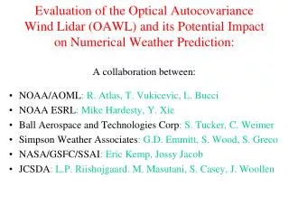
DATA ASSIMILATION FOR HURRICANE PREDICTION Experimental system and results of semi-operational implementation during the 2010 Atlantic Hurricane Season. Tomislava Vukicevic 1 ,

E N D
DATA ASSIMILATION FOR HURRICANE PREDICTIONExperimental system and results of semi-operational implementation during the 2010 Atlantic Hurricane Season Tomislava Vukicevic1 , AltuğAksoy1,2, Kathryn Sellwood1,2 , SimAberson1, Sylvie Lorsolo1,2, XueJin Zhang1,2 and Frank Marks1 1NOAA/AOML Hurricane Research Division 2U. Miami/RSMAS Cooperative Institute for Marine & Atmospheric Studies 3Science Applications International Corporation
Motivation and Objective • There have been few advances in hurricane intensity • prediction in the past 20 years. • NOAA’s Hurricane Forecast Improvement Program (HFIP) goal is to reduce hurricane intensity and track forecasts by 20% by 2016 and 50% by 2021 • High quality in-situ, vortex scale observations are obtained during NOAA, HRD’s annual hurricane field program • Currently no inner-core data is assimilated in operational forecast models • In HRD/AOML research is conducted on assimilation of airborne and other observations into HWRFx model to reduce forecast errors due to poor representation of the initial conditions on vortex scales *Figure from www.nhc.noaa.gov
EnKF Observations Data Assimilation technique Ensemble Kalman Filter (EnKF) • Data assimilation combines model background with observations to obtaina best estimate of atmospheric conditions to initialize a model run • An ensemble of short-range forecasts provides the flow-dependent background covariance information For the assimilation of obs, use covariances sampled from the ensemble of forecasts Subsequent forecast cycle is initialized from the previous analysis ensemble Instead of a single state that represents the initial state of the atmosphere … Analysis uncertainty becomes the initial condition uncertainty for the new forecast cycle … Start with an ensemble of states (ensemble members) that better represent the initial uncertainty about the “mean” state t = t0 t = t0+Δt t = t0+2Δt
Forecast model: • HRD’s Experimental HWRF (HWRF-X) • 2 nested domains (9/3 km horizontal resolution, 42 vert. levels) • Static inner nest to accommodate covariance computations • Inner nest size: ~10x10 degrees • Explicit microphysics on inner nest • Data assimilation: • Square-root ensemble Kalman filter, EnKF (Whitaker and Hamill 2002) with covariance localization (Gaspari and Cohn 1999) • Assimilates inner-core aircraft data on the inner nest • NOAA P-3, NOAA G-IV, USAF, PREDICT G-V • Ensemble system: • Initialized from semi-operational GFS-EnKF (NOAA/ESRL) ensemble • 30 ensemble members HRD’s experimental Hurricane Ensemble Data Assimilation System (HEDAS)
2010 HEDAS Semi-Real-Time Runs for HFIP:DA Cycling Workflow • Only ran when Doppler radar wind data was available from NOAA P-3 flights( 19 cases) • Used 1452 processors on NOAA’s tJet cluster (supported by HFIP) Deterministic HWRF-X Forecast from Ens. Mean Ensemble Spin-up DA Cycling with EnKF T – 6 h T T + 126 h 1-hour Cycles Real-Time Observation Pre-Processing Ensemble Initialization from T-6h GFS-EnKF Mean of Final Analysis Assumed Valid for T
2 NOAA Orion P-3 Dropsonde + Flight level + Tail Doppler Radar 1 NOAA Gulfstream G-IV Dropsonde Observations Observation distribution (9/02/2010 02Z analysis) Data types flight level: wind temperature and humidity + SFMR surface wind GPS dropwindsonde: wind, temperature, humidity and pressure Tail Doppler Radar: radial winds. Approximate vertical location Orion P3: ~ 3 km G-IV : 1300 - 1400 km and U.S. A.F. C-130’s: 10km maximum with a minimum 2000ft. vertical separation from the P3’s U.S.A.F WC-130J Flight level + Dropsonde
2010 HEDAS Semi-Real-Time Runs for HFIP:Summary of Cases • A total of 19 cases were run (when NOAA P-3’s collected Doppler radar data) Number of Observations Assimilated per Cycle Number of Observations Number of Cycles
Storm size and Intensity in HEDAS Analyses Earl Karl Richard Tomas Weak System
EARL KARL RICHARD TOMAS Aug. 31 00Z Sep. 17 00Z Oct. 23 06Z Nov. 7 00Z (11 cases) (4 cases) (1 case) (3 cases) HEDAS Analysis H*Wind Analysis Radar Dropsonde Composite MaxV = 46.7 m/s MaxV = 35.2 m/s MaxV = 16.2 m/s MaxV = 31.2 m/s Max V = 58.1 m/s MaxV = 42.2 m/s MaxV = 19.5 m/s MaxV = 32.9 m/s H*WIND (Powell et al. 1996) is an objective analysis of the wind speed distribution in hurricanes from a variety of observational platforms
Overall Forecast Performance in 2010from HEDAS Analyses Intensity Error(kt) Track Error (km) Number of Cases HEDAS (in blue) performs better in intensity and comparably in track (to HWRF and HWRFx)
Summary of HEDAS Performance during year 1, 2010: • Improved 3D atmospheric mesoscle state analysis, consistent with independent 3D Doppler radar wind and operational hurricane surface wind analyses and the airborne observations of temperature, humidity and wind at vortex scale • Initial conditions from HEDAS mean analysis in average produced better intensity forecasts at lead times longer than 18 hours compared to the operational HWRF forecasts and semi-operational HWRFx forecasts but with the operational initial condition • The analyzed maximum surface wind was underestimated in HEDAS’ analysis during periods with strong and intensifying hurricane (the cases of hurricane Earl while category 3 and 4) • Similar to the results with other regional hurricane forecast systems, the short-term intensity forecast errors were large in average
Challenges to overcome Modeling uncertainties and limitations in observations • Diagnostic analysis of cases with largest intensity errors in the HEDAS analysis indicates that the forecast model deficiencies in PBL parameterization together with insufficient amount of observations in the PBL are likely cause of the errors • Including the model error representation in HEDAS and additional observations are needed to further improve the analysis