Download
1 / 25
260 likes | 276 Views
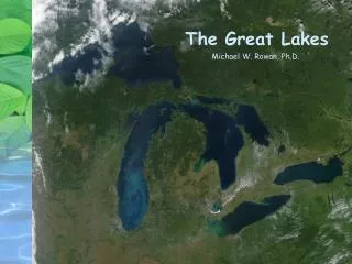
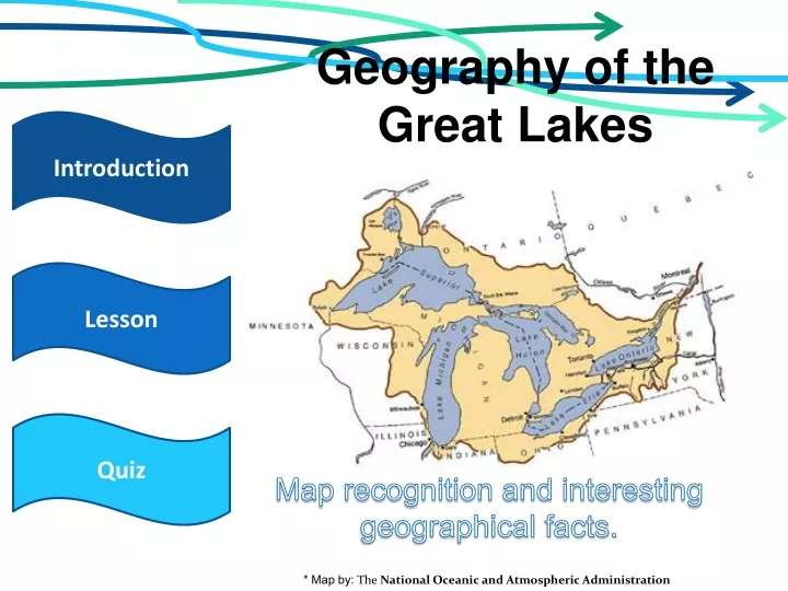
Geography of the Great Lakes. Introduction. Lesson. Quiz. Map recognition and interesting geographical facts. * Map by: The National Oceanic and Atmospheric Administration. Introduction. Level: K 5-7 Subject: Geography

E N D
Geography of the Great Lakes Introduction Lesson Quiz Map recognition and interesting geographical facts. * Map by: The National Oceanic and Atmospheric Administration
Introduction • Level: K 5-7 • Subject: Geography • In this interactive lesson, you will learn to recognize all of the Great Lakes and their geographical locations, as well as some interesting fun facts. • The Great Lakes, in their current state, are actually one of the youngest natural features on the North American continent. • The Great Lakes--Superior, Michigan, Huron, Erie and Ontario--and their connecting channels form the largest fresh surface water system on Earth. If you stood on the moon, you could see the lakes and recognize the familiar wolf head shape of Lake Superior, or the mitten bounded by lakes Michigan, Huron and Erie. Fun Facts:Spread evenly across the contiguous 48 states, the lakes' water would be about 9.5 feet deep. All five of the Great Lakes are among the world's 18 largest lakes by area and volume. The Great Lakes and islands within them have more than 10,000 miles of coastline. Lesson Start Home
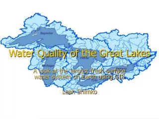
The Great Lakes contain the largest supply of fresh water on earth; 20% of the earth's total fresh water; 9,402 miles of shoreline; and 94,710 total square miles of surface area (about the size of Texas). The Great Lakes basin is a 295,200 square mile area within which all surface area drains into the Great Lakes. It includes parts of Illinois, Indiana, Michigan, Minnesota, New York, Ohio, Pennsylvania, Wisconsin, Ontario and Quebec. To remember the Great Lakes names, remember the word "HOMES." H=HuronO=OntarioM=MichiganE=ErieS=Superior Next Slide
Lake Superior "Uppermost Lake" (French); Kitchi-gummi, a Chippewa Indian translation, signifies "Great Water," or "Great Lake." A Jesuit name, "Lac Tracy," was never officially adopted. Superior is the largest of the Great Lakes by surface area and volume, and rich in natural resources. Surface Area: 22,278 mi2 / 57,750 km2 Volume: 1,180 mi3 / 4,920 km3 Length: 307 mi / 494 km Depth: 279 ft / 85 m average; 925 ft / 282 m maximum Shoreline Length: 1,659 miles / 2,670 km (including islands) Elevation: 581 ft / 177 m Outlet: Straits of Mackinac to Lake Huron Retention/Replacement Time: 99 years Next Slide *Images from: Google Images.
Surface Area: 22,278 mi2 / 57,750 km2 Volume: 1,180 mi3 / 4,920 km3 Length: 307 mi / 494 km Depth: 279 ft / 85 m average; 925 ft / 282 m maximum Shoreline Length: 1,659 miles / 2,670 km (including islands) Elevation: 581 ft / 177 m Outlet: Straits of Mackinac to Lake Huron Retention/Replacement Time: 99 years Lake Michigan Champlain called it the Grand Lac. It was later named "Lake of the Stinking Water" or "Lake of the Puants," after the people of other nations who occupied its shores. In 1679, the lake became known as Lac des Illinois, because it gave access to the country of the Indians of that name. Allouez called it Lac St. Joseph, by which name it was often designated by early writers. Others called it Lac Dauphine. Through the further explorations of Jolliet and Marquette, it received its final name of Michigan, Algonquian for "Great Water." Michigan is the third largest Great Lake (although Lake Huron-Michigan, at 45,300 mi2 / 117,400 km2 is technically the world's largest freshwater lake. Next Slide
Lake Huron Since its French discoverers knew nothing as yet of the other lakes, they called it La Mer Douce, the sweet or fresh-water sea. A Sanson map in 1656 refers to it as Karegnondi. Huron is the second largest Great Lake (although Lake Huron-Michigan, at 45,300 mi2 / 117,400 km2 is technically the world's largest freshwater lake. This is because what have traditionally been called Lake Huron and Lake Michigan are really giant lobes of a single lake connected by the five mile wide Strait of Mackinac.) It has the longest shoreline of the Great Lakes, counting its 30,000 islands Surface Area: 22,973 mi2 / 59,500 km2 Volume: 850 mi3 / 3,540 km3 Length: 206 mi / 331 km Depth: 194 ft / 59 m average; 748 ft / 229 m maximum Shoreline Length: 3,827 miles / 6,157 km (including islands) Elevation: 581 ft / 177 m Outlet: St. Clair River to Lake Erie Retention/Replacement Time: 22 years Next Slide
The greater part of its southern shore was at one time occupied by the Eries, a tribe of Indians from which the lake derived its name. This name is always mentioned by the early French writers as meaning "cat"; Lac du Chat means "Lake of the Cat." Many attribute this reference to the wild cat or panther. Lake Erie is the fourth largest Great Lake and is the shallowest and warmest. Lake Erie Surface Area: 9,906 mi2 / 25,657 km2 Volume: 116 mi3 / 483 km3 Length: 210 mi / 338 km Depth: 62 ft / 19 m average; 210 ft / 64 m maximum Shoreline Length: 871 miles / 1,400 km (including islands) Elevation: 571 ft / 174 m Outlet: Niagara River and Welland Canal Retention/Replacement Time: 2.6 years (shortest of the Great Lakes) Next Slide
Champlain first called it Lake St. Louis in 1632. On a Sanson map in 1656, it remained Lac de St. Louis. In 1660, Creuxius gave it the name Lacus Ontarius. Ontara in Iroquois means "lake," and Ontario, "beautiful lake." Ontario is the smallest in surface area of the Great Lakes. Lake Ontario Surface Area: 7,340 mi2 / 18,960 km2 Volume: 393 mi3 / 1,640 km3 Length: 193 mi / 311 km Depth: 282 ft / 86 m average; 804 ft / 245 m maximum Shoreline Length: 726 miles / 1,168 km (including islands) Elevation: 246 ft / 75 m Outlet: St. Lawrence River to the Atlantic Ocean Retention/Replacement Time: 6 years Next Slide
Do you think you are ready to test your Geographical Knowledge? Not yet… Sure!
Next Question You found Lake Superior!
Next Question You found Lake Huron!
Next Question You found Lake Michigan!
Next Question You found Lake Erie!
Next Slide You found Lake Ontario!
Sorry, try again! Try again Back to the Lesson Hint: The largest of the Great Lakes by surface area and volume.
Sorry, try again! Try again Back to the Lesson Hint: Since its French discoverers knew nothing as yet of the other lakes, they called it La Mer Douce, the sweet or fresh-water sea.
Sorry, try again! Try again Back to the Lesson Hint: Is connected to the Lake Huron by a five mile Strait.
Sorry, try again! Try again Back to the Lesson Hint: is the fourth largest Great Lake and is the shallowest and warmest.
Sorry, try again! Try again Back to the Lesson Hint: Has the smallest surface area of the Great Lakes.
Congratulations! You have now mastered Geography of the Great Lakes. Return to the Home Page. View the Lesson again. *basin map from: Great Lakes Atlas, Environment Canada and U.S. Environmental Protection Agency, 1995