Download
1 / 31
460 likes | 2.12k Views
The Great Lakes. It’s History, It’s Future. Ann Rzepka Natural Resources Specialist Geauga Soil and Water Conservation District. Rachel Webb Low Impact Development Coordinator Chagrin River Watershed Partners, Inc. Chagrin River Watershed Partners.

E N D
The Great Lakes It’s History, It’s Future Ann Rzepka Natural Resources Specialist Geauga Soil and Water Conservation District Rachel Webb Low Impact Development Coordinator Chagrin River Watershed Partners, Inc.
Chagrin River Watershed Partners • Formed in 1996 by watershed communities. Supported by member dues and grants. • Work directly with 36 cities, villages, counties, townships, and park districts to minimize flooding and erosion as communities grow. Save $$. • Majority of members required to comply with Ohio EPA’s storm water management rules. Assist with compliance.
Chagrin River Watershed Chagrin enters Lake Erie in Eastlake. Majority of jurisdictions shown belong to CRWP.
Chagrin River Watershed 265 miles2 drainage 71 miles of State Scenic & Coldwater Unstable hillsides Poorly drained soils Suburbanizing 80% original wetlands filled Impaired waters – water quality problems are due to land use practices
Geauga Soil and Water Conservation District “To conserve, protect, and enhance the soil and water resources of Geauga County by providing leadership, education, and assistance to all” Government nonprofit organization – primarily funded by the Geauga County Commissioners and the Ohio Department of Natural Resources Division of Soil and Water Conservation Board of Supervisors MOU’s and working agreements Services provided to Geauga County Residents
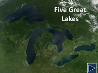
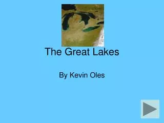
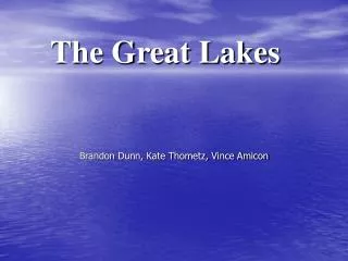
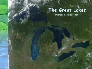
Great Lakes Facts Largest surface freshwater supply in the world ~95,000 Square miles of water 250 Species of fish Drinking Water for 40 Million People $4 Billion Sports Fishery (1/3 of U.S. registered boaters) 56 Billion Gallons per day for Municipal, Agricultural, Industrial 1,000 mile international border 1% annual renewal
Lake Superior Largest of the Great Lakes in surface area and volume. Superior is also the coldest and deepest of the five Great Lakes. Average depths are close to 500 feet; the deepest point in the lake reaches 1,332 feet. Fun Facts Lake Superior's volume is so large that it could contain all the other Great Lakes plus three additional lakes the size of Lake Erie.
Lake Michigan Second largest of the Great Lakes according to volume. The ONLY Great Lake entirely within the United States. Fun Facts The world's largest freshwater sand dunes line the shores of Lake Michigan. Hydrologically speaking, lakes Michigan and Huron are actually "one" Great Lake, separated by the Straits of Mackinaw.
Lake Huron Third largest of the Great Lakes by volume, holding nearly 850 cubic miles of water. Home to many ship wrecks, the lake averages a depth of 195 feet. Fun Facts Lake Huron has the longest shoreline of the Great Lakes, counting the shorelines of its 30,000 islands.
Lake Erie Shallowest of the Great Lakes (averaging only 62 feet) and overall the smallest by volume. Erie is also exposed to the greatest effects from urbanization and agriculture. Fun Facts Lake Erie is the warmest and most biologically productive of the Great Lakes. Built in 1822, Marblehead Lighthouse on Lake Erie is the oldest active light tower on the Great Lakes. The Lake Erie walleye fishery is widely considered the best in the world.
Lake Ontario Similar to Lake Erie in surface area and physical dimensions, Lake Ontario is a much deeper lake, averaging 283 feet. Comparing their volumes, Lake Ontario holds almost four times more water than Lake Erie. Ontario ranks fourth among the Great Lakes in maximum depth, but its average depth is second only to Lake Superior. Fun Facts Lake Ontario lies 325 ft (99 m) below Lake Erie, at the base of Niagara Falls. Niagara Falls were always an obstacle to navigation into the upper lakes until the Trent-Severn Waterway, along with the Welland and Erie canals were built to allow ships to pass around this bottleneck. The oldest lighthouse on the U.S. side of the Great Lakes was set up at Fort Niagara in 1818 to aid navigation.
History of Requests for Diversions of Great Lakes Water The triple whammy that resulted in the Council of Great Lakes Governors
Sporhase Case Water as commerce
Definitions Withdrawal- the taking of water from surface or groundwater, by any means. Withdrawals Resulting in Loss of Water to Great Lakes Basin Diversion- a transfer of water out of the Great Lakes Basin or a transfer of water from the watershed of one Great Lakes to another. Consumptive Loss - water that is lost or not returned to the Great Lakes Basin through processes.
Boundary Waters Treaty 1909 Between US and Canada – designed to resolve border disputes Two large problems with Boundary Waters Treaty Only applied when lake when diversions were large enough to effect lake levels Only applies to boundary water (Lake Michigan is entirely within the US)
Council of Great Lakes Governors January 1982 – Mackinac Island Great Lake Governors and premiers Declared “No Great Lakes Water can be diverted without approval from Great Lakes Governors and premiers and both US and Canadian Federal Governments” 1983 - federal legislation for enforcement failed Problem – no enforcement ability
Great Lakes Charter 1984 - created a task force Declared waters of the great lakes were a precious natural resource “shared and held in trust) Also set diversion and consumptive use thresholds 1985 – Charter signed Three main purposes: To conserve lake levels and flows Provide a cooperative mechanism to manage water resources sustainably To protect the ecosystem Problem – nonbinding agreement ...and Michigan …But it was a good start
Section 1109 WRDA Section 1109(d) of WRDA (42 U.S.C.§1962D-20) - No water shall be diverted or exported from any portion of the Great Lakes within the United States, or from any tributary within the United States of any of the Great Lakes, for use outside the Great Lakes basin unless such diversion is approved by the Governor of each of the Great Lakes States.
The Nova Group and the 2001 Annex PURPOSE In agreeing to this Annex, the Great Lakes Governors and Premiers reaffirm their commitment to the five broad principles set forth in the Great Lakes Charter, and further reaffirm that the provisions of the Charter will continue in full force and effect. The Governors and Premiers commit to further implementing the principles of the Charter by developing an enhanced water management system that is simple, durable, efficient, retains and respects authority within the Basin, and, most importantly, protects, conserves, restores,andimproves the Waters and Water-Dependent Natural Resources of the Great Lakes Basin. State and Provincial authorities should be permanent, enforceable, and consistent with their respective applicable state, provincial, federal, and international laws and treaties.
Some Noteworthy Diversions Chicago Diversion Akron Diversion
Threats to the Great Lakes Commercial and Recreational Fisheries Habitat destruction Beach Contamination Invasive Species Storms, Ice damage, Erosion, High Waves Water level extremes, Climate change Safety of Commercial and Recreational Boating Spills, Contaminated Food or Drinking Water, HAB’s Threats to water quantity and quality
The Great Lakes Compact • 2005 • Governors and premiers signed drafts of the interstate Compact and an international agreement that prohibit most new diversions and exports of water out of the Great Lakes basin. The Compact allows a community that straddles basin • boundaries or lies within a straddling county to request a diversion if: • It has no reasonable water supply alternative, including conservation • Diverted water will be used solely for public supply and returned as treated wastewater to the source watershed (At least 95%) • All Great Lakes governors must approve a diversion to a community in a straddling county. The Compact includes goals for water conservation, sustainable use, and Great Lakes research. • Must be ratified by all the states and provinces to be enacted What it says and where it stands
Thank you! Questions? Rachel Webb Low Impact Development Coordinator Chagrin River Watershed Partner, Inc. 440-975-3870 Annie Rzepka Natural Resources Specialist Geauga Soil and Water Conservation District 440-834-1122 x2