Download
1 / 37
370 likes | 396 Views
Changes to Louisiana’s Coastal Zone Boundary. Presentation Focus. Louisiana Coastal Zone Boundary Changes Why was the coastal zone boundary changed? What does Act 588 require? What are the benefits of those changes? What are the permitting requirements?

E N D
Presentation Focus • Louisiana Coastal Zone Boundary Changes • Why was the coastal zone boundary changed? • What does Act 588 require? • What are the benefits of those changes? • What are the permitting requirements? • What is the DNR Office of Coastal Management (OCM) doing to implement those changes?
History • Louisiana’s initial Coastal Zone Boundary was established in 1978 • Amended in 1979 and 1980 to include additional areas • Senate Concurrent Resolution 60 of the 2009 Legislative Session directed CPRA to perform a science-based evaluation of the Coastal Zone inland boundary • Study was performed by DNR’s Office of Coastal Management from July 2009 through May 2011 with input of numerous stakeholders • Report was presented to CPRA in May 2011 • CPRA passed a resolution in May 2011 accepting the report • Report was provided to Louisiana Legislature June 17, 2011 • CRPA requested Legislature to consider statutory changes for implementation of the report’s recommendations at the earliest possible time • Per Act 956 of 2010 and CPRA May 2011 resolution, a portion of Ascension Parish was included in the La. Coastal Zone
Concerns with Previous Boundary • Coastline had changed significantly since the initial boundary was established • Inconsistent with boundaries of other coastal related programs in Louisiana (CWPPRA, State’s Coastal Master Plan, BTNEP, etc.) • Some coastal wetlands were not included
Science Study Summary • Science-based boundary incorporates environmental changes that have taken place since initial boundary was established in 1978 • The study used information on storm surge, geology, elevation, soil type, vegetation, predicted subsidence/sea level rise, and boundaries of existing coastal programs to identify areas with a high level of coastal influence • New coastal zone boundary incorporates a net increase of 1887 square miles (12.6% increase)
Provisions of Act 588 • Act became effective upon signature of the Governor (June 7, 2012) • Modifies inland boundary of Coastal Zone (12.6% increase in coastal area) • New boundary follows recommendations of the science-based evaluation report accepted by the CPRA and provided to Legislature in 2011
Provisions of Act 588 (cont’d) • Requires an electronic version of new boundary map to be available on the OCM website for viewing/download • Requires DNR Secretary to maintain map(s) depicting areas in coastal zone determined by the Secretary to be a fastland or above the 5-foot contour • Those maps shall be readily accessible to the public for their comparison to proposed project footprints, to help them make their own determination as to whether their activity is exempt (goal is to reduce the number of unnecessary permit applications).
Provisions of Act 588 (cont’d) • Act 588 did not establish or require any new regulations or exemptions. • The same coastal use permit regulations and exemptions that existed prior to Act 588 now apply to those areas that were added to the Louisiana coastal zone by Act 588.
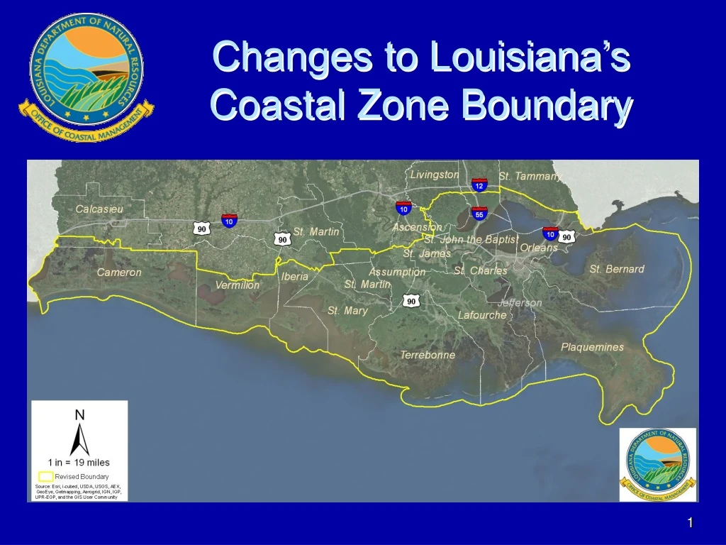
Summary of Boundary Changes • CZ area increased in Cameron, Calcasieu, Iberia, St. Martin, St. Mary, Terrebonne, Lafourche, and Assumptionparishes • CZ area was reduced in Tangipahoa and Livingston parishes • CZ area remains the same in Vermilion, St. John, St. James, St. Charles, Jefferson, Plaquemines, Orleans, St. Bernard, St. Tammany, and Ascensionparishes • No additional parishes incorporated
Five Parishes Were Partially Included Now Entirely Included • Terrebonne • Lafourche • St. Mary • Assumption • Cameron
Three Parishes with Increased Coastal Area – Entire Parish Not Included • Calcasieu • Iberia • St. Martin
Parishes with Decreased Coastal Area • Livingston • Tangipahoa • No longer I-12 • Moves down to Hwy 16, Hwy 42, and Hwy 22
Boundary Change Benefits:Coastal Zone Management • Ensures consistency with the State’s Coastal Master Plan • Provides State management of coastal resources in newly added areas (coastal management is one of cornerstones of State’s coastal protection and restoration efforts) • Reduces wetland impacts and coastal hazards • Requires Federal activities within the newly added areas to obtain a state consistency determination • Reduces processing time for many wetland permits in new CZ areas thru Corps’ use of programmatic general permits • Demonstrates, to the Nation, Louisiana’s strong commitment to coastal sustainability, thereby improving chances for federal funding
Permit Processing PGP vs. Non PGP LDNR-OCM 01/07/2011 AnaY
PGP Benefits • Over 60% of all permits issued by OCM in La. coastal zone are eligible for PGP approval • PGP greatly expedites Corps of Engineers approval for many projects in the La. coastal zone • O&G projects affecting up to 3.5 acres of wetlands are eligible (most O&G permits in CZ boundary are eligible) • PGP eligibility for other projects is up to 3 acres of impacts to non-tidal wetlands and up to 2 acres of impacts to tidal wetlands • OCM does all of the processing and evaluation of the applications • Allows Corps to approve PGP-eligible projects much faster 19
Permitting Requirements in Areas Added to Coastal Zone • Existing coastal use permitting regulations also apply to those areas added to the coastal zone by Act 588, which is became effective June 7, 2012. • Any project in the area added to the coastal zone by Act 588, that had not obtained all necessary state authorizations prior to June 7, 2012, and is not exempt from permitting, will be within the regulatory jurisdiction of OCM and thus require review and permitting by the OCM. • OCM and Local Coastal Program offices are available to assist potential applicants in determining if their proposed project requires a permit, and to assist them with applications when necessary.
OCM’s Regulatory Role • Balance Development and Conservation • Balance Multiple Uses and Limited Coastal Resources 22
Activities Requiring Permits • Oil and Gas Activities – well sites, pipelines, production facilities, gas storage facilities (~60% of all applications) • Commercial Activities – big box stores, boat docks, marinas, subdivisions • Municipal Activities – utilities, roads, drainage, levees • Industrial Activities – refineries, steel mills, coal storage facilities, grain facilities • Other Activities – bulkheads, wharves, boat slips, trenasse clean-out
Exempt Activities • Fastlands (areas completely contained by levees and drained by pump) • Areas above the 5-foot contour • Existing agricultural, forestry and aquaculture activities • Normal maintenance and repair of existing structures • Private camps and residences • Activities which do not have a direct and significant impact on coastal waters
Online Permitting • Allows for online completion, submission and modification of Joint Permit Application • Allows for electronic distribution, online commenting and real-time notification of comments • Allows for online payment of fees • Allows for online tracking of applications with real time status updates 26
OCM Objectives • AVOID • Can adverse impacts to coastal resources be avoided by relocating or redesigning project? • MINIMIZE • Can adverse impacts to coastal resources be minimized by utilizing less damaging construction techniques? 27
Mitigation • Compensatory mitigation is legislatively required replacement, substitution, enhancement or protection of ecological values to offset anticipated losses of ecological values caused by a permitted activity 28
Pre-application Meetings • OCM encourages pre-application meetings to discuss projects early in the planning stages. Agencies can offer input on information requirements and alternatives before the applicant spends potentially large amounts of time and money. • Application processing time can be dramatically reduced by incorporating agency suggestions offered during pre-application meetings. • To schedule a pre-application meeting, please call at 225-342-7591 or send an email to OCMinfo@la.gov 29
Implementing Act 588 • Hosted meetings to inform parish officials and stakeholders on boundary changes and related permitting. Meetings held in Thibodaux, Houma, Patterson and Lake Charles (June & July) • Made OCM permit/mitigation supervisors, senior staff, and field staff available to assist those who may not be familiar with the permitting process • Established a help desk at CPRA’s Thibodaux office to provide assistance to potential applicants in local area • OCM worked with Corps of Engineers to ensure that areas added to the coastal zone are covered by the Programmatic General Permit and joint application process for coastal areas • OCM helped Local Coastal Programs to update their program documents (Lafourche, Terrebonne, Calcasieu, Cameron)
Implementing Act 588 • Maps of new Coastal Zone boundaries are now available on DNR-OCM website for viewing/downloading • Hardcopy maps of new Coastal Zone are projected to be available in a few months
Implementing Act 588 • OCM is providing GIS datasets showing areas currently determined to be fastlands and areas above 5-foot contour, to help the public determine where activities are likely exempt from coastal use permit requirements. • That information is available via DNR’s web site www.SONRIS.com under the GIS link (new). • OCM personnel continue to review GIS datasets and conduct field inspections to determine which areas in coastal zone meet the definition of a fastland. Datasets will be updated as more fastland determinations are made. • To compensate for possible elevation errors, OCM is only depicting those areas shown to be at least above 7 feet, to provide a conservative margin of error.
Web Links • Department of Natural Resources • http://dnr.louisiana.gov/ • Coastal Zone Boundary • http://dnr.louisiana.gov/index.cfm?md=newsroom&tmp=detail&aid=942 • SONRIS • http://sonris.com/ • Office of Coastal Management Coastal Use Permit Search • http://sonris-www.dnr.state.la.us/sonris/cmdPermit.jsp?sid=PROD • Office of Coastal Management Joint Application • http://sonris.com/redirect.asp?linkid=1 • SONRIS Interactive Maps • http://sonris-www.dnr.state.la.us/gis/agsweb/IE/JSViewer/index.html?TemplateID=181
Contact Information • Office of Coastal Management • Hours Monday – Friday 8:00 am-4:30 pm • (800) 267-4019 • (225) 342-7591 • Fax: (225) 342-9439 • Mail Address: P.O. Box 44487, Baton Rouge, La 70804-4487 • Physical Address: 617 North Third St., Baton Rouge, LA 70802 • For Coastal Zone Boundary Questions • CZB@LA.GOV • For Permit and all other Questions • OCMINFO@LA.GOV
THE BIG PICTURE:Long Term Outcome Vision • Sustainable Coastal Communities • Sustainable Commerce and Industry • Sustainable Fisheries Production • Sustainable Coastal Ecology • Sustainable Employment Opportunities • Sustainable Coastal Louisiana Culture