Download
1 / 15
150 likes | 156 Views
This text provides an overview of the aims, outcomes, and action plan of the ICAN-3 Workshop on coastal mapping and informatics. The workshop aimed to strengthen relationships between experts, identify state-of-the-art approaches, establish the International Coastal Atlas Network (ICAN), implement proof-of-concept ontologies and web-based demo prototypes, and more.

E N D
Ned Dwyer Outcomes of ICAN-3 Dawn Wright
Aims of Workshop 1, Cork, 2006 • To create and strengthen relationships between experts in the field in marine and coastal mapping in North America and Europe • To identify state of the art approaches to coastal mapping and informatics
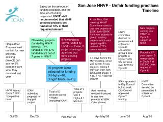
Aims and Outcomes of Workshop 2, Corvallis Aims • Improve searches between atlases • Controlled vocabularies & ontologies • Semantic interoperability • Linkages to use cases, communities Outcomes • Establish International Coastal Atlas Network (ICAN) • Implement proof-of-concept ontologies & web-based demo prototype • Hold further workshops
Activities at Workshop 3, Copenhagen • Reviewed 1st interoperability prototype • Consolidated strategic directions • Proposed a governance structure • Welcomed new members • Linked to relevant European activities • Set out a 2008-09 action plan
Action Plan Themes • Awareness Raising • Outreach and Training • Documentation • Funding • Technical • Governance • Assessment
Awareness Raising • Poster • Brochure
Awareness Raising • Conferences • GIScience 2008 Park City, UT, USA, • JIGOT 2008, Marseilles, France • Coastal geoTools ’09, Myrtle Beach, SC, USA • EU Maritime Days, Rome, Italy • 3rd INSPIRE Conf. /GSDI 11, Rotterdam, Netherlands • CoastalZone’09, Boston, USA • CoastGIS’09, Itajai, Brazil • Free and Open Source Software for Geospatial (FOSS4G), Australia
Outreach and Training Meetings/Workshops • EUCC - The Coastal Union Meeting • OGC Geosemantics Working Group • GEOSS Architecture Implementation Pilot Workshop, Boulder, CO, USA • FGDC Marine and Coastal Spatial Data Subcommittee Meeting • Spatial Ontology Community of Practice (SOCoP) Workshop, McLean, VA • Littoral 2008, Venice, Italy • USGS Coastal and Marine Geology Program teleconference series • West Coast Coastal Atlas Coordination Meeting
Outreach and Training Training • CoastGIS 09, Brazil • GeoNetwork and Mapserver • ODINAFRICA African Marine Atlas Task Team Meeting , Belgium • MIDA, ICAN, Atlas Technologies (visualisation, metadata) • INSPIRE /GSDI Conferences, Netherlands • ICAN workshop
Outreach and Training Outreach Handbook of Research on Coastal Informatics Publication: 2010
Documentation • Resource Section on Website • Handbook
Funding • NSF travel Grants for 2009/2010 • EU Framework 7 • NETMAR (ICAN case study)
Technical • ICAN Portal - www.icoastalatlas.net • ICAN Prototype
Governance • Developed strategic plan • Plan for formal governance • Outline business model
Assessment • CWA Inventory, USA • ICAN CWA inventory • Coastal wiki database • Web-based user survey tool • Developer survey • Benefits of semantic interoperability