Download
1 / 18
190 likes | 197 Views
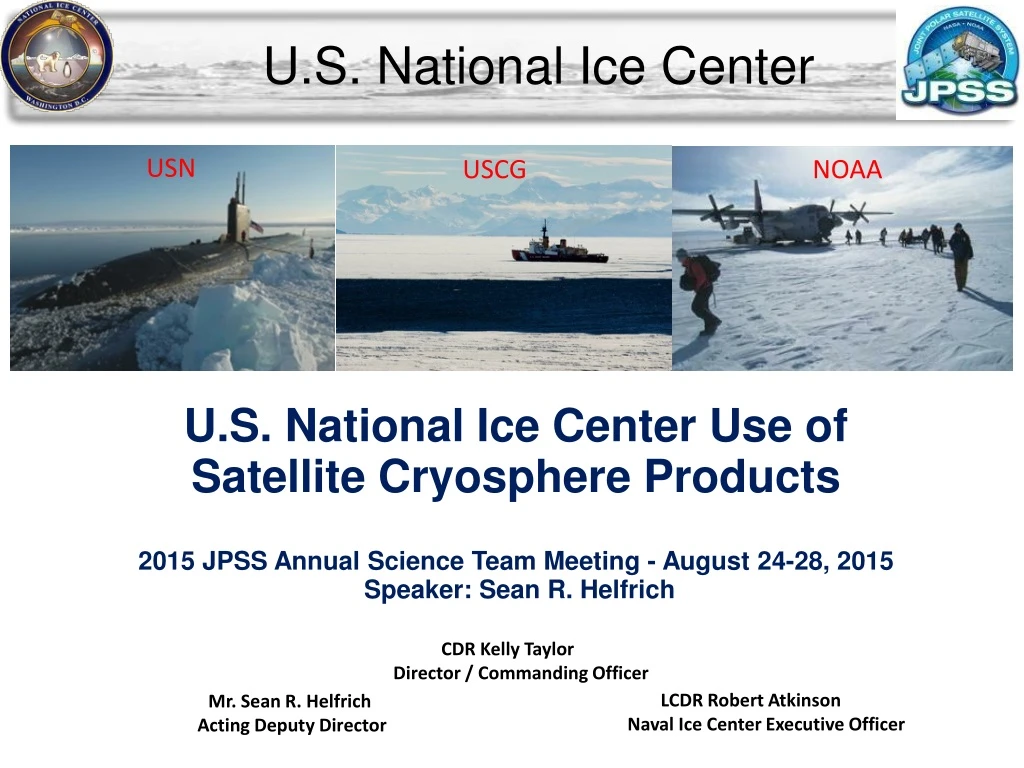
U.S. National Ice Center. USN. USCG. NOAA. U.S. National Ice Center Use of Satellite Cryosphere Products 2015 JPSS Annual Science Team Meeting - August 24-28, 2015 Speaker: Sean R. Helfrich. CDR Kelly Taylor Director / Commanding Officer. LCDR Robert Atkinson

E N D
U.S. National Ice Center USN USCG NOAA U.S. National Ice Center Use of Satellite Cryosphere Products 2015 JPSS Annual Science Team Meeting - August 24-28, 2015 Speaker: Sean R. Helfrich CDR Kelly Taylor Director / Commanding Officer LCDR Robert Atkinson Naval Ice Center Executive Officer Mr. Sean R. Helfrich Acting Deputy Director
USNIC Organization Commander Naval Information Dominance Forces (NAVIDFOR) Asst. Commandant for Prevention Policy (CG-5P) National Environmental Satellite, Data & Information Service (NESDIS) Commander Naval Meteorology & Oceanography Command (CNMOC) Director of Marine Transportation Systems (CG-5PW) Office of Satellite and Product Operations (OSPO)/ Center for Satellite Applications & Research (STAR) Office of Waterways and Ocean Policy (CG-WWM) Naval Oceanographic Office / Fleet Weather Center Norfolk (NAVOCEANO/FWC-N) Mobility and Ice Operations Division (CG-WWM-3) Naval Ice Center (NAVICECEN) US National Ice Center (NIC) Total manpower: 37 personnel; 65% Navy, 33% NOAA, 2% USGC
NOAA Requirements • Great Lakes Ice Monitoring (Dec-May) • Daily Ice Conc/thickness. 5 km res ,GRIB and ASCII • Weekly Ice Thickness & Form • 1-7 day forecast • NAVTEXT message (Dec-Mar) • CONUS Ice Monitoring (Dec-May) • Weekly or bi Weekly - Chesapeake and Delaware Bays • Alaska Ice Monitoring • Twice weekly ice charting • SAR Imagery support for NWS Alaska • Ice edge and GRIB format • Global Snow and Ice Monitoring • 2x Daily Gridded Ice/Snow Extent for North America, 1km • Global Daily Snow Depth, 4km res • Northern Hemisphere Daily Ice Concentration, 4km res • Northern Hemisphere Daily Ice Thickness, 4km res • Days since last observation for Snow and Ice Analysis Data • Special Support of NOAA Vessels
USN Requirements • Submarine Force (SUBFOR) Requirements (USN) • Daily ice edge within 3NM • Daily MIZ within 3NM • 48HR ice edge forecast within 3NM • Sea ice routing/FLAP - as required (up to 2X daily) within 4NM • Estimated ice thickness bi-weekly or as required within 10cm • Iceberg location within 3NM (Arctic/Antarctica) • Climatological outlooks as required • Fleet Weather Center (FWC) Requirements (USN) • Ice edge information (generic), 25 km res, daily. • Ice coverage (analysis and 24 hour forecast) 0.5km res, daily or as required in ports/waterways • Ice thickness information, 0.5 m red, or as required for tactical ops • Route specific at 0.5 km • OTSR ice annotated imagery
USCG Requirements Arctic / Antarctic Daily Sea Ice Edge – Daily during operations, 2x month off season. Arctic – w/i 50m of edge; Antarctic w/i 2nm Daily Sea Ice Concentration – Daily during operations, 2x month off season. Arctic – w/i 50m and 2/10ths coverage FLAP - As requested - daily during operations, 2x month off season. Features >200m in length Daily Estimated Sea Ice Thickness - Daily during operations, 2x month off season Daily Iceberg Location – Daily during operations, 2x month off season. w/i 2 km of actual; Imagery w/I 3 hrs of receipt Daily Imagery Analysis/Forecast – As requested for operations/environmental awareness w/i 100nm radius of vessel Climatological Outlooks - as requested Arctic w/I 25nm; Antarctic w/I 20nm Icebreakers or Aerial Recon Embarked ice analysts or Aerial Recon for real time ice observations and analysis as requested Annotated imagery analysis/forecasts
Arctic Maritime Domain Awareness + Aircraft Webcam Buoys Models Surface Obs Ship Obs International Partners Radar Satellites Product Generation Fractures, Leads and Polynyas (FLAP) Annotated Images Geographic Information System Interpretive Snow and Ice Analysis and Ice Forecasting Meteorology Blended Snow and ice cover Automated Snow and Ice products Antarctic Icebergs Ice Thickness Estimations Semi-automation Hemispheric and Regional Ice Charts Blended Snow Depth Subject Matter Expertise Ice Outlooks
Current SNPP Utility in NIC Products • Imagery (I1, I2, I3, I5, DNB) (All) • VIIRS Sea ice characterization (IMS) Only used for Ice/No Ice (inaccurate ice typing), Cloud Mask issues • VIIRS Sea Ice concentration IP (Working on IMS, Hemi Ice Charts, & MIZ) Data format (HDF5 to Geotiff conversion being built) Will be helpful in IMS Blended Ice Con. • VIIRS Snow cover (IMS) OK, but conservative cloud mask 2014-10-20 22:32 UTC (JD293) Imagery from UAF/GINA
Direct Import of Automated Snow & Ice Cover VIIRS SICoverly IMS With VIIRS I1,I2,I3 overlay • Analysts will be able to selectively import the data from satellite derived products directly into the Blended Analysis • Analysis will have selection box to select snow cover and ice cover from the VIIRS, NOHRSC, and NH AutoSnowIce. • Human data selection to optimize product use based on expert knowledge and imagery interpretation • Combines the speed and reliability of automated products with the QC and flexibility of Human Analysts IMS after SIC Select replacement
Current SNPP Utility in NIC Products 5. AMSR2 Ice Concentration (MIZ, Hemispheric Ice Charts) Applied in IMS Blended Ice Concentration Using ASI (Univ Bremen), last resort data source, 6. ATMS Snow Water Equivalent (IMS) Used to make IMS Snow Depth Release of Version 11.1 – better agreement with AMSR 2 except in boreal forest areas 0 Concentration 100
Oper (v11) Bkg=SWE Climo (v11.1) Snow Water Equiv. (mm) MiRS F18 MiRS F18 JAXA AMSR2 2013-01-30 MiRS N18 GlobSnow MiRS N18 Climo Grassati, ESC 2015
Potential JPSS Utility in NIC Products 7. ATMS Snow Grain Size (IMS) Desired to adjust IMS Snow Depth 8. ATMS First Year Ice Concentration (IMS, Hemispheric Ice Charts) Could be used in IMS Blended Ice Con 9. ATMS Multi-Year Ice Concentration (IMS, Hemi Ice Charts) Will be helpful in IMS Blended Ice Con Metop B AMSU Assending 8/9/14 SNPP ATMS desending 8/9/14
Total Ice MYI MIRS ATMS Sea Ice Total Ice MYI
NIC JPSS Wish list for Future Work • Geotiff formats (All) NIC spends much of its infrastructure, bandwidth and processing on file conversion from HDF formats from VIIRS and MODIS leaving the majority of the content • Include Lake ice in the Ice products (IMS, Great Lakes Analysis) • Product Composites at 1km (IMS, Hemispheric Ice Charts) Difficulty stitching multiple swath and resampling to lower resolution • Ice Edge (Marginal Ice Zone) • Ice Drift (Ice Forecasting, IMS, annotated imagery) • Ice Lead Detection (FLAP, Annotated Imagery) • Snow Fraction (IMS, ASI) • Blended products (All) • Optional Cloud masks (All) CREST experimental Ice Cover 7/31/13
IMS Blended Sea Ice Concentrations BLENDED ICE CONCENTRATIONS: STAR and NIC are developing a Blended Ice Concentration primarily for modeling • Using Optimal Interpolation to blend ice concentrations • New “replacement” using: • SAR • Ice Charts • Other ice/no ice products (CREST, VIIRS RR, GOES R) • Date since last ob and source tracking • Ice Concentrations determined from: • IMS Ice Cover • AMSR 2 • ATMS MIRS • VIIRS Ice Con • Ice Charts (NIC, CIS, DMI, MetNo, NWS Alaska, etc) • Analyst “tie Points” • NWP models • 2016 Release?
NIC & NOAA Arctic Action Plan (2012) Blended IMS Ice Concentrations • Improve ice, weather and water forecasts and warnings • Improve snow depth, snow cover, ice cover, and ice thickness analysis for operational model initialization or assimilation • Integrate new satellite-derived sea ice information into National Ice Center operations, such as ice thickness, ice concentration, and size of leads (fractures) in ice • Advance our sea ice services through the addition of more observational data sets to our analysis and forecasting techniques, evaluations of coupled model output from Environment Canada and the Naval Research Laboratory, and the expansion of product suites with new and more frequent services. • Establish foundational components of a Regional Operations Center and Arctic Test Bed to strengthen NOAA's ability to be responsive to emerging service requirements in the Arctic and leverage new science and technology capabilities. GIOPS CMC Ice Concentrations
NIC & NOAA Arctic Action Plan (2012) • Strengthen foundational science to understand and detect Arctic climate and ecosystem changes • Conduct coordinated calibration and validation of satellite measurements of the cryosphere through in-situ and airborne missions in collaboration with national and international partners • Enhance international and national partnerships • IICWG, NAIS, NASA, U of Washington, IABP, WMO Cryosphere Watch • Coordinating with national and international partners to broaden geographic coverage of Arctic sea ice analysis and forecasting
Integration with Models NIC Analysis CUSTOMERS & PUBLIC Navy and NOAA Models (and others) Models provide forecasts for NIC forecasters which apply NIC analysis data.