Download
1 / 53
530 likes | 533 Views
This article discusses the formation of mountains, including their location, composition, and the geological evidence and theories behind their formation. Topics include geosynclinal theory, continental drift, isostasy, and the accumulation of anomalies.

E N D
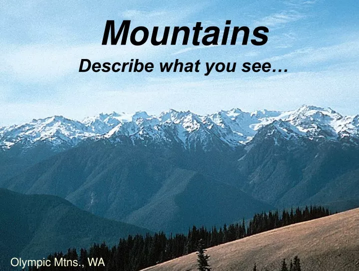
Mountains Describe what you see… Olympic Mtns., WA
Mountains Where are they located? 1 2 6 3 4 5
Mountains What are they made of? Half Dome, Yosemite Valley, CA
Barrovian Facies Series of the SouthernAppalachians The Barrovian Facies Series occurs in the southern Appalachians, extending from Central Virginia to Alabama. Interpretation of the relationship between deformation and metamorphism is complicated by the fact the region has experienced at least three mountain building events, and thrust faults cut the area. http://www.tulane.edu/~sanelson/eens212/regionalmetamorph.htm
(1813-1895) James D. Dana Permanence of oceans Wrote “Geological results of the Earth’s contraction in consequence of cooling” - 1847 Oceans are permanent, continents are stable
(1849-1937) Mountainside fold nappe in Norway Albert Heim Alpine terrain, fold nappes Worked in the Alps, documented mountain-scale folds and large horizontal displacements; constructed terrain models of Swiss alps
Isostasy suggested that mountains formed by vertical movement of the crust However… • What is the heat source for metamorphism or melting? • What produces the petrologic complexity among mountain ranges? • How do we account for kilometers of horizontal displacement in mountain ranges like the alps?
James Hall Geosynclinal theory State Paleontologist of New York; proposed geosynclinal theory in 1857 (1811-1898) • GEOSYNCLINES • • fixed linear troughs at margins of, or within, continents • deep water sediments and volcanic rocks in center, (eugeosyncline: high deformation) • shallow water sedimentary rocks on flanks (miogeosyncline: mild deformation) • • deformation is symmetrical with thrusting away from center • onto adjacent continental platforms to produce orogens
(1904-1974) George Marshall Kay Geosynclinal theory Wrote “North American Geosynclines” - 1951
What part of the southern Appalachians would be the miogeosyncline?
So now we have a mechanism for both horizontal and vertical displacements in mountains But what about fossil correlations between continents? Other geological evidence??
(1831-1914) Eduard Suess Gondwanaland Documented the Glossopteris fern on present-day continents: Glossopteris But isostasy says that land bridges shouldn’t sink ! Gondwanaland connected by ancient land bridges
Antonio Snider-Pellegrini Continental fit and “drift” 1858 - “Creation and its Mysteries Resolved” Noah’s flood caused the continents to break up and drift apart S. America and Africa break up and drift apart
Frank Bursey Taylor Drift of continents toward equator 1910 - “Bearing of the Tertiary mountain belt on the origin of the Earth’s plan” Tidal forces induced movement of continents toward equator
(1880-1930) Alfred Lothar Wegener Paleoclimatic evidence Evidence for Permo-Carboniferous inland glaciation on several present-day continents
(1880-1930) Alfred Lothar Wegener Continental Drift 1915 - “Die Entstehung der Kontinente und Ozeane” 1924 - “The Origin of Continents and Oceans” “Scientists still do not appear to understand sufficiently that all earth sciences must contribute evidence toward unveiling the state of our planet in earlier times, and that the truth of the matter can only be reached by combing all this evidence…It is only by combing the information furnished by all the earth sciences that we can hope to…find the picture that sets out all the known facts in the best arrangement and that therefore has the highest degree of probability. Further, we have to be prepared always for the possibility that each new discovery, no matter what science furnishes it, may modify the conclusions we draw.”
(1879-1940) Emile Argand Gondwanaland reconstruction 1916 - “Sur l'arc des Alpes occidentales” 1922 - “La Tectonique de l'Asia”
Iron/Magnesum-rich rocks Silica/Aluminum-rich rocks
(1878-1948) Alexander Du Toit South America - Africa geologic connections 1927 “A Geological Comparison of South America with South Africa” 1937 “Our Wandering Continents” The same fossils and the same rock units in Africa and South America
Reginald A. Daly Gravity sliding 1926 - “Our Mobile Earth” (1871-1957)
Arthur Holmes Convection in a molten substrate 1945 - “Principles of Physical Geology” (1890-1965)
Complications for Continental Drift • Causal mechanism for drift? • Tidal forces? • Rotation-induced movement towards the equator? • Gravity sliding? • Molten substrate? • And what about isostasy?? • How can more felsic continent crust move through denser, more mafic oceanic crust? • Why isn’t there any evidence for this movement on the ocean floor?
The Submarine Cable Project Samuel Morse invented the telegraph in the 1830’s, but it would only work on land. Messages to/from Europe still required ships, but in 1858, a transoceanic cable was laid But they found that the ocean floor was not as deep as expected in the middle.
The Challenger Expedition of 1872 HMS Challenger was the first dedicated oceanographic expedition Soundings not only determined ocean depth, but returned samples from the ocean floor Depths varied widely, sediments varied, fossils varied, contrary to current thought
So What? • Conventional theory stated that the ocean floor was simply submerged land; • The shallowing in the mid-ocean seemed to support this, but only marine fossils were found in the mid-ocean; • Areas of incredible depth were not accounted for by this theory.
Sonar • During WWI, German U-boats nearly destroyed the British merchant fleet. As a result, the British sought a technological edge, using passive hydrophones to listen for U-boats; • In the 1920’s the British feared a repeat in the future, forming the Anti-Submarine Detection Investigative Committee (ASDIC) to create an active system; • A similar device was invented in the US, called SONAR (Sound Navigation and Ranging); • Sound waves were sent out and timed for the return reflected waves.
Sonar • Harry Hess, naval reserve officer, called up during WWII, used the SONAR on his ship to collect data on shape of the sea floor; • Not only did the depth vary, but so did the thickness of the sediment layers on top of the sea floor
Gravity Surveys • As stated earlier, the force of gravity varied in unexpected ways, being stronger or weaker in ways that could not be accounted for by current theory; • Sensitive torsional balances could detect variations in mass, but were sensitive to vibrations; • Pendulums were less sensitive to vibration, but more sensitivity was needed.
Gravity Surveys • A Dutch scientist, Felix Vening Meinesz developed such a gravitometer, detecting differences in the period of co-planar pendulums; • A difference in T meant a difference in g. • Traveling in the US submarine, S-21, he found variations in gravity to be unexpected - less in areas of sedimentation and more in deep ocean basins.
Gravity Surveys • A later cruise in the S-48 included a young geologist and naval reserve officer, Harry Hess; • A Caribbean cruise found very strong negative anomalies in the deep ocean trenches.
mEm2 mEm2 Fg= G Fg= G d2 d2 m1m2 Fg= G d2 George Airy, revisited If Fg> Fg , then the difference is a positive anomaly If Fg< Fg ,then the difference is a negative anomaly An anomaly is the difference between the predicted and the observed measurement.
Difference between predicted and observed measurements come from: • Higher or lower density rocks, i.e. basalts & gabbros vs. sediments and granites; • Displacement of higher density material by lower density material, i.e. roots of mountains displacing mantle material, subduction zones; • Large masses of rock, such as mountains or ultramafic concentrations.
http://www.csr.utexas.edu/grace/gravity/gravity_definition.htmlhttp://www.csr.utexas.edu/grace/gravity/gravity_definition.html
Magnetic Variations • During WWII, the renewed U-boat threat lead to improvements in SONAR, but also other detection methods; • RADAR could detect surfaced subs, but deep-diving subs could escape even SONAR; • The disruption of the local magnetic field was sought as a way of detecting submerged U-boats.
Local field Disrupted field lines Magnetic Variations
Magnetic Variations • The first such detectors were towed behind a ship, but later were made more compact to fit in aircraft; • More sensitive magnetometers began to detect reversals in the local magnetic field preserved in the sea floor rocks. Magnetometer boom
Magnetic Variations • Vine and Matthews found linear patterns of these variations, with mirror images of the patterns on opposite sides of ocean ridges; • These same rocks were of similar age on opposite sides of the ridge; • Patterns were also offset by apparent faults.
Magnetic Poles • Sensitive magnetometers on land were also used to detect the position of the magnetic poles over time, looking for past shifts of the pole; • But different continents had apparently different pole positions for the same point in geologic time;
So What? • Ocean floor topography more highly variable than expected; • No submerged land bridges found; • Sediment thickness and type more variable than expected; • Variations in gravity not accounted for by vertical movement alone; • Crust was likely more rigid than previously throught; • Magnetic field signature in rocks varied in consistent pattern; • Paleomagnetic poles did not line up for static continents; • Vertical movement could not account for such variations alone.